
Regional Sustainability ›› 2026, Vol. 7 ›› Issue (5): 100390.doi: 10.1016/j.regsus.2026.100390
• Research article • Previous Articles Next Articles
LI Mana,b, ZHAO Lina, HE Haoa, YU Huijiea, DAI Siyuana, Rathnayaka Mudiyanselage Dinesh Madhushanka KARUNARATNAAa, Abu Reza Muhammad Towfiqul ISLAMc,d, WU Donglie, LI Qia, HU Zhenghuaa,*( )
)
Received:2025-08-16
Revised:2026-07-18
Accepted:2026-09-20
Published:2026-09-30
Online:2026-10-12
Contact:
HU Zhenghua
E-mail:zhhu@nuist.edu.cn
LI Man, ZHAO Lin, HE Hao, YU Huijie, DAI Siyuan, Rathnayaka Mudiyanselage Dinesh Madhushanka KARUNARATNAA, Abu Reza Muhammad Towfiqul ISLAM, WU Dongli, LI Qi, HU Zhenghua. Linking land use and cover change to Sustainable Development Goals and carbon storage: A case study in the Yellow River Basin, China[J]. Regional Sustainability, 2026, 7(5): 100390.
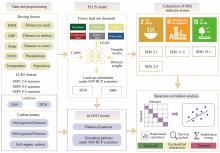
Fig. 1.
Flowchart of the study process. DEM, digital elevation model; GRP, gross regional product; NDVI, normalized difference vegetation index; LUH2, Land-Use Harmonization 2; SSP, Shared Socioeconomic Pathway; PLUS, patch-generating land use simulation; CARS, a cellular automata based on multi-type random patch seeds; LEAS, land expansion analysis strategy; RCP, Representative Concentration Pathway; SDG, Sustainable Development Goal; InVEST, integrated valuation of ecosystem services and trade-offs."
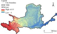
Fig. 2.
Overview of the Yellow River Basin (YRB). Note that the figure is based on the standard map (GS(2024)0650) from the National Platform for Common Geospatial Information Services (https://cloudcenter.tianditu.gov.cn/) issued by the Ministry of Natural Resources of the People’s Republic of China, and the boundary of the standard map has not been modified."
Fig. 3.
Spatial patterns and area proportions of land use types in the YRB in the historical period and in the future under different scenarios. (a), 2010; (b), 2020; (c), under SSP1-2.6 scenario for 2030 (2030 SSP126); (d), under SSP2-4.5 scenario for 2030 (2030 SSP245); (e), under SSP5-8.5 scenario for 2030 (2030 SSP585); (f), under SSP1-2.6 scenario for 2060 (2060 SSP126); (g), under SSP2-4.5 scenario for 2060 (2060 SSP245); (h), under SSP5-8.5 scenario for 2060 (2060 SSP585). The pie charts illustrate the area proportion of each land use type within the YRB."
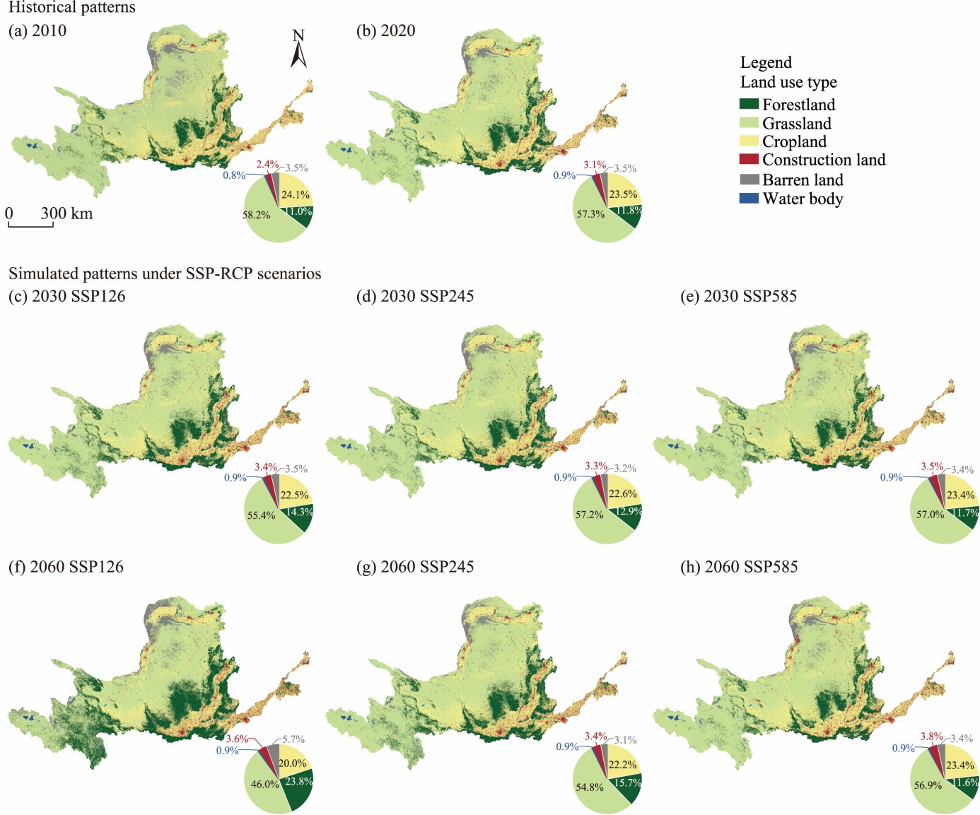
Fig. 4.
Spatial distribution of historical patterns and simulated patterns of SDG 2.1 (a1-a8), SDG 2.4 (b1-b8), SDG 11.2 (c1-c8), SDG 15.1F (d1-d8), and SDG 15.1G (e1-e8) under SSP-RCP scenarios at the city level in the YRB. For each SDG, panels 1-8 correspond to 2010, 2020, 2030 SSP126, 2030 SSP245, 2030 SSP585, 2060 SSP126, 2060 SSP245, and 2060 SSP585, respectively."
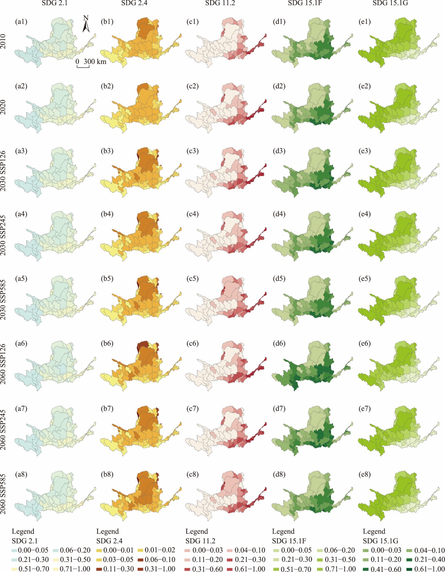
Fig. 5.
Temporal distribution of historical patterns and simulated patterns of SDG indicators under SSP-RCP scenarios at the city level. (a), SDG 2.1; (b), SDG 2.4; (c), SDG 11.2; (d), SDG 15.1F; (e), SDG 15.1G. The coloured circles represent the city-level SDG indicator scores."
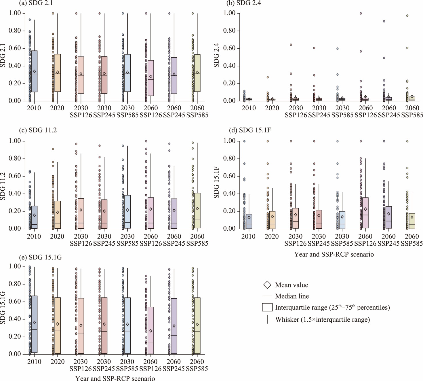
Fig. 6.
Spatial and temporal distributions of normalized carbon storage (CS) in historical patterns (2010 and 2020) and simulated patterns under SSP-RCP scenarios (2030 and 2060) at the city level in the YRB. (a), 2010; (b), 2020; (c), 2030 SSP126; (d), 2030 SSP245; (e), 2030 SSP585; (f), 2060 SSP126; (g), 2060 SSP245; (h), 2060 SSP585. All CS values were normalized between 0.00 and 1.00 to facilitate comparative analysis and consistent visualization."
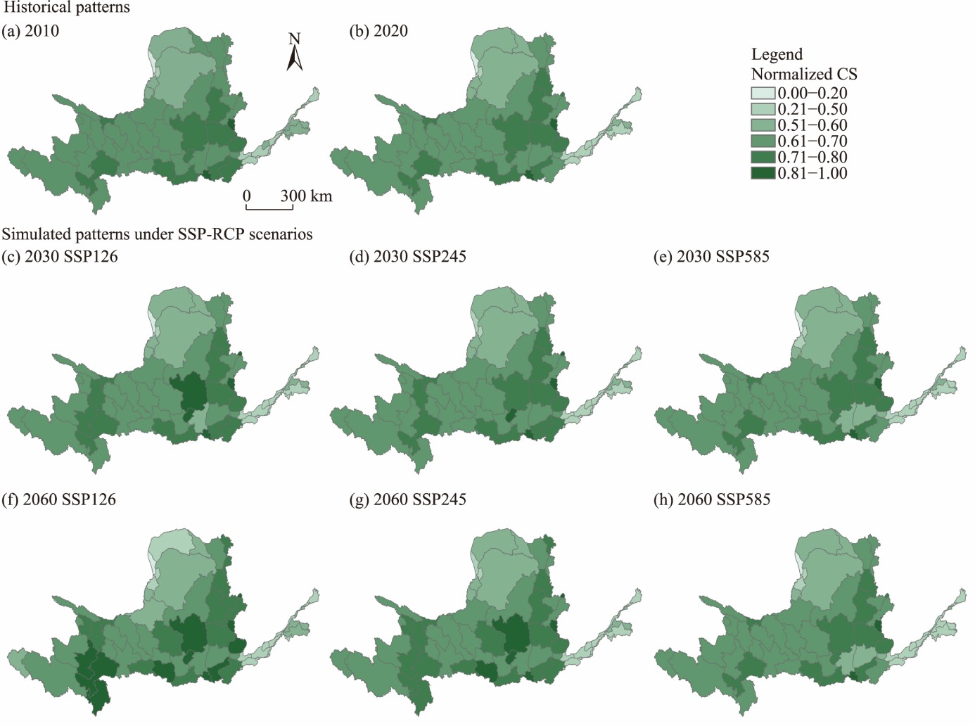
Fig. 7.
Temporal distribution of historical patterns and simulated patterns of normalized CS under different SSP-RCP scenarios at the city level. The coloured circles represent city-level CS values. All CS values were normalized between 0.00 and 1.00 to facilitate comparative analysis and consistent visualization."
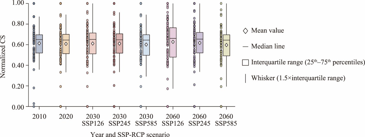
Fig. 8.
Interactions among SDGs and their relationships with CS. (a), interactions among SDGs and between SDGs and CS; (b), synergistic and trade-off relationships among SDGs and between SDGs and CS. For Figure 8a, scatter plots in the lower triangular panels illustrate the relationships between each pair of variables, with the blue solid line indicating the linear regression fit. The diagonal panels display histograms with overlaid kernel density curves, representing the distribution of each variable. In the upper triangular panels, the *, **, and *** symbols represent significant correlations at the 0.050, 0.010, and 0.001 significance levels, respectively."
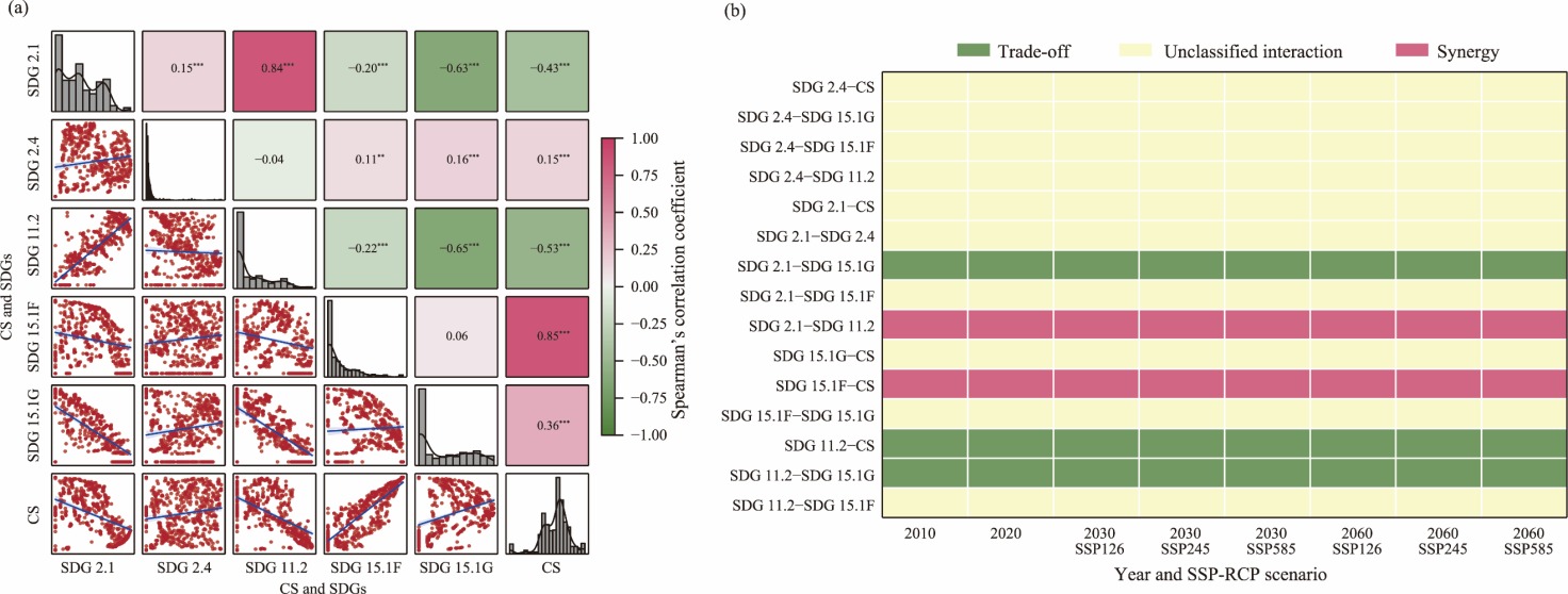
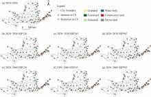
Fig. 9.
Changes in CS driven by the dominant land use and cover change (LUCC) types during distinct periods at the city level in the YRB. (a), 2010-2020; (b), under SSP1-2.6 scenario for 2020-2030 (2020-2030 SSP126); (c), under SSP2-4.5 scenario for 2020-2030 (2020-2030 SSP245); (d), under SSP5-8.5 scenario for 2020-2030 (2020-2030 SSP585); (e), under SSP1-2.6 scenario for 2030-2060 (2030-2060 SSP126); (f), under SSP2-4.5 scenario for 2030-2060 (2030-2060 SSP245); (g), under SSP5-8.5 scenario for 2030-2060 (2030-2060 SSP585). The land use types on the left side of the triangle represent outflow, whereas those on the right side indicate inflows. Note that these figures are based on the standard map (GS(2024)0650) from the National Platform for Common Geospatial Information Services (https://cloudcenter.tianditu.gov.cn/) issued by the Ministry of Natural Resources of the People’s Republic of China, and the boundary of the standard map has not been modified."
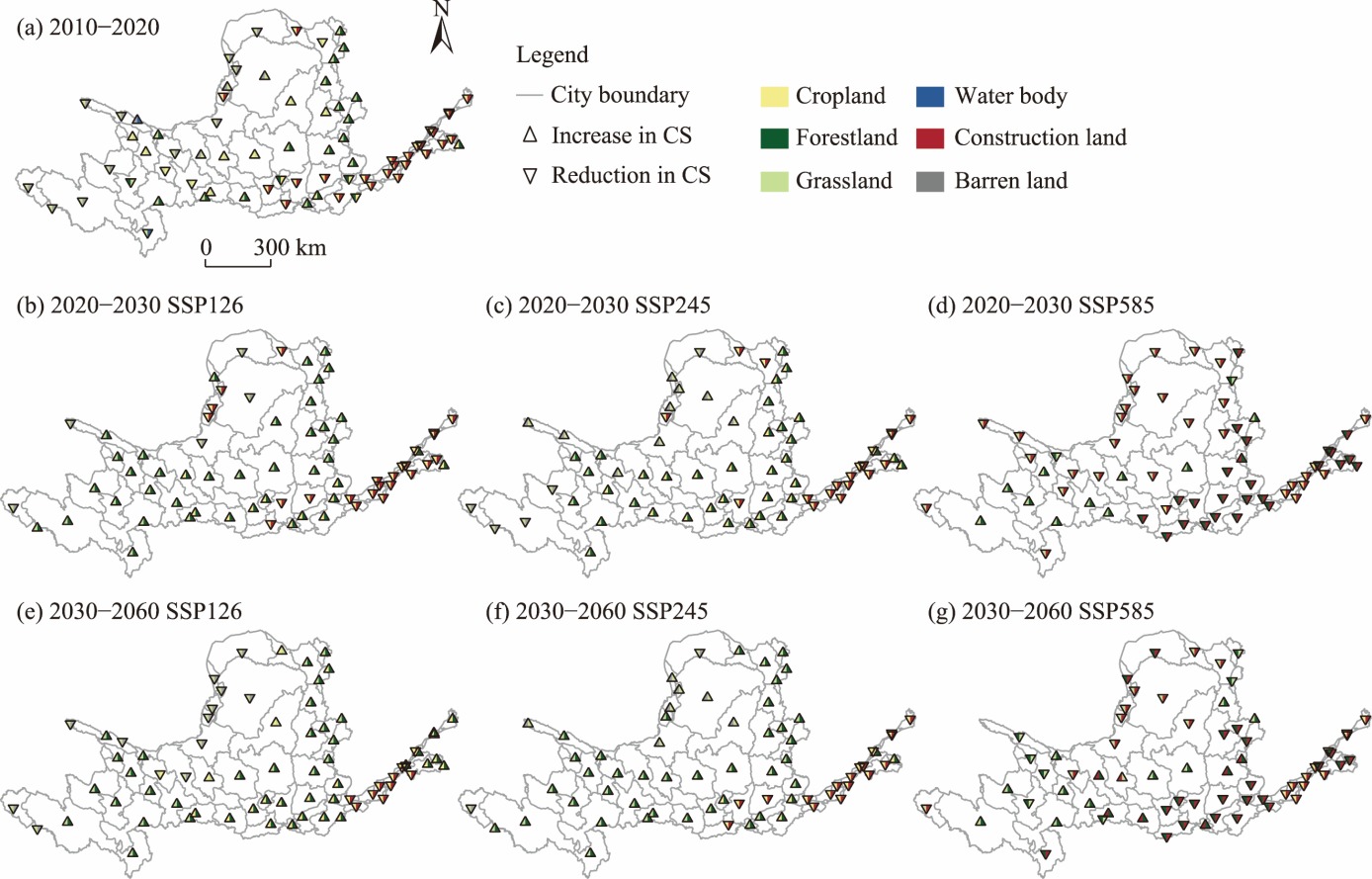
Table S1
Data sources used for this research."
| Category | Data | Source |
|---|---|---|
| Land use | China Land Cover Dataset (CLCD) | Wuhan University CLCD-Land use and cover change (LUCC) Product ( |
| Land-use harmonization 2 (LUH2) data | Land Use Harmonization 2 project ( | |
| Carbon density | Carbon density data | Ecosystem Research Network Data Center ( |
| Socioeconomic factor | Gross regional product (GRP) | Resource and Environment Science and Data Center ( |
| Population data | Liu et al. ( | |
| Natural factor | Temperature | National Earth System Science Data Center ( |
| Precipitation | National Earth System Science Data Center ( | |
| Digital elevation model (DEM) | Resource and Environment Science and Data Center ( | |
| Slope | Resource and Environment Science and Data Center ( | |
| Normalized difference vegetation index (NDVI) | Resource and Environment Science and Data Center ( | |
| Accessibility data | Distance to road, railway, and water | National Catalogue Service for Geographic Information ( |
| Accuracy validation data | Global live vegetation biomass carbon dataset | https://doi.org/10.5281/zenodo.4161694 (Xu et al., |
Table S2
Reclassification of land use types in the LUH2, CLCD, and patch-generating land use simulation (PLUS) model."
| Land use type in the LUH2 | Land use type in the CLCD | Land use type in the PLUS model |
|---|---|---|
| Forested primary land | Forest | Forestland |
| Potentially forested secondary land | Shrub | Forestland |
| Rangeland | Grassland | Grassland |
| Managed pasture | Grassland | Grassland |
| C3 annual crops | Cropland | Cropland |
| C3 perennial crops | Cropland | Cropland |
| C4 annual crops | Cropland | Cropland |
| C4 perennial crops | Cropland | Cropland |
| C3 nitrogen-fixing crops | Cropland | Cropland |
| Urban land | Urban | Construction land |
| Non-forested primary land | Barren | Barren land |
| Potentially non-forested secondary land | Barren | Barren land |
| None | Water body | Water body |
| None | Snow/Ice | Water body |
| None | Wetland | Water body |
Table S3
Carbon density across different land use types in the Yellow River Basin (YRB)."
| Land use type | Cabove (t/hm2) | Cbelow (t/hm2) | Csoil (t/hm2) |
|---|---|---|---|
| Forestland | 31.47 | 8.20 | 75.76 |
| Grassland | 0.75 | 4.70 | 72.10 |
| Cropland | 1.97 | 0.30 | 65.28 |
| Construction land | 0.73 | 7.99 | 0.00 |
| Barren land | 0.38 | 0.00 | 6.28 |
| Water body | 0.09 | 0.00 | 0.00 |
Table S4
Sustainable Development Goal (SDG) indicators used in this study."
| Characterization index | Quantification method | Unit | Attribute | Source | SDG |
|---|---|---|---|---|---|
| Land reclamation rate | Cropland area/total land area | % | + | Qiao et al. (2023) | SDG 2.1 |
| Per capita cropland | Cropland area/total population | km2/capita | + | Jia et al. ( | SDG 2.4 |
| Urbanization rate | Construction land area/total land area | % | + | Yin et al. ( | SDG 11.2 |
| Forestland coverage | Forestland area/total land area | % | + | Xu et al. (2020) | SDG 15.1F |
| Grassland coverage | Grassland area/total land area | % | + | Zuo et al. (2025) | SDG 15.1G |
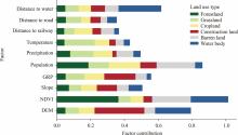
Fig. S1.
Relative contributions of driving factors to the expansion of the six land use types estimated using the random forest algorithm in the patch-generating land use simulation (PLUS) model within the Yellow River Basin (YRB). GRP, gross regional product; NDVI, normalized difference vegetation index; DEM, digital elevation model."
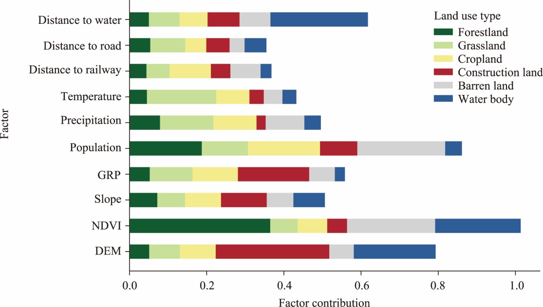
Fig. S2.
Comparison of land use derived from China Land Cover Dataset (CLCD) data (a, a1, a2, and a3) and that simulated by the PLUS model in 2020 (b, b1, b2, and b3) within the YRB."
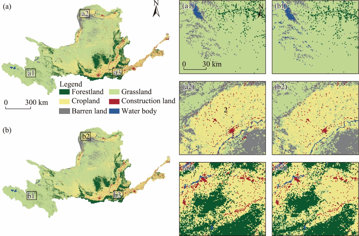
Fig. S3.
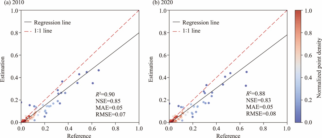
Fitting results between the normalized carbon storage (CS) simulated by the integrated valuation of ecosystem services and tradeoffs (InVEST) model for 2010 (a) and 2020 (b) and the CS of live vegetation biomass developed by Xu et al. (2021) at the city level. The 2019 reference dataset was used to validate the estimated CS in 2020. CS validation was conducted by comparing the 2020 estimates against the 2019 reference values. R2, determination of coefficient; NSE, Nash-Sutcliffe Efficiency; MAE, mean absolute error; RMSE, root mean square error."
| [1] |
Allen C., Nejdawi R., El-Baba J., et al., 2017. Indicator-based assessments of progress towards the sustainable development goals (SDGs): A case study from the Arab region. Sustainability Science. 12(6), 975-989.
doi: 10.1007/s11625-017-0437-1 |
| [2] | Bacani V.M., Machado da Silva B.H., Ayumi de Souza Amede Sato A., et al. 2024. Carbon storage and sequestration in a eucalyptus productive zone in the Brazilian Cerrado, using the Ca-Markov/Random Forest and InVEST models. Journal of Cleaner Production. 444, 141291, doi: 10.1016/j.jclepro.2024.141291. |
| [3] |
Cao M., Tian Y., Wu K., et al., 2023. Future land-use change and its impact on terrestrial ecosystem carbon pool evolution along the Silk Road under SDG scenarios. Science Bulletin. 68(7), 740-749.
doi: 10.1016/j.scib.2023.03.012 pmid: 36934012 |
| [4] |
Cao S.X., Liu Z.X., Li W.M., et al., 2021. Balancing ecological conservation with socioeconomic development. Ambio. 50(5), 1117-1122.
doi: 10.1007/s13280-020-01448-z |
| [5] | Chen L., Yao Y., Xiang K.M., et al., 2024. Spatial-temporal pattern of ecosystem services and sustainable development in representative mountainous cities: A case study of Chengdu-Chongqing Urban Agglomeration. Journal of Environmental Management. 368, 122261, doi: 10.1016/j.jenvman.2024.122261. |
| [6] | Cheng Y.L., Chen Y.B., 2024. Spatial and temporal characteristics of land use changes in the Yellow River Basin from 1990 to 2021 and future predictions. Land. 13(9), 1510, doi: 10.3390/land13091510. |
| [7] | Chu X., Zhan J.Y., Li Z.H., et al., 2019. Assessment on forest carbon sequestration in the Three-North Shelterbelt Program region, China. Journal of Cleaner Production. 215, 382-389. |
| [8] | Colglazier W., 2015. Sustainable Development Agenda: 2030. Science. 349(6252), 1048-1050. |
| [9] | Ding Y.H., Wu P., Liu Y.J., 2022. Modulation of sea surface temperature in three oceans on precipitation increase over Northwest China during the past 60 years: A review. Frontiers in Climate. 4, 1015225, doi: 10.3389/fclim.2022.1015225. |
| [10] | Doelman J.C., Stehfest E., Tabeau A., et al., 2018. Exploring SSP land-use dynamics using the IMAGE model: Regional and gridded scenarios of land-use change and land-based climate change mitigation. Global Environmental Change. 48, 119-135. |
| [11] | Fan L.Y., Cai T.Y., Wen Q., et al., 2023. Scenario simulation of land use change and carbon storage response in Henan Province, China: 1990-2050. Ecological Indicators. 154, 110660, doi: 10.1016/j.ecolind.2023.110660. |
| [12] |
Fuso Nerini F., Sovacool B., Hughes N., et al., 2019. Connecting climate action with other Sustainable Development Goals. Nature Sustainability. 2(8), 674-680.
doi: 10.1038/s41893-019-0334-y |
| [13] | Gao L., Tao F., Liu R.R., et al., 2022. Multi-scenario simulation and ecological risk analysis of land use based on the PLUS model: A case study of Nanjing. Sustainable Cities and Society. 85, 104055, doi: 10.1016/j.scs.2022.104055. |
| [14] | Gao M.N., Xu R.H., Huang J.L., et al., 2023. Increase of carbon storage in the Qinghai-Tibet Plateau: Perspective from land-use change under global warming. Journal of Cleaner Production. 414, 137540, doi: 10.1016/j.jclepro.2023.137540. |
| [15] | Getzner M., Bröthaler J., Neuhuber T., et al., 2025. Socio-economic, political and fiscal drivers of unsustainable local land use decisions. Land Use Policy. 153, 107537, doi: 10.1016/j.landusepol.2025.107537. |
| [16] | González-García A., Arias M., García-Tiscar S., et al., 2022. National blue carbon assessment in Spain using InVEST: Current state and future perspectives. Ecosystem Services. 53, 101397, doi: 10.1016/j.ecoser.2021.101397. |
| [17] |
Guo H.D., Huang L., Luo L., et al., 2023. Progress on achieving environmental SDGs assessed from Big Earth Data in China. Science Bulletin. 68(24), 3129-3132.
doi: 10.1016/j.scib.2023.09.017 pmid: 37739841 |
| [18] | Han L.J., Zhang L.M., Zhou W.Q., et al., 2022. China’s urban-rural expansion and natural habitat loss since the 1980s: Retrospective analysis and future suggestions. Frontiers in Environmental Science. 10, 65174, doi: 10.3389/fenvs.2022.1065174. |
| [19] | He Y.T., Liang Y.J., Liu L.J., et al., 2023. Loss of green landscapes due to urban expansion in China. Resources, Conservation and Recycling. 199, 107228, doi: 10.1016/j.resconrec.2023.107228. |
| [20] | Huang M.L., Mamitimin Y., Abulizi A., et al., 2024. Integrated assessment of land use and carbon storage changes in the Tulufan-Hami Basin under the background of urbanization and climate change. International Journal of Applied Earth Observation and Geoinformation. 135, 104261, doi: 10.1016/j.jag.2024.104261. |
| [21] |
Hurtt G.C., Chini L., Sahajpal R., et al., 2020. Harmonization of global land use change and management for the period 850-2100 (LUH2) for CMIP6. Geoscientific Model Development. 13(11), 5425-5464.
doi: 10.5194/gmd-13-5425-2020 |
| [22] | IPCC (Intergovernmental Panel on Climate Change), 2021. Climate Change 2021: The Physical Science Basis: Working Group I Contribution to the Sixth Assessment Report of the Intergovernmental Panel on Climate Change. Cambridge: Cambridge University Press. |
| [23] | Jia K., Sheng Q.Y., Liu Y.H., et al., 2024. A framework for achieving urban Sustainable Development Goals (SDGs): Evaluation and interaction. Sustainable Cities and Society. 114, 105780, doi: 10.1016/j.scs.2024.105780. |
| [24] | Kong W.L., Shen W.C., Yu C.Y., et al., 2025. The neglected cost: Ecosystem services loss due to urban expansion in China from a triple-coupling perspective. Environmental Impact Assessment Review. 112, 107827, doi: 10.1016/j.eiar.2025.107827. |
| [25] | Li C.X., Lei L.T., Jia X., et al., 2025a. Accuracy and applicability assessment of vegetation types of the land cover products produced in China. Ecological Indicators. 174, 113506, doi: 10.1016/j.ecolind.2025.113506. |
| [26] | Li H.J., Zhang K., Liu Y.Q., et al., 2025b. Spatiotemporal evolution of land use and carbon storage in China: Multi-Scenario simulation and driving factor analysis based on the PLUS-InVEST model and SHAP. Environmental Research. 279, 121860, doi: 10.1016/j.envres.2025.121860. |
| [27] | Liang X., Guan Q., Clarke K.C., et al., 2021. Understanding the drivers of sustainable land expansion using a patch-generating land use simulation (PLUS) model: A case study in Wuhan, China. Computers, Environment and Urban Systems. 85, 101569, doi: 10.1016/j.compenvurbsys.2020.101569. |
| [28] |
Liao W.L., Liu X.P., Xu X.Y., et al., 2020. Projections of land use changes under the plant functional type classification in different SSP-RCP scenarios in China. Science Bulletin. 65(22), 1935-1947.
doi: 10.1016/j.scib.2020.07.014 pmid: 36738059 |
| [29] | Lin X., Jiao X., Tian Z., et al., 2023. Projecting diversity conflicts of future land system pathways in China under anthropogenic and climate forcing. Earth’s Future. 11(10), e2022EF003406, doi: 10.1029/2022EF003406. |
| [30] | Liu Q., Qiao J.J., Li M.J., et al., 2024. Spatiotemporal heterogeneity of ecosystem service interactions and their drivers at different spatial scales in the Yellow River Basin. Science of The Total Environment. 908, 168486, doi: 10.1016/j.scitotenv.2023.168486. |
| [31] | Liu X.P., Liang X., Li X., et al., 2017. A future land use simulation model (FLUS) for simulating multiple land use scenarios by coupling human and natural effects. Landscape and Urban Planning. 168, 94-116. |
| [32] |
Liu X.P., Wang S.J., Wu P.J., et al., 2019. Impacts of urban expansion on terrestrial carbon storage in China. Environmental Science & Technology. 53(12), 6834-6844.
doi: 10.1021/acs.est.9b00103 |
| [33] | Liu Y., Huang B., Guo H.D., et al., 2023. A big data approach to assess progress towards Sustainable Development Goals for cities of varying sizes. Communications Earth & Environment. 4(1), 66, doi: 10.1038/s43247-023-00730-8. |
| [34] | Liu Y.X., Zhao M.Y., 2024. Coupling coordination between carbon storage protection in alpine wetlands and SDGs: A case study of the Qinghai-Tibet Plateau, China. Journal of Cleaner Production. 483, 144260, doi: 10.1016/j.jclepro.2024.144260. |
| [35] | Liu Z.H., Zhou M., Li D.Y., et al., 2025. Co-benefit of forestation on ozone air quality and carbon storage in South China. Nature Communications. 16(1), 2429, doi: 10.1038/s41467-025-57548-5. |
| [36] | Lu Y.W., Chen S.L., 2024. Exploring the realization pathway of carbon peak and carbon neutrality in the provinces around the Yangtze River of China. Journal of Cleaner Production. 466, 142904, doi: 10.1016/j.jclepro.2024.142904. |
| [37] | Luo L., Wang Y.N., Liu Y.C., et al., 2022. Where is the pathway to sustainable urban development? Coupling coordination evaluation and configuration analysis between low-carbon development and eco-environment: A case study of the Yellow River Basin, China. Ecological Indicators. 144, 109473, doi: 10.1016/j.ecolind.2022.109473. |
| [38] | Ma S.L., Huang J.L., Wang X.X., et al., 2025. Multi-scenario simulation of low-carbon land use based on the SD-FLUS model in Changsha, China. Land Use Policy. 148, 107418, doi: 10.1016/j.landusepol.2024.107418. |
| [39] | Mikunda T., Brunner L., Skylogianni E., et al., 2021. Carbon capture and storage and the sustainable development goals. International Journal of Greenhouse Gas Control. 108, 103318, doi: 10.1016/j.ijggc.2021.103318. |
| [40] | National Bureau of Statistics of China, 2022. China Statistical Yearbook 2021. Beijing: China Statistics Press (in Chinese). |
| [41] |
Næss J.S., Cavalett O., Cherubini F., 2021. The land-energy-water nexus of global bioenergy potentials from abandoned cropland. Nature Sustainability. 4(6), 525-536.
doi: 10.1038/s41893-020-00680-5 |
| [42] | O’Neill B.C., Kriegler E., Ebi K.L., et al., 2017. The roads ahead: Narratives for shared socioeconomic pathways describing world futures in the 21st century. Global Environmental Change. 42, 169-180. |
| [43] | Peng K.F., Jiang W.G., Ling Z.Y., et al., 2021. Evaluating the potential impacts of land use changes on ecosystem service value under multiple scenarios in support of SDG reporting: A case study of the Wuhan urban agglomeration. Journal of Cleaner Production. 307, 127321, doi: 10.1016/j.jclepro.2021.127321. |
| [44] | Popp A., Calvin K., Fujimori S., et al., 2017. Land-use futures in the shared socio-economic pathways. Global Environmental Change. 42, 331-345. |
| [45] |
Pradhan P., Costa L., Rybski D., et al., 2017. A systematic study of Sustainable Development Goal (SDG) interactions. Earth’s Future. 5(11), 1169-1179.
doi: 10.1002/eft2.2017.5.issue-11 |
| [46] | Qiao W.Y., Huang X.J., 2022. The impact of land urbanization on ecosystem health in the Yangtze River Delta urban agglomerations, China. Cities. 130, 103981, doi: 10.1016/j.cities.2022.103981. |
| [47] | Qiao X., Liu H.G., Hao Z.X., et al., 2025. Simulating land use change for sustainability: A case study of the northern slope of Tianshan Mountains. International Journal of Digital Earth. 18(1), 2524055, doi: 10.1080/17538947.2025.2524055. |
| [48] |
Runting R.K., Bryan B.A., Dee L.E., et al., 2017. Incorporating climate change into ecosystem service assessments and decisions: A review. Global Change Biology. 23(1), 28-41.
doi: 10.1111/gcb.13457 pmid: 27507077 |
| [49] | Sachs J., Kroll C., Lafortune G., et al., 2021. Sustainable Development Report 2021. Cambridge: Cambridge University Press. |
| [50] | Tang X.J., Woodcock C.E., Olofsson P., et al., 2021. Spatiotemporal assessment of land use/land cover change and associated carbon emissions and uptake in the Mekong River Basin. Remote Sensing of Environment. 256, 112336, doi: 10.1016/j.rse.2021.112336. |
| [51] | Tang X.L., Zhao X., Bai Y.F., et al., 2018. Carbon pools in China’s terrestrial ecosystems: New estimates based on an intensive field survey. Proceedings of the National Academy of Sciences. 115(16), 4021-4026. |
| [52] |
Tebaldi C., Debeire K., Eyring V., et al., 2021. Climate model projections from the Scenario Model Intercomparison Project (ScenarioMIP) of CMIP6. Earth System Dynamics. 12(1), 253-293.
doi: 10.5194/esd-12-253-2021 |
| [53] | Tobler, W.R., 1979. Cellular geography. In: GaleS., OlssonG., (eds.). Philosophy in Geography. Dordrecht: Springer. |
| [54] | Van Beek L., Hajer M., Pelzer P., et al., 2020. Anticipating futures through models: The rise of integrated assessment modelling in the climate science-policy interface since 1970. Global Environmental Change. 65, 102191, doi: 10.1016/j.gloenvcha.2020.102191. |
| [55] | Van Vuuren D.P., Riahi K., Calvin K., et al., 2017. The shared socio-economic pathways: Trajectories for human development and global environmental change. Global Environmental Change. 42, 148-152. |
| [56] |
Verburg P.H., Soepboer W., Veldkamp A., et al., 2002. Modeling the spatial dynamics of regional land use: The CLUE-S model. Environmental Management. 30(3), 391-405.
pmid: 12148073 |
| [57] | Wang Q., Liu C., Hou Y.T., et al., 2022. Study of the spatio-temporal variation of environmental sustainability at national and provincial levels in China. Science of The Total Environment. 807, 150830, doi: 10.1016/j.scitotenv.2021.150830. |
| [58] |
Wang S.T., Bai X.M., Zhang X.L., et al., 2021. Urbanization can benefit agricultural production with large-scale farming in China. Nature Food. 2(3), 183-191.
doi: 10.1038/s43016-021-00228-6 pmid: 37117442 |
| [59] | Wang Y.C., Huang C.L., Feng Y.Y., et al., 2020. Using earth observation for monitoring SDG 11.3.1-Ratio of land consumption rate to population growth rate in mainland China. Remote Sensing. 12(3), 357, doi: 10.3390/rs12030357. |
| [60] |
Wei N., Xia J.Y., 2024. Robust projections of increasing land carbon storage in boreal and temperate forests under future climate change scenarios. One Earth. 7(1), 88-99.
doi: 10.1016/j.oneear.2023.11.013 |
| [61] |
Weiskopf S.R., Isbell F., Arce-Plata M.I., et al., 2024. Biodiversity loss reduces global terrestrial carbon storage. Nature Communications. 15(1), 4354, doi: 10.1038/s41467-024-47872-7.
pmid: 38778013 |
| [62] |
Wiedmann T., Allen C., 2021. City footprints and SDGs provide untapped potential for assessing city sustainability. Nature Communications. 12(1), 3758, doi: 10.1038/s41467-021-23968-2.
pmid: 34145276 |
| [63] | Wood S.L.R., Jones S.K., Johnson J.A., et al., 2018. Distilling the role of ecosystem services in the Sustainable Development Goals. Ecosystem Services. 29, 70-82. |
| [64] | Wu H., Yang Y., Li W., 2024. Spatial optimization of land use and carbon storage prediction in urban agglomerations under climate change: Different scenarios and multiscale perspectives of CMIP6. Sustainable Cities and Society. 116, 105920, doi: 10.1016/j.scs.2024.105920. |
| [65] | Wu X.T., Fu B.J., Wang S., et al., 2023. Three main dimensions reflected by national SDG performance. The Innovation. 4(6), 100507, doi: 10.1016/j.xinn.2023.100507. |
| [66] |
Xiao H.J., Bao S., Ren J.Z., et al., 2024. Global transboundary synergies and trade-offs among Sustainable Development Goals from an integrated sustainability perspective. Nature Communications. 15(1), 500, doi: 10.1038/s41467-023-44679-w.
pmid: 38216549 |
| [67] | Xu C.L., Zhang Q.B., Yu Q., et al., 2023. Effects of land use/cover change on carbon storage between 2000 and 2040 in the Yellow River Basin, China. Ecological Indicators. 151, 110345, doi: 10.1016/j.ecolind.2023.110345. |
| [68] | Xu L., Saatchi S.S., Yang Y., et al., 2021. Changes in global terrestrial live biomass over the 21st century. Science Advances. 7(27), eabe9829, doi: 10.1126/sciadv.abe9829. |
| [69] | Xu W.B., Xu H.Z., Li X.Y., et al., 2024. Ecosystem services response to future land use/cover change (LUCC) under multiple scenarios: A case study of the Beijing-Tianjin-Hebei (BTH) region, China. Technological Forecasting and Social Change. 205, 123525, doi: 10.1016/j.techfore.2024.123525. |
| [70] | Yang J., Huang X., 2021. The 30 m annual land cover dataset and its dynamics in China from 1990 to 2019. Earth System Science Data. 13(8), 3907-3925. |
| [71] | Yang J.X., Gong J., Tang W.W., et al., 2020. Patch-based cellular automata model of urban growth simulation: Integrating feedback between quantitative composition and spatial configuration. Computers, Environment and Urban Systems. 79, 101402, doi: 10.1016/j.compenvurbsys.2019.101402. |
| [72] | Yin D.Y., Yu H.C., Shi Y.Y., et al., 2023. Matching supply and demand for ecosystem services in the Yellow River Basin, China: A perspective of the water-energy-food nexus. Journal of Cleaner Production. 384, 135469, doi: 10.1016/j.jclepro.2022.135469. |
| [73] | Zhang C., Dong J.W., Ge Q.S., 2022a. Quantifying the accuracies of six 30-m cropland datasets over China: A comparison and evaluation analysis. Computers and Electronics in Agriculture. 197, 106946, doi: 10.1016/j.compag.2022.106946. |
| [74] | Zhang H.Y., Li X., Luo Y.P., et al., 2024a. Spatial heterogeneity and driving mechanisms of carbon storage in the urban agglomeration within complex terrain: Multi-scale analyses under localized SSP-RCP narratives. Sustainable Cities and Society. 109, 105520, doi: 10.1016/j.scs.2024.105520. |
| [75] | Zhang J.J., Yang J., Liu P.F., et al., 2024b. Effects of land use/cover change on terrestrial carbon stocks in the Yellow River Basin of China from 2000 to 2030. Remote Sensing. 16(10), 1810, doi: 10.3390/rs16101810. |
| [76] | Zhang X.Y., Liu K., Li X.K., et al., 2022b. Vulnerability assessment and its driving forces in terms of NDVI and GPP over the Loess Plateau, China. Physics and Chemistry of the Earth, Parts A/B/C. 125, 103106, doi: 10.1016/j.pce.2022.103106. |
| [77] | Zhang Y.L., Zhao Z.Y., Zhu J., et al., 2024c. The dynamic patterns of critical ecological areas in the Yellow River Basin are driven primarily by climate factors but threatened by human activities. Journal of Environmental Management. 371, 123282, doi: 10.1016/j.jenvman.2024.123282. |
| [78] | Zhao X., Ma X.W., Chen B.Y., et al., 2022. Challenges toward carbon neutrality in China: Strategies and countermeasures. Resources, Conservation and Recycling. 176, 105959, doi: 10.1016/j.resconrec.2021.105959. |
| [79] | Zhu K., Song Y.L., Lesage J.C., et al., 2024. Rapid shifts in grassland communities driven by climate change. Nature Ecology & Evolution. 8, 2252-2264. |
| [1] | CHEN Sihan, DING Weitong, GUO Munan, QU Aiyu, YANG Guang, WANG Fang, SHAO Chaofeng. Assessment of regional sustainable development progress and influencing factors differences across the Belt and Road Initiative (BRI) countries [J]. Regional Sustainability, 2026, 7(5): 100385-. |
| [2] | DONG Yaojia, WANG Kaiyong, WANG Fuyuan, ZHAO Yicai. Impact of economic functional zones on regional economic development and underlying mechanisms: A case study of Changchun Jiutai Economic Development Zone, China [J]. Regional Sustainability, 2026, 7(5): 100389-. |
| [3] | CHEN Feng, LAN Yaxin, REN Jiao. Spatial evolutions and trends of the coupling coordinated development of environment-economy-tourism in China [J]. Regional Sustainability, 2026, 7(5): 100393-. |
| [4] | NIU Zhiyuan, WEN Tao, TAN Feifei. Uncovering multiple roles of green innovation in urban sustainable development efficiency in China [J]. Regional Sustainability, 2026, 7(4): 100369-. |
| [5] | Anindita SARKAR. From breadbasket to sustainability challenge: A rice-wheat system of Punjab, India [J]. Regional Sustainability, 2026, 7(4): 100367-. |
| [6] | WEN Youyue, CHEN Zhichao, CAI Saoman, YANG Jian. Optimizing land cover planning for carbon neutrality: Policy insights from scenario-based vegetation carbon sink assessment in the Guangdong-Hong Kong-Macao Greater Bay Area, China [J]. Regional Sustainability, 2026, 7(4): 100368-. |
| [7] | DU Mengbing, ZHANG Caijing, QIU Ning, ZHANG Zhe, LI Wen, SHAN Wanyue, ZHANG Li. Broadband China Policy can alleviate city-level carbon inequality in China [J]. Regional Sustainability, 2026, 7(3): 100349-. |
| [8] | MENG Gui, WANG Kaiyong, WANG Fuyuan, LI He. Impact of county-to-district conversion on the urban-rural integration development: A case study from Jiangsu Province, China [J]. Regional Sustainability, 2026, 7(2): 100331-. |
| [9] | LI Pei, SHI Peiji, LIU Haimeng, LI Jie, WANG Ziyang. Multi-scenario simulation of land use spatial patterns in arid metropolitan regions of China with a coupled WESP-FLUS model [J]. Regional Sustainability, 2026, 7(2): 100336-. |
| [10] | Kobiljon Khushvakht KHUSHVAKHTZODA, Ilkhom Burkhonovich MAKHSUMOV, Muzaffar Boynazarovich KHOLNAZAROV, Irina Mikhailovna KIRPICHNIKOVA. Impact of green energy development on climate change mitigation [J]. Regional Sustainability, 2026, 7(1): 100292-. |
| [11] | Ranna HAZIHAN, DU Hongru, HE Chuanchuan, Kobiljon Khushvakht KHUSHVAKHTZODA, Bobozoda KOMIL. Coupling dynamics of SDGs in Tajikistan from 2001 to 2023 [J]. Regional Sustainability, 2026, 7(1): 100295-. |
| [12] | Nasrulloev FARHOD, CHEN Yaning, Sheralizoda NAZRIALO, Gulahmadov NEKRUZ, Shobairi SEYED OMID REZA, Murodov MURODKHUJA. Hydrological change trends of the Surkhob and Khingov river basins in the Vakhsh River of Tajikistan under climate change [J]. Regional Sustainability, 2026, 7(1): 100300-. |
| [13] | A. B. M. Mainul BARI, Md Mahfujur RAHMAN, Asif RAIHAN, Umar Muhammad MODIBBO, Ashish TRIVEDI, Nuhu AMIN, Amirhossein TAGHIPOUR. Exploring the challenges to circular supply chain (CSC) implementation in the chemical-intensive manufacturing industries of emerging economies: Implications toward sustainability [J]. Regional Sustainability, 2025, 6(6): 100278-. |
| [14] | Ari RAHMAN, Evi Siti SOFIYAH, Imelda Masni Juniaty SIANIPAR, Cut Maisarah ZULFA, Sapta SUHARDONO, Chun Hung LEE, I Wayan Koko SURYAWAN. Promoting responsible visitor behavior through green tourism initiatives: Willingness to pay for support scenarios in Labuan Bajo and Komodo National Park, Indonesia [J]. Regional Sustainability, 2025, 6(6): 100279-. |
| [15] | Kazi Atiah TAIYEBI, Natalie Ann Cooper WELDEN, Md Sarwar HOSSAIN. Social-ecological indicators and framework for assessing the sustainability of shrimp farming in coastal Bangladesh [J]. Regional Sustainability, 2025, 6(5): 100260-. |
| Viewed | ||||||
|
Full text |
|
|||||
|
Abstract |
|
|||||
 REGSUS Wechat
 新公网安备 65010402001202号