Regional Sustainability ›› 2026, Vol. 7 ›› Issue (2): 100329.doi: 10.1016/j.regsus.2026.100329
• Research article • Previous Articles Next Articles
Majid GULAYOZOVa,b, CHEN Xia,c,*( ), Mustafo SAFAROVa,b, LIU Tiec, Ali R FAZYLOVd, Hofiz NAVRUZSHOEVe,f
Received:2025-08-29
Revised:2025-11-21
Accepted:2026-02-03
Published:2026-04-30
Online:2026-03-17
Contact:
* E-mail address: chenxi@zjut.edu.cn (CHEN Xi).
Majid GULAYOZOV, CHEN Xi, Mustafo SAFAROV, LIU Tie, Ali R FAZYLOV, Hofiz NAVRUZSHOEV. Hydroclimatic and cryospheric changes in the eastern Pamir Plateau, Tajikistan: A 31-a remote sensing assessment of Yashilkul Lake[J]. Regional Sustainability, 2026, 7(2): 100329.
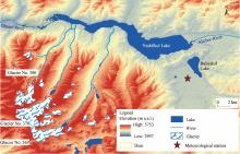
Fig. 1.
Location of Yashilkul and Bulunkul lakes and surrounding glaciers in the eastern Pamir Plateau, Tajikistan. The background elevation is based on Shuttle Radar Topography Mission (SRTM) digital elevation model (DEM) data, downloaded from the Open Topography Portal (https://portal.opentopography.org)."

Table 1
Satellite and unmanned aerial vehicle (UAV) data used in this study."
| Purpose | Date | Product name | Resolution | Source |
|---|---|---|---|---|
| Glacier and lake area mapping | 1 September 1994 | Landsat 5 TM | 30 m×30 m | U.S. Geological Survey EROS Centre ( |
| 24 August 2000 | Landsat 7 ETM+ | 15 m×15 m | ||
| 22 August 2005 | Landsat 7 ETM+ | 15 m×15 m | ||
| 28 August 2010 | Landsat 5 TM | 30 m×30 m | ||
| 27 August 2015 | Landsat 8 OLI | 15 m×15 m | ||
| 8 September 2020 | Landsat 8 OLI | 15 m×15 m | ||
| 3 September 2024 | Landsat 8 OLI | 15 m×15 m | ||
| Visual observation | 11 June 2022 | DJI Phantom 4 | - | UAV field survey |
| Lake area mapping and dam morphology checking | 30 June 2024 | Micro UAV QC-2 | 26 cm×26 cm | UAV field survey |
| Topography determining | 2000 | SRTM v3 DEM | 30 m×30 m | NASA ( |
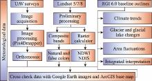
Fig. 2.
Methodology workflow for glacier and lake changes. UAV, unmanned aerial vehicle; NDWI, normalized difference water index; NDSI, normalized difference snow index; RGI, Randolph Glacier Inventory."
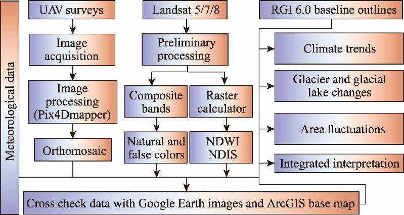
Table 2
Statistical trend analysis results."
| Parameter | Sen’s slope | P-value | τ | Autocorrelation |
|---|---|---|---|---|
| Annual mean temperature | 0.096°C/a | <0.001 | 0.353 | 0.675 |
| Spring temperature | 0.151°C/a | <0.001 | - | - |
| Summer temperature | 0.114°C/a | <0.001 | - | - |
| Winter temperature | 0.060°C/a | 0.002 | - | - |
| Annual precipitation | -0.300 mm/a | 0.169 | -0.067 | 0.042 |
| Summer precipitation | -0.057 mm/a | 0.734 | - | - |
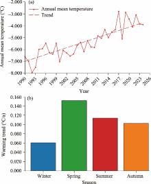
Fig. 3.
Annual mean temperature (a) and seasonal temperature trend (b) at Bulunkul meteorological station during 1990-2024 with the modified Mann-Kendal test."

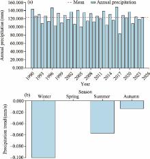
Fig. 4.
Annual precipitation (a) and seasonal precipitation trend (b) at Bulunkul meteorological station during 1990-2024."
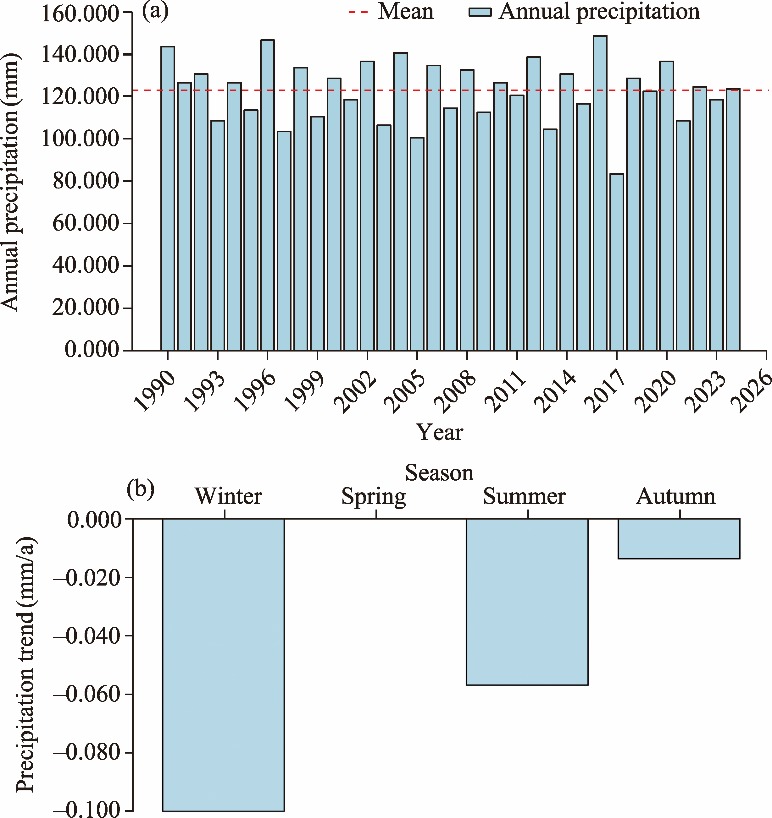
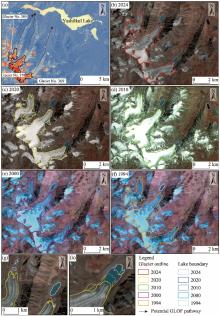
Fig. 5.
Glacier and proglacial lake dynamics in the western Yashilkul Basin from 1994 to 2024. (a), overview map of glaciers (including Glacier No. 369, Glacier No. 378, and Glacier No. 380), glacial lakes, and inferred flow paths from glacial sources toward the Yashilkul Lake; (b-f), Landsat imagery in 2024, 2020, 2010, 2000, and 1994 with glacier outlines and lake boundaries, respectively; (g and h), zoomed images from 2024 displaying close-up views of glacier termini and adjacent lakes, respectively. The multi-temporal outlines indicate notable glacier retreat and expansion of proglacial lakes during the 31 a. The arrows in figure a indicate the potential glacial lake outburst flood (GLOF) pathways, highlighting hazard linkage between upstream glacial systems and downstream Yashilkul Lake."

Table 3
Changes in representative glaciers in the Yashilkul Basin during 1994-2024."
| Glacier No. | Area in 1994 (km2) | Area in 2024 (km2) | Area change (%) | Note |
|---|---|---|---|---|
| 369 | 6.34±0.27 | 5.95±0.12 | -6.09 | Strong retreat, proglacial-lake contact, and about 860 m frontal retreat |
| 378 | 9.79±0.32 | 9.67±0.17 | -1.28 | Land-terminating glacier and stable front |
| 380 | 4.63±0.27 | 4.54±0.13 | -2.10 | Small cirque glacier and limited change |
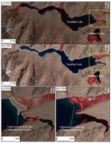
Fig. 6.
Multi-temporal satellite imageries indicating changes in Yashilkul Lake between 1994 and 2024. (a and b), full-lake views obtained in 2024 and 1994, utilizing Landsat images, respectively; (c and d), zoomed-in views of the northern part of the lake, underscoring the reduction in the extent of surface water in 2024 and 1994, respectively."
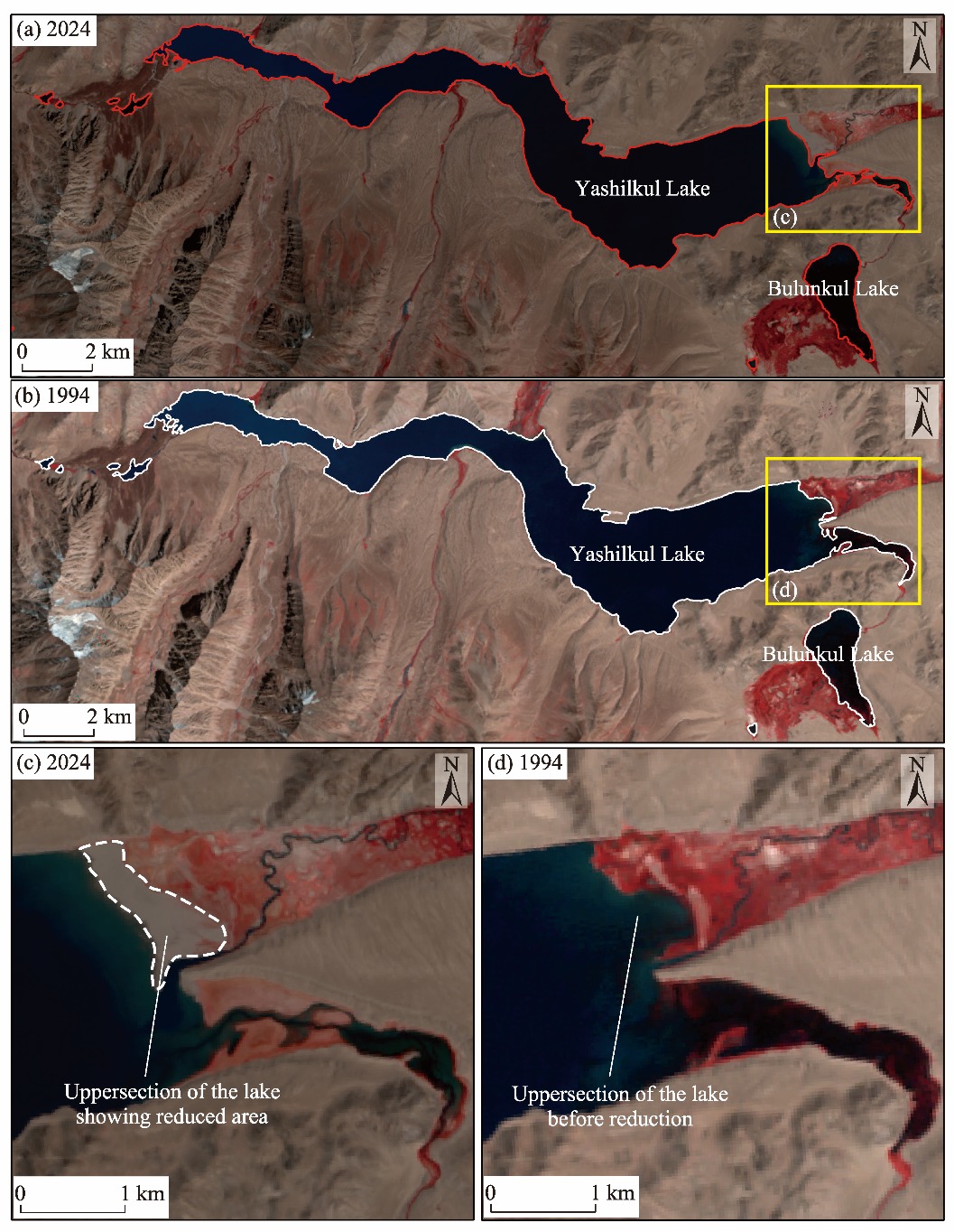
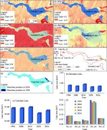
Fig. 7.
Spatiotemporal dynamics of the Yashilkul Lake and its surrounding lakes in the Pamir Plateau derived from Landsat imagery employing the normalized difference water index (NDWI). (a-e), NDWI distribution of the Yashilkul Lake in 2024, 2020, 2010, 2000, and 1994, respectively; (f), lake area changes over time for the Yashilkul and Bulunkul lakes; (g), shoreline positions of the Yashilkul Lake in 1994 and 2024; (h and i), bar charts illustrating the lake area variations of the Bulunkul and Yashilkul lakes from 1994 to 2024, respectively; (j), bar chart summarizing area variations of other surrounding lakes (including Lake No. a1, Lake No. a2, Lake No. a3, Lake No. a4, and Lake No. a7) from 1994 to 2024."


Fig. 8.
UAV-based visual survey of the dam of the Yashilkul Lake and its surrounding lakes conducted in 2022. (a), overview of the natural dam formed by a rockslide, displaying the artificial canal and downstream Lake No. a4; (b), left-bank slope, interpreted as landslide source area, with rockfall path leading to dam body; (c), oblique view of upstream lakes (Lake No. a1-Lake No. a4) located within and behind the dam structure, formed due to the obstruction of the Ghund River; (d), a close-up of the dam’s surface material, revealing typical angular rubble and boulder-sized rocks; scale is provided by included a person."

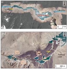
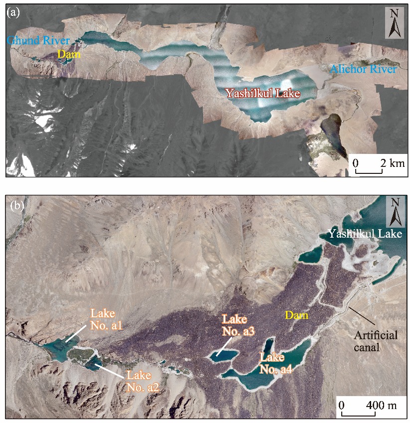
Fig. 9.
High-resolution UAV orthomosaic of the entire Yashilkul Lake obtained in 2024. (a), full lake overview, displaying inflows from the Alichor and Ghund rivers, the tectonic lake basin, and the dammed western end; (b), detailed view of the natural landslide dam, upstream lakes (Lake No. a1-Lake No. a4), and artificial canal directing water into the Ghund River."
| [1] | Ali S., Saeed A., Kiani R.S., et al., 2021. Future climatic changes, extreme events, related uncertainties, and policy recommendations in the Hindu Kush sub-regions of Pakistan. Theoretical and Applied Climatology. 143, 193-209. |
| [2] | Banerjee A., Kang S.C., Guo W.Q., et al., 2024. Glacier retreat and lake outburst floods in the central Himalayan region from 2000 to 2022. Natural Hazards. 120, 5485-5508. |
| [3] | Banerjee A., Meadows E.M., Yadav N., et al., 2025. Glacier and glacial lake dynamics from 1990 to 2024 and their impact on flood hazard in the central Nepal Himalaya. Journal of Mountain Science. 22, 1926-1943. |
| [4] | Beniston M., 2003. Climatic change in mountain regions: A review of possible impacts. Climatic Change. 59, 5-31. |
| [5] | Camassa R., Eidam E.F., Leve L.G., et al., 2023. Extreme seasonal water-level changes and hydraulic modeling of deep, high-altitude, glacial-carved, Himalayan lakes. Scientific Reports. 13, 11705, doi: 10.1038/s41598-023-37667-z. |
| [6] | Compagno L., Huss M., Zekollari H., et al., 2022. Future growth and decline of high mountain Asia’s ice-dammed lakes and associated risk. Communications Earth & Environment. 3, 191, doi: 10.1038/s43247-022-00520-8. |
| [7] | Debnath M., Sharma M.C, Syiemlieh J., 2019. Glacier dynamics in Changme Khangpu basin, Sikkim Himalaya, India, between 1975 and 2016. Geosciences. 9(6), 259, doi: 10.3390/geosciences9060259. |
| [8] |
Fallah B., Didovets I., Rostami M., et al., 2024. Climate change impacts on Central Asia: Trends, extremes and future projections. International Journal of Climatology. 44(10), 3191-3213.
doi: 10.1002/joc.v44.10 |
| [9] | Farinotti D., Immerzeel W.W., de Kok R.J., et al., 2020. Manifestations and mechanisms of the Karakoram glacier Anomaly. Nature Geoscience. 13, 8-16. |
| [10] | Filipović S., Orlov A., Panić A.A., 2024. Key forecasts and prospects for green transition in the region of Central Asia beyond 2022. Energy, Sustainability and Society. 14, 25, doi: 10.1186/s13705-024-00457-0. |
| [11] |
Furian W., Loibl D., Schneider C., 2021. Future glacial lakes in High Mountain Asia: an inventory and assessment of hazard potential from surrounding slopes. Journal of Glaciology. 67(264), 653-670.
doi: 10.1017/jog.2021.18 |
| [12] |
Gardelle J., Berthier E., Arnaud Y., et al., 2013. Region-wide glacier mass balances over the Pamir-Karakoram-Himalaya during 1999-2011. The Cryosphere. 7(4), 1263-1286.
doi: 10.5194/tc-7-1263-2013 |
| [13] |
Guo W.Q., Liu S.Y., Xu J.L., et al., 2015. The second Chinese glacier inventory: data, methods and results. Journal of Glaciology. 61(226), 357-372.
doi: 10.3189/2015JoG14J209 |
| [14] | Han J.Q., Tu R., Lu X.C., et al., 2023. Analysis of BDS/GPS deformation monitoring for the Lake Sarez Dam. Remote Sensing. 15(19), 4773, doi: 10.3390/rs15194773. |
| [15] | Haq F., Shutkin T., Afreen M., et al., 2025. Cryo-social dynamics: the interplay of glacial dynamics and socioeconomic conditions in the Shigar Valley, Karakoram, Pakistan. GeoJournal. 90, 37, doi: 10.1007/s10708-025-11289-6. |
| [16] | He J.P., Duan K.Q., Li S.S., et al., 2024. Northward shift of Indian summer monsoon and intensifying winter westerlies cause stronger precipitation seasonality over Pamirs and its downstream basins in the 21st century. Science of The Total Environment. 926, 171891, doi: 10.1016/j.scitotenv.2024.171891. |
| [17] | Ischuk N., 2013. The origin of the mountain river dams in Tajikistan. In: MargottiniC., CanutiP., SassaK., (LandslideScience and Practice,eds.). Volume 6-Risk Assessment, Management and Mitigation. Heidelberg: Springer, 13-17. |
| [18] | Khojeh S., Ataie-Ashtiani B., Hosseini S.M., 2022. Effect of DEM resolution in flood modeling: a case study of Gorganrood River, Northeastern Iran. Natural Hazards. 112, 2673-2693. |
| [19] | Komatsu T., 2016. Geomorphic features of the eastern Pamirs, with a focus on the occurrence of intermontane basins. In: KreutzmannH., WatanabeT., (MappingTransition in the Pamirs.eds.). Advances in Asian Human-Environmental Research. Cham: Springer, 55-68. |
| [20] |
Li Y.J., Li F., Shangguan D.H., et al., 2021. A new global gridded glacier dataset based on the Randolph Glacier Inventory version 6.0. Journal of Glaciology. 67(264), 773-776.
doi: 10.1017/jog.2021.28 |
| [21] |
Long H., Zhang J.R., Zhang S., et al., 2025. The westerlies-monsoon interaction shaped asymmetric lake expansions over the Tibetan Plateau in warming periods. Science Bulletin. 70(19), 3245-3254.
doi: 10.1016/j.scib.2025.07.023 |
| [22] |
Mergili M., Schneider J.F., 2011. Regional-scale analysis of lake outburst hazards in the southwestern Pamir, Tajikistan, based on remote sensing and GIS. Natural Hazards and Earth System Science. 11(5), 1447-1462.
doi: 10.5194/nhess-11-1447-2011 |
| [23] |
Mergili M., Kopf C., Müllebner B., et al., 2012. Changes of the cryosphere and related geohazards in the high-mountain areas of Tajikistan and Austria: a comparison. Geografiska Annaler: Series A, Physical Geography. 94(1), 79-96.
doi: 10.1111/j.1468-0459.2011.00450.x |
| [24] | Metrak M., Sulwinski M., Chachulski L., et al., 2015. Creeping environmental problems in the Pamir Mountains:Landscape conditions, climate change, wise use and threats. In: ÖztürkM., HakeemK., Faridah-HanumI., et al.eds.)., (Climate Change Impacts on High-Altitude Ecosystems. Cham: Springer, 665-695. |
| [25] | Muhammad S., Tian L., Khan A., 2019. Early twenty-first century glacier mass losses in the Indus Basin constrained by density assumptions. Journal of Hydrology. 574, 467-475. |
| [26] |
Muhammad S., Li J., Steiner J.F., et al., 2021. A holistic view of Shisper Glacier surge and outburst floods: from physical processes to downstream impacts. Geomatics, Natural Hazards Risk. 12(1), 2755-2775.
doi: 10.1080/19475705.2021.1975833 |
| [27] | Mukhabbatov H.М., Zhiltsov S.S., Markova E.A., 2020. Tajikistan water resources and water management issues. In: ZonnI., ZhiltsovS., KostianoyA., et al.eds.)., (Water Resources Management in Central Asia. The Handbook of Environmental Chemistry. Cham: Springer, 111-123. |
| [28] | Murodov M., Li L.H., Safarov M., et al., 2024. A comprehensive examination of the Medvezhiy Glacier’s Surges in West Pamir (1968-2023). Remote Sensing. 16(10), 1730, doi: 10.3390/rs16101730. |
| [29] |
Navruzshoev H., Sagintayev Z., Kabutov H., et al., 2022. Surface area dynamics of Gunt River Basin mountain lakes (Pamir, Tajikistan). Central Asian Journal of Water Research. 8(2), 141-152.
doi: 10.29258/CAJWR/2022-R1.v8-2/141-152.eng |
| [30] | Nie Y., Pritchard H.D., Liu Q., et al., 2021. Glacial change and hydrological implications in the Himalaya and Karakoram. Nature Reviews Earth & Environment. 2, 91-106. |
| [31] | Niyatbekov T.P., 2008. Algoflora of Lake Yashilkul (Eastern Pamir). Representative of the National Academy of Sciences of Tajikistan. 51(12), 844-847. |
| [32] | Nowak A., Nowak S., Nobis M., 2020. The Pamir-Alai Mountains (Middle Asia:Tajikistan). In: NorooziJ., (ed.). Plant Biogeography and Vegetation of High Mountains of Central and South-West Asia. Plant and Vegetation, 17. Cham: Springer, 1-42. |
| [33] |
Pohl E., Knoche M., Gloaguen R., et al., 2015. Sensitivity analysis and implications for surface processes from a hydrological modelling approach in the Gunt catchment, high Pamir Mountains. Earth Surface Dynamics. 3(3), 333-362.
doi: 10.5194/esurf-3-333-2015 |
| [34] |
Pohl E., Gloaguen R., Andermann C., et al., 2017. Glacier melt buffers river runoff in the Pamir Mountains. Water Resources Research. 53(3), 2467-2489.
doi: 10.1002/wrcr.v53.3 |
| [35] | RGI (Randolph Glacier Inventory) Consortium, 2017. A Dataset of Global Glacier Outlines, Version 6. [2025-07-06]. https://www.glims.org/RGI/. |
| [36] |
Rokni K., 2023. Investigating the impact of Pan Sharpening on the accuracy of land cover mapping in Landsat OLI imagery. Geodesy and Cartography. 49(1), 12-18.
doi: 10.3846/gac.2023.15308 |
| [37] | Safarov M., Kang S.C., Fazylov A., et al., 2024a. Estimating glacier dynamics and supraglacial lakes together with associated regional hazards using high-resolution datasets in Pamir. Journal of Mountain Science. 21, 3767-3788. |
| [38] | Safarov M., Kang S.C., Murodov M., et al., 2024b. Quantifying glacier surging and associated lake dynamics in Amu Darya river basin using UAV and remote sensing data. Journal of Mountain Science. 21, 2967-2985. |
| [39] | Scaini C., Tamaro A., Adilkhan B., et al., 2024a. A new regionally consistent exposure database for Central Asia: population and residential buildings. Natural Hazards and Earth System Sciences. 24(3), 929-945. |
| [40] | Scaini C., Tamaro A., Adilkhan B., et al., 2024b. A regional-scale approach to assessing non-residential building, transportation and cropland exposure in Central Asia. Natural Hazards and Earth System Sciences. 24(2), 355-373. |
| [41] |
Schurr B., Ratschbacher L., Sippl C., et al., 2014. Seismotectonics of the Pamir. Tectonics. 33(8), 1501-1518.
doi: 10.1002/tect.v33.8 |
| [42] |
Strom A., 2010. Landslide dams in Central Asia region. Journal of the Japan Landslide Society. 47(6), 309-324.
doi: 10.3313/jls.47.309 |
| [43] | Strom A., 2014. Sarez Lake problem:Ensuring long-term safety. In: SassaK., CanutiP., YinY., (Landslide Science for a Safer Geoenvironment.eds.). Cham: Springer, 633-639. |
| [44] | Strom A., 2015. Natural river damming: Climate-driven or seismically induced phenomena:Basics for landslide and seismic hazard assessment. In: LollinoG., GiordanD., CrostaG.B., (Engineering Geology for Society and Territory - Volume 2. Cham:eds.). Springer, 33-41. |
| [45] |
Treichler D., Kääb A., Salzmann N., et al., 2019. Recent glacier and lake changes in High Mountain Asia and their relation to precipitation changes. The Cryosphere, 13(11), 2977-3005.
doi: 10.5194/tc-13-2977-2019 |
| [46] | Vasil’eva E.D., Nazarov R.A., 2023. Preliminary data indicate a wider distribution of the little-known Karakul Stone Loach Triplophysa lacusnigri (Nemacheilidae) in the inland waters of Tajikistan. Journal of Ichthyology. 63, 869-877. |
| [47] |
Wang H., Wang B.B., Cui P., et al., 2024. Disaster effects of climate change in High Mountain Asia: State of art and scientific challenges. Advances in Climate Change Research. 15(3), 367-389.
doi: 10.1016/j.accre.2024.06.003 |
| [48] | Wang Y.Z., Zheng D.H., Zhang G.Q., et al., 2025. Patterns and change rates of glacial lake water levels across High Mountain Asia. National Science Review. 12(3), nwaf041, doi: 10.1093/nsr/nwaf041. |
| [49] | White C.J., Tanton T.W., Rycroft D.W., 2014. The impact of climate change on the water resources of the Amu Darya Basin in Central Asia. Water Resources Management. 28, 5267-5281. |
| [50] | World Bank, 2004. Tajikistan: Reducing Poverty through Private Infrastructure Services—The Pamir Private Power Project. [2025-07-25]. https://documents1.worldbank.org/curated/en/468511468778533007/pdf/30-7980TJ0Pamir0Power01see0also0307591.pdf. |
| [51] | Ye Q.H., Wang Y.Z., Liu L., et al., 2024. Remote sensing and modeling of the cryosphere in High Mountain Asia: A multidisciplinary review. Remote Sensing. 16(10), 1709, doi: 10.3390/rs16101709. |
| [52] | Yu T., Bao A.M., Xu W.Q., et al., 2020. Exploring variability in landscape ecological risk and quantifying its driving factors in the Amu Darya Delta. International Journal of Environmental Research and Public Health. 17(1), 79, doi: 10.3390/ijerph17010079. |
| [53] | Yue S., Wang C.Y., 2004. The Mann-Kendall Test modified by effective sample size to detect trend in serially correlated hydrological series. Water Resources Management. 18, 201-218. |
| [54] | Zakharov S.G., 2023. Water resources a factor of the geopolitical integration of Russia and the countries of Central Asia. In: BeskopylnyA., ShamtsyanM., ArtiukhV., (XV International Scientific Conference “Interagromash 2022”.eds.). Cham: Springer. doi: 10.1007/978-3-031-21432-5_115. |
| [55] | Zhang D.P., Gu W.B., Esamdin A., et al., 2025. Characteristics of surface temperature inversion at the Muztagh-Ata Site on the Pamir Plateau. Atmosphere. 16(8), 897, doi: 10.3390/atmos16080897. |
| [1] | CHEN Xuanhao, LI Chao, ZHANG Shiqiang. Nonlinear carbon-water coupling in terrestrial ecosystems: Insights from China’s Three-North Shelterbelt Forest region [J]. Regional Sustainability, 2026, 7(2): 100328-. |
| [2] | WEI Susu, ZHANG Yuanyuan, TAO Ye, ZHANG Yue, DAI Ling, Mekhrovar OKHONNIYOZOV, MA Xuexi, LI Yaoming, ZHANG Yuanming. Elevational patterns of plant species and phylogenetic diversity in the eastern Pamir Plateau [J]. Regional Sustainability, 2026, 7(2): 100330-. |
| [3] | Sourakanti SARKAR, Aishi MUKHERJEE, Auindrila BISWAS, Subrata GORAIN, Bimal BERA, Anmol GIRI, Malini ROY CHOUDHURY, Suman DUTTA, Sumanta DAS. Evaluating farmers’ strategies and socioeconomic drivers for adaptation to climate uncertainty: A case study in the Himalayan region of West Bengal, India [J]. Regional Sustainability, 2026, 7(2): 100334-. |
| [4] | CHEN Yaning, FANG Gonghuan, LI Zhi, ZHANG Xueqi, LI Weihong, Nekruz GULAHMADOV, Farhod NASRULLOEV, Aminjon GULAKHMADOV. Water resources and sustainable management in Tajikistan under global change [J]. Regional Sustainability, 2026, 7(1): 100291-. |
| [5] | Kobiljon Khushvakht KHUSHVAKHTZODA, Ilkhom Burkhonovich MAKHSUMOV, Muzaffar Boynazarovich KHOLNAZAROV, Irina Mikhailovna KIRPICHNIKOVA. Impact of green energy development on climate change mitigation [J]. Regional Sustainability, 2026, 7(1): 100292-. |
| [6] | Hikmat HISORIEV, LI Yaoming, HUANG Wenjun, FAN Lianlian, Mekhrovar OKHONNIYOZOV, MA Xuexi. Grassland ecosystems of Tajikistan: Plant species diversity, ecological restoration, and sustainable management [J]. Regional Sustainability, 2026, 7(1): 100293-. |
| [7] | Ranna HAZIHAN, DU Hongru, HE Chuanchuan, Kobiljon Khushvakht KHUSHVAKHTZODA, Bobozoda KOMIL. Coupling dynamics of SDGs in Tajikistan from 2001 to 2023 [J]. Regional Sustainability, 2026, 7(1): 100295-. |
| [8] | XU Chunhai, LI Zhongqin, HE Zhonghua, WANG Feiteng, MU Jianxin, CHEN Yaning, Sheralizoda NAZRIALO, Farhod NASRULLOEV, Aminjon GULAHMADZODA. Current status and recent changes of glaciers in Tajikistan [J]. Regional Sustainability, 2026, 7(1): 100296-. |
| [9] | LI Chunlan, YU Yang, SUN Lingxiao, HE Jing, LU Yuanbo, GUO Zengkun, FANG Gonghuan, Alexandr ULMAN, Vitaliy SALNIKOV, Ireneusz MALIK, Małgorzata WISTUBA. Spatiotemporal heterogeneity of runoff in Tajikistan and its driving mechanisms under climate change [J]. Regional Sustainability, 2026, 7(1): 100297-. |
| [10] | LI Yupeng, CHEN Yaning, WANG Fei, ZHANG Xiang, ZHANG Qifei, SUN Fan, FANG Gonghuan, Safarkhon SHAROFIDDINOV, Jafar NIYAZOV. Risks of snow drought and impacts on streamflow in Tajikistan [J]. Regional Sustainability, 2026, 7(1): 100298-. |
| [11] | Nasrulloev FARHOD, CHEN Yaning, Sheralizoda NAZRIALO, Gulahmadov NEKRUZ, Shobairi SEYED OMID REZA, Murodov MURODKHUJA. Hydrological change trends of the Surkhob and Khingov river basins in the Vakhsh River of Tajikistan under climate change [J]. Regional Sustainability, 2026, 7(1): 100300-. |
| [12] | Mahalingam Santhosh KUMAR, Narasimabhrathi Venkatesa PALANICHAMY, K. M. SHIVAKUMAR, Mani CHANDRAKUMAR, Muthuswamy KALPANA, Dhandapani MURUGANANTHI. Impact of climate change on global economy: A comprehensive review [J]. Regional Sustainability, 2025, 6(6): 100274-. |
| [13] | Yadeta BEDASA, Adeba GEMECHU, Amsalu BEDEMO. Combined adoption decisions of climate-smart agriculture and their impacts on maize yield in western Ethiopia [J]. Regional Sustainability, 2025, 6(6): 100280-. |
| [14] | Md Tauhid Ur RAHMAN, Adnan KHAIRULLAH. Integrating farmers’ perceptions and empirical climate data to assess agricultural productivity and food security in coastal Bangladesh [J]. Regional Sustainability, 2025, 6(5): 100259-. |
| [15] | Piyali KUMAR. Examining the effects of climatic and non-climatic factors on sectoral growth: Evidence from different country income groups [J]. Regional Sustainability, 2025, 6(5): 100261-. |
| Viewed | ||||||
|
Full text |
|
|||||
|
Abstract |
|
|||||
 REGSUS Wechat
 新公网安备 65010402001202号