Regional Sustainability ›› 2026, Vol. 7 ›› Issue (3): 100351.doi: 10.1016/j.regsus.2026.100351
• Research article • Previous Articles Next Articles
WANG Xinyuana,b, LI Fujiaa,*( ), CHENG Haoa, Kirill GANZEYc, Dashtseren AVIRMEDd, ZHAO Ruofana,b, CHEN Lia,b, LEI Aohana,b
Received:2025-04-24
Revised:2026-01-16
Accepted:2026-05-07
Published:2026-06-30
Online:2026-05-22
Contact:
*E-mail address: lifj@igsnrr.ac.cn (LI Fujia).
WANG Xinyuan, LI Fujia, CHENG Hao, Kirill GANZEY, Dashtseren AVIRMED, ZHAO Ruofan, CHEN Li, LEI Aohan. Changes of ecological vulnerability under different wetland change patterns: A case study of the transboundary Heilongjiang (Amur) River Basin[J]. Regional Sustainability, 2026, 7(3): 100351.
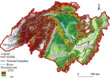
Fig. 1.
Scope and elevation distribution of the Heilongjiang (Amur) River Basin (HARB) region. Note that the figure is based on the standard map (GS(2021)5443) from the Map Service System (http://bzdt.ch.mnr.gov.cn/download.html) issued by the Ministry of Natural Resources of the People’s Republic of China, and the boundary of the standard map has not been modified."

Table 1
Sources and details of the data utilized in this study."
| Data name | Data source | Resolution | Time | Usage |
|---|---|---|---|---|
| Building area | Global Human Settlement (GHS) built-up surface grid (R2023) (Pesaresi et al., | 1000 m | 1990, 2000, 2010, and 2020 | Building density |
| Population | GHS population grid (R2023) (Pesaresi et al., | 1000 m | 1990, 2000, 2010, and 2020 | Population density |
| Precipitation | Terra Climate (Abatzoglou et al., | About 4638 m | Per month from 1980 to 2020 | Extreme drought, extreme humidity, and soil conservation amount |
| Drought | Terra Climate (Abatzoglou et al., | About 4638 m | 1990, 2000, 2010, and 2020 | Palmer drought index (PDI) |
| Digital elevation model (DEM) | 2020 Space Shuttle Radar Topographic Mission (SRTM) (Jarvis et al., | 90 m | / | Elevation, terrain relief, and slope |
| Normalized difference vegetation index (NDVI) | The National Oceanic and Atmospheric Administration Climate Data Record of Advanced Very High Resolution Radiometer NDVI (Vermote and NOAA CDR Program, | About 5566 m | 1990, 2000, 2010, and 2020 | Fractional vegetation cover (FVC) |
| Net primary productivity (NPP) | National Ecological Science Data Center (Chen et al., | About 7000 m | 1990, 2000, 2010, and 2019 | NPP |
| Soil erodibility (K) factor | European Soil Data Centre (Gupta et al., | 1000 m | / | Soil conservation amount |
| Land use | European Space Agency Climate Change Initiative Land Cover program (Copernicus Climate Change Service, | 300 m | 1992, 2000, 2010, and 2020 | Habitat quality index (HQI) |
| Protected area distribution | The World Database on Protected Areas ( | Vector data | 1990, 2000, 2010, and 2020 | Proportion of protected areas |
| Wetland distribution | A global wetland map with a detailed classification system at a 30-m resolution (Zhang et al., | 30 m | 2000, 2005, 2010, 2015, and 2020 | Wetland change patterns |
| Scope of Heilongjiang (Amur) River Basin (HARB) | Global Change Research Data Publishing & Repository (Huang et al., | Vector data | / | Study area |
| Scope of sub-basin of HARB | HydroBASINS (Lehner and Grill, | Vector data | / | Proportion of protected areas |
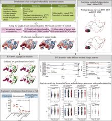
Fig. 2.
Schematic illustration of the analytical workflow employed in this study. AHP, Analytic Hierarchy Process; CRITIC, Criteria Importance Through Intercriteria Correlation; EVI, ecological vulnerability index."

Table 2
Selected indicators for ecological vulnerability in the HARB and their corresponding weights."
| Primary goal | General criteria (weight) | Specific criteria (weight) | Direction |
|---|---|---|---|
| Ecological vulnerability | Exposure (0.392) | Building density (0.108) | + |
| Population density (0.102) | + | ||
| Extreme drought (0.056) | + | ||
| Extreme humidity (0.065) | + | ||
| PDI (0.061) | + | ||
| Sensitivity (0.417) | Elevation (0.056) | + | |
| Terrain relief (0.026) | + | ||
| Slope (0.041) | + | ||
| FVC (0.070) | - | ||
| NPP (0.091) | - | ||
| Soil conservation amount (0.133) | - | ||
| Adaptability (0.191) | HQI (0.107) | - | |
| Proportion of protected areas (0.084) | - |
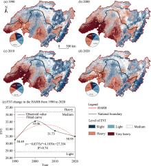
Fig. 3.
Spatial and temporal distributions of EVI in the HARB from 1990 to 2020. (a), EVI of the HARB in 1990; (b), EVI of the HARB in 2000; (c), EVI of the HARB in 2010; (d), EVI of the HARB in 2020; (e), EVI change in the HARB from 1990 to 2020. The pie charts in panels (a)-(d) represent the area percentage of different EVI levels for each corresponding year. Note that the figure is based on the standard map (GS(2021)5443) from the Map Service System (http://bzdt.ch.mnr.gov.cn/download.html) issued by the Ministry of Natural Resources of the People’s Republic of China, and the boundary of the standard map has not been modified."

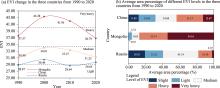
Fig. 4.
EVI change and average area percentage of different EVI levels in the three countries from 1990 to 2020. (a), EVI change in the three countries from 1990 to 2020; (b), average area percentage of different EVI levels in the three countries from 1990 to 2020."

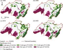
Fig. 5.
EVI space aggregation situation in 1990 (a), 2000 (b), 2010 (c), and 2020 (d). Note that the figure is based on the standard map (GS(2021)5443) from the Map Service System (http://bzdt.ch.mnr.gov.cn/download.html) issued by the Ministry of Natural Resources of the People’s Republic of China, and the boundary of the standard map has not been modified."

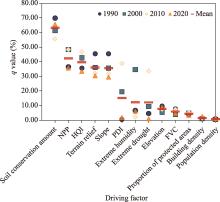
Fig. 6.
Impact of various driving factors on EVI changes across different years. q value represents the factor explanatory power."

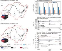
Fig. 7.
Impacts of wetland change patterns on EVI from 2000 to 2020, along with the spatial distribution of the three wetland change patterns (expansion, stable, and degradation) during 2000-2010 and 2010-2020. (a), wetland change from 2000 to 2010; (b), wetland change from 2010 to 2020; (c), area of wetland in the HARB from 2000 to 2020; (d), trend of mean EVI for wetland and non-wetland areas from 2000 to 2020; (e), trend of mean EVI for wetland and non-wetland areas in China and Russia from 2000 to 2020. The pie charts in panels (a) and (b) represent the area percentage of three wetland change patterns for each corresponding year. Note that the figure is based on the standard map (GS(2021)5443) from the Map Service System (http://bzdt.ch.mnr.gov.cn/download.html) issued by the Ministry of Natural Resources of the People’s Republic of China, and the boundary of the standard map has not been modified."

Table 3
Mean values and change values of EVI under different wetland change patterns."
| Region | Wetland change pattern | Mean value of EVI | Change value of EVI | ||
|---|---|---|---|---|---|
| 2000-2010 | 2010-2020 | 2000-2010 | 2010-2020 | ||
| HARB | Expansion | 34.98 | 34.90 | 0.00 | 0.29 |
| Stable | 34.26 | 34.76 | -0.31 | 0.28 | |
| Degradation | 33.91 | 34.41 | 0.07 | 0.35 | |
| China | Expansion | 37.35 | 36.87 | 0.36 | -1.23 |
| Stable | 36.15 | 35.87 | 0.36 | -1.19 | |
| Degradation | 36.79 | 36.32 | 0.22 | -1.62 | |
| Russia | Expansion | 33.18 | 33.59 | -0.16 | 1.34 |
| Stable | 33.06 | 33.97 | -0.04 | 1.33 | |
| Degradation | 32.35 | 33.22 | -0.56 | 1.46 | |
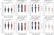
Fig. 8.
Changes of EVI and standardized key indicators across different wetland change patterns during 2000-2010 and 2010-2020. (a), EVI change during 2000-2010; (b), change of standardized extreme drought during 2000-2010; (c), change of standardized extreme humidity during 2000-2010; (d), change of standardized HQI during 2000-2010; (e), EVI change during 2010-2020; (f), change of standardized extreme drought during 2010-2020; (g), change of standardized extreme humidity during 2010-2020; (h), change of standardized HQI during 2010-2020. Yellow point with the horizontal line indicates the median value of each factor. The rectangle represents the range that contains the middle 50.00% of the data. The vertical line extending from the rectangle shows the overall spread of the data from lower to higher values. The width of the violin reflects the data density, with wider sections indicating a higher concentration of values. Statistical significance is denoted by asterisks: *** for P<0.001 level, ** for P<0.010 level, * for P<0.050 level, and ns (not significant) for P>0.050 level."

| [1] | Abatzoglou, J.T., Dobrowski, S.Z., Parks, S.A., et al., 2018. TerraClimate, a high-resolution global dataset of monthly climate and climatic water balance from 1958-2015. Scientific Data. 5(1), 170191, doi: 10.1038/sdata.2017.191. |
| [2] | Abdenour, A., Sinan, M., Lekhlif, B., 2025. Toward sustainable wetland management: A literature review of global wetland vulnerability assessment techniques in the context of rising pressures. Sustainability. 17(17), 7962, doi: 10.3390/su17177962. |
| [3] | Anselin, L., 1988. Spatial Econometrics:Methods and Models. Dordrecht: Springer Science & Business Media, 1-284. |
| [4] | Bao, T., Jia, G.S., Xu, X.Y., 2021. Wetland heterogeneity determines methane emissions: A pan-arctic synthesis. Environmental Science & Technology. 55(14), 10152-10163. |
| [5] | Beroya-Eitner, M.A., 2016. Ecological vulnerability indicators. Ecological Indicators. 60, 329-334. |
| [6] | Brinson, M.M., Malvárez, A.I., 2002. Temperate freshwater wetlands: types, status, and threats. Environmental Conservation. 29(2), 115-133. |
| [7] | Chang, X.Y., Yu, L.X., Li, G.S., et al., 2023. Wetland vegetation cover changes and its response to climate changes across Heilongjiang-Amur River Basin. Frontiers in Plant Science. 14, 1169898, doi: 10.3389/fpls.2023.1169898. |
| [8] | Chen, H., Meng, F., Yu, Z.N., et al., 2022. Spatial-temporal characteristics and influencing factors of farmland expansion in different agricultural regions of Heilongjiang Province, China. Land Use Policy. 115, 106007, doi: 10.1016/j.landusepol.2022.106007. |
| [9] | Chen, J., Yu, L.X., Yan, F.Q., et al., 2020. Ecosystem service loss in response to agricultural expansion in the small Sanjiang Plain, Northeast China: Process, driver and management. Sustainability. 12(6), 2430, doi: 10.3390/su12062430. |
| [10] | Chen, J.M., Ju, W.M., Ciais, P., et al., 2019. Vegetation structural change since 1981 significantly enhanced the terrestrial carbon sink. Nature Communications. 10(1), 4259, doi: 10.1038/s41467-019-12257-8. |
| [11] | Chen, T., Bao, A.M., Guo, H., et al., 2019. Ecological vulnerability assessment for a transboundary basin in Central Asia and its spatiotemporal characteristics analysis: Taking Amu Darya River Basin as an example. Journal of Natural Resources. 34(12), 2643-2657 (in Chinese). |
| [12] | Copernicus Climate Change Service, 2019. Land Cover Classification Gridded Maps from 1992 to Present Derived from Satellite Observation. [2025-03-23]. https://doi.org/10.24381/cds.006f2c9a. |
| [13] | Ershadi, A., McCabe, M.F., Evans, J.P., et al., 2013. Effects of spatial aggregation on the multi-scale estimation of evapotranspiration. Remote Sensing of Environment. 131, 51-62. |
| [14] | Erwin, K.L., 2009. Wetlands and global climate change: the role of wetland restoration in a changing world. Wetlands Ecology and Management. 17(1), 71-84. |
| [15] | Field, C.B., Behrenfeld, M.J., Randerson, J.T., et al., 1998. Primary production of the biosphere: Integrating terrestrial and oceanic components. Science. 281(5374), 237-240. |
| [16] | Foley, J.A., DeFries, R., Asner, G.P., et al., 2005. Global consequences of land use. Science. 309(5734), 570-574. |
| [17] | Galatowitsch, S.M., 2018. Natural and anthropogenic drivers of wetland change. In: Finlayson, C.M., Milton, G.R., Prentice, R.C., et al., (eds.). The Wetland Book. Dordrecht: Springer, 359-367. |
| [18] | Gardner, R.C., Finlayson, C., 2018. Global wetland outlook:state of the world’s wetlands and their services to people. In: Ramsar Convention Secretariat. Gland, Switzerland. |
| [19] | Gómez-Baggethun, E., Tudor, M., Doroftei, M., et al., 2019. Changes in ecosystem services from wetland loss and restoration: An ecosystem assessment of the Danube Delta (1960-2010). Ecosystem Services. 39, 100965, doi: 10.1016/j.ecoser.2019.100965. |
| [20] | Gupta, S., Borrelli, P., Panagos, P., et al., 2024. An advanced global soil erodibility (K) assessment including the effects of saturated hydraulic conductivity. Science of The Total Environment. 908, 168249, doi: 10.1016/j.scitotenv.2023.168249. |
| [21] | Han, J., Dai, H., Gu, Z.L., 2021. Sandstorms and desertification in Mongolia, an example of future climate events: a review. Environmental Chemistry Letters. 19(6), 4063-4073. |
| [22] | Harris, B.D., Day, D.J., Cadigan, J.A., et al., 2021. Establishment of soil strength in a nourished wetland using thin layer placement of dredged sediment. PLoS ONE. 16(5), e0251420, doi: 10.1371/journal.pone.0251420. |
| [23] | Haruyama, S., Shiraiwa, T., 2014. Environmental Change and the Social Response in the Amur River Basin. Berlin/Heidelberg: Springer. |
| [24] | Huang, F.Y., Li, T.J., Li, E.Z., et al., 2016. Boundary data of the Amur River Basin. Journal of Global Change Data Discovery. 1(1), 114, doi: 10.3974/geodp.2017.01.18 (in Chinese). |
| [25] | Innocent, M.O., Samuel, J.O., Abdulsalam, M., et al., 2025. Ecosystem structure and formation of wetland. In: Babaniyi, B.R., Aransiola, S.A., Babaniyi, E.E., et al., (eds.). Wetland Ecosystems: Conservation Strategies, Policy Management and Applications. Cham: Springer Nature Switzerland, 3-22. |
| [26] | Inostroza, L., Palme, M., de la Barrera, F., 2016. A heat vulnerability index: Spatial patterns of exposure, sensitivity and adaptive capacity for Santiago de Chile. PLoS ONE. 11(9), e0162464, doi: 10.1371/journal.pone.0162464. |
| [27] | IPCC (Intergovernmental Panel on Climate Change), 2001. Technical summary. In: White, K.S., Ahmad, Q.K., Anisimov, Q., et al., (eds.). Climate Change 2001: Impacts, Adaptation, and Vulnerability. Contribution of Working Group II to the Third Assessment Report of the Intergovernmental Panel on Climate Change. Cambridge: Cambridge University Press. |
| [28] | Ippolito, A., Sala, S., Faber, J.H., et al., 2010. Ecological vulnerability analysis: A river basin case study. Science of The Total Environment. 408(18), 3880-3890. |
| [29] | Jarvis, A., Reuter, H.I., Nelson, A., et al., 2008. Hole-filled SRTM for the Globe Version 4. [2025-03-10]. https://srtm.csi.cgiar.org. |
| [30] | Jeganathan, C., Dash, J., Atkinson, P.M., 2014. Remotely sensed trends in the phenology of northern high latitude terrestrial vegetation, controlling for land cover change and vegetation type. Remote Sensing of Environment. 143, 154-170. |
| [31] | Jia, H.C., Pan, D.H., Zhang, W.C., 2015. Health assessment of wetland ecosystems in the Heilongjiang River Basin, China. Wetlands. 35(6), 1185-1200. |
| [32] | Jia, M.M., Mao, D.H., Wang, Z.M., et al., 2020. Tracking long-term floodplain wetland changes: A case study in the China side of the Amur River Basin. International Journal of Applied Earth Observation and Geoinformation. 92, 102185, doi: 10.1016/j.jag.2020.102185. |
| [33] | Jia, S.Z., Yang, Y.P., 2023. Spatiotemporal characteristics and driving factors of land-cover change in the Heilongjiang (Amur) River Basin. Remote Sensing. 15(15), 3730, doi: 10.3390/rs15153730. |
| [34] | Jiang, L., Huang, X.X., Wang, F.T., et al., 2018. Method for evaluating ecological vulnerability under climate change based on remote sensing: A case study. Ecological Indicators. 85, 479-486. |
| [35] | Jiang, W.G., Lv, J.X., Wang, C.C., et al., 2017. Marsh wetland degradation risk assessment and change analysis: A case study in the Zoige Plateau, China. Ecological Indicators. 82, 316-326. |
| [36] | Jin, F.M., Yang, W.C., Fu, J.X., et al., 2021. Effects of vegetation and climate on the changes of soil erosion in the Loess Plateau of China. Science of The Total Environment. 773, 145514, doi: 10.1016/j.scitotenv.2021.145514. |
| [37] | Johnson, J.M., Clarke, K.C., 2021. An area preserving method for improved categorical raster resampling. Cartography and Geographic Information Science. 48(4), 292-304. |
| [38] | Krankina, O.N., Dixon, R.K., 1994. Forest management options to conserve and sequester terrestrial carbon in the Russian Federation. World Resources. 6(1), 88-101. |
| [39] | Krishnan, A., Mat Kasim, M., Hamid, R., et al., 2021. A modified CRITIC method to estimate the objective weights of Decision Criteria. Symmetry. 13(6), 973, doi: 10.3390/sym13060973. |
| [40] | Kumari, S., Kumar, V., 2025. Wetlands: crucial ecosystem service providers: A contemporary review. International Journal of Science and Research Archive. 14(2), 64-67. |
| [41] | Kundu, S., Pal, S., Talukdar, S., et al., 2021. Impact of wetland fragmentation due to damming on the linkages between water richness and ecosystem services. Environmental Science and Pollution Research. 28(36), 50266-50285. |
| [42] | Lal, R., 1998. Soil erosion impact on agronomic productivity and environment quality. Critical Reviews in Plant Sciences. 17(4), 319-464. |
| [43] | Lehner, B., Grill, G., 2013. Global river hydrography and network routing: baseline data and new approaches to study the world’s large river systems. Hydrological Processes. 27(15), 2171-2186. |
| [44] | Li, A.N., Wang, A.S., Liang, S.L., et al., 2006. Eco-environmental vulnerability evaluation in mountainous region using remote sensing and GIS—A case study in the upper reaches of Minjiang River, China. Ecological Modelling. 192(1-2), 175-187. |
| [45] | Li, B., Wan, R.R., Yang, G.S., et al., 2024. Centennial loss of lake wetlands in the Yangtze Plain, China: Impacts of land use changes accompanied by hydrological connectivity loss. Water Research. 256, 121578, doi: 10.1016/j.watres.2024.121578. |
| [46] | Li, H.Y., Mao, D.H., Li, X.Y., et al., 2022. Understanding the contrasting effects of policy-driven ecosystem conservation projects in northeastern China. Ecological Indicators. 135, 108578, doi: 10.1016/j.ecolind.2022.108578. |
| [47] | Li, J.Y., Wang, R.X., Huang, Q.W., et al., 2025. Climate warming-induced hydrological regime shifts in Cold Northeast Asia: Insights from the Heilongjiang-Amur River Basin. Land. 14(5), 980, doi: 10.3390/land14050980. |
| [48] | Liao, C., Jung, S.Y., Brown, D.G., et al., 2020. Spatial patterns of large‐scale land transactions and their potential socio‐environmental outcomes in Cambodia, Ethiopia, Liberia, and Peru. Land Degradation & Development. 31(10), 1241-1251. |
| [49] | Liu, J.L., Dou, X.Y., Zhang, L., et al., 2024. Differences in anthropogenic impacts of Typical Mid- to High-Latitude Wetlands in the Heilongjiang Basin. Sustainability. 16(20), 9020, doi: 10.3390/su16209020. |
| [50] | Liu, Y.S., Zhou, Y., 2021. Territory spatial planning and national governance system in China. Land Use Policy. 102, 105288, doi: 10.1016/j.landusepol.2021.105288. |
| [51] | Lu, H.Y., Sun, G.L., Li, L., et al., 2020. Ecological vulnerability assessment in Xinjiang based on VSD model. Xinjiang Agricultural Sciences. 57(2), 292-302 (in Chinese). |
| [52] | Lu, M., Xiao, Z., 2024. Wetland ecology and climate change: Addressing global challenges with countermeasures. Advances in Resources Research. 4(1), 67-88. |
| [53] | Luo, M.Y., Jia, X., Zhao, Y.H., et al., 2024. Ecological vulnerability assessment and its driving force based on ecological zoning in the Loess Plateau, China. Ecological Indicators. 159, 111658, doi: 10.1016/j.ecolind.2024.111658. |
| [54] | Malekmohammadi, B., Jahanishakib, F., 2017. Vulnerability assessment of wetland landscape ecosystem services using driver-pressure-state-impact-response (DPSIR) model. Ecological Indicators. 82, 293-303. |
| [55] | Mao, D.H., Luo, L., Wang, Z.M., et al., 2018. Conversions between natural wetlands and farmland in China: A multiscale geospatial analysis. Science of The Total Environment. 634, 550-560. |
| [56] | Mao, D.H., Tian, Y.L., Wang, Z.M., et al., 2021. Wetland changes in the Amur River Basin: Differing trends and proximate causes on the Chinese and Russian sides. Journal of Environmental Management. 280, 111670, doi: 10.1016/j.jenvman.2020.111670. |
| [57] | McGarigal, K., 1995. FRAGSTATS: spatial pattern analysis program for quantifying landscape structure. In: US Department of Agriculture, Forest Service, Pacific Northwest Research Station. Washington, USA. |
| [58] | Moran, P.A.P., 1948. The interpretation of statistical maps. Journal of the Royal Statistical Society: Series B (Methodological). 10(2), 243-251. |
| [59] | Moreno-Mateos, D., Power, M.E., Comín, F.A., et al., 2012. Structural and functional loss in restored wetland ecosystems. PLOS Biology. 10(1), e1001247, doi: 10.1371/journal.pbio.1001247. |
| [60] | Nandintsetseg, B., Boldgiv, B., Chang, J., et al., 2021. Risk and vulnerability of Mongolian grasslands under climate change. Environmental Research Letters. 16(3), 034035, doi: 10.1088/1748-9326/abdb5b. |
| [61] | Nesa, M.M., Propa, S.M., Sen, S., et al., 2024. Land use change and soil erosion:challenges and way forward to management. In: Rahman, M.M., Biswas, J.C., Meena, R.S., (eds.). Climate Change and Soil-Water-Plant Nexus: Agriculture and Environment. Singapore: Springer, 547-571. |
| [62] | Ord, J.K., Getis, A., 2010. Local spatial autocorrelation statistics: Distributional issues and an application. Geographical Analysis. 27(4), 286-306. |
| [63] | Peng, B.H., Huang, Q.Q., Elahi, E., et al., 2019. Ecological environment vulnerability and driving force of Yangtze River Urban Agglomeration. Sustainability. 11(23), 6623, doi: 10.3390/su11236623. |
| [64] | Pesaresi, M., Schiavina, M., Politis, P., et al., 2024. Advances on the Global Human Settlement Layer by joint assessment of Earth observation and population survey data. International Journal of Digital Earth. 17(1), 136539, doi: 10.1080/17538947.2024.2390454. |
| [65] | Piao, S.L., Nan, H.J., Huntingford, C., et al., 2014. Evidence for a weakening relationship between interannual temperature variability and northern vegetation activity. Nature Communications. 5(1), 5018, doi: 10.1038/ncomms6018. |
| [66] | Piao, S.L., Liu, Q., Chen, A.P., et al., 2019. Plant phenology and global climate change: Current progresses and challenges. Global Change Biology. 25(6), 1922-1940. |
| [67] | Pimentel, D., Harvey, C., Resosudarmo, P., et al., 1995. Environmental and economic costs of soil erosion and conservation benefits. Science. 267(5201), 1117-1123. |
| [68] | Pimentel, D., Kounang, N., 1998. Ecology of soil erosion in ecosystems. Ecosystems. 1(5), 416-426. |
| [69] | Qi, L.L., Lu, M., Uddin, M., et al., 2025. Impacts of land use change on habitat quality and its driving mechanisms in the lake basin of Central Yunnan. Scientific Reports. 15(1), 18318, doi: 10.1038/s41598-025-00577-3. |
| [70] | Renard, K.G., Foster, G.R., Weesies, G.A., 1997. Predicting Soil Erosion by Water: A Guide to Conservation Planning with the Revised Universal Soil Loss Equation (RUSLE). Washington: United States Department of Agriculture. |
| [71] | Shen, Y.Y., Liao, K.C., 2022. An application of analytic hierarchy process and entropy weight method in food cold chain risk evaluation model. Frontiers in Psychology. 13, 825696, doi: 10.3389/fpsyg.2022.825696. |
| [72] | Shi, C.H., Yin, W.Z., Lv, Z.R., et al., 2024. Spatial-temporal evolution of ecosystem service value in Guilin, China from 2000 to 2020: a dual-scale perspective. Remote Sensing. 16(23), 4425, doi: 10.3390/rs16234425. |
| [73] | Shi, F.F., Weaver, D., Zhao, Y.Z., et al., 2019. Toward an ecological civilization: Mass comprehensive ecotourism indications among domestic visitors to a Chinese wetland protected area. Tourism Management. 70, 59-68. |
| [74] | Solangi, G.S., Siyal, A.A., Siyal, P., 2019. Spatiotemporal dynamics of land surface temperature and its impact on the vegetation. Civil Engineering Journal. 5(8), 1753-1763. |
| [75] | Song, K.S., Wang, Z.M., Du, J., et al., 2014. Wetland degradation: its driving forces and environmental impacts in the Sanjiang Plain, China. Environmental Management. 54(2), 255-271. |
| [76] | Song, Y.Z., Wang, J.F., Ge, Y., et al., 2020. An optimal parameters-based geographical detector model enhances geographic characteristics of explanatory variables for spatial heterogeneity analysis: cases with different types of spatial data. GIScience & Remote Sensing. 57(5), 593-610. |
| [77] | Sun, M.Y., Yang, R.J., Li, X.H., et al., 2021. Designing a path for the sustainable development of key ecological function zones: A case study of southwest China. Global Ecology and Conservation. 31, e01840, doi: 10.1016/j.gecco.2021.e01840. |
| [78] | Tang, J., Li, Y., Fu, B.L., et al., 2022. Spatial-temporal changes in the degradation of marshes over the past 67 years. Scientific Reports. 12(1), 6070, doi: 10.1038/s41598-022-10104-3. |
| [79] | Tilman, D., Cassman, K.G., Matson, P.A., et al., 2002. Agricultural sustainability and intensive production practices. Nature. 418(6898), 671-677. |
| [80] | Tong, L.G., Xu, X.L., Fu, Y., et al., 2014. Wetland changes and their responses to climate change in the “Three-River Headwaters” Region of China since the 1990s. Energies. 7(4), 2515-2534. |
| [81] | Turner, B.L., Kasperson, R.E., Matson, P.A., et al., 2003. A framework for vulnerability analysis in sustainability science. Proceedings of the National Academy of Sciences. 100(14), 8074-8079. |
| [82] | Turner, D.P., Cohen, W.B., Kennedy, R.E., 2000. Alternative spatial resolutions and estimation of carbon flux over a managed forest landscape in Western Oregon. Landscape Ecology. 15(5), 441-452. |
| [83] | Turner, R.E., 1997. Wetland loss in the Northern Gulf of Mexico: Multiple working hypotheses. Estuaries. 20(1), 1-13. |
| [84] | United, Nations, 2015. Vulnerability and impact assessment in transboundary river basins. In: United Nations, (ed.). Water and Climate Change Adaptation in Transboundary Basins. New York: United Nations, 55-69. |
| [85] | Van Loon, A.F., 2015. Hydrological drought explained. WIREs Water. 2(4), 359-392. |
| [86] | Vermote, E., NOAA CDR, Program, 2019. NOAA Climate Data Record (CDR) of AVHRR Normalized Difference Vegetation Index (NDVI), Version 5. [2025-12-10]. https://doi.org/10.7289/V5ZG6QH9. |
| [87] | Villa, F., McLeod, H., 2002. Environmental vulnerability indicators for environmental planning and decision-making: Guidelines and applications. Environmental Management. 29(3), 335-348. |
| [88] | Wang, H., 2025. Regional ecological risk assessment for Guangxi (China) based on entropy method and the pressure-capital-vulnerability-response model. Ecological Indicators. 175, 113542, doi: 10.1016/j.ecolind.2025.113542. |
| [89] | Wang, J.F., Zhang, T.L., Fu, B.J., 2016. A measure of spatial stratified heterogeneity. Ecological Indicators. 67, 250-256. |
| [90] | Wang, Q., Yao, Y., Zhao, L., et al., 2023. Enhancing resilience against geological hazards and soil erosion through sustainable vegetation management: A case study in Shaanxi Province. Journal of Cleaner Production. 423, 138687, doi: 10.1016/j.jclepro.2023.138687. |
| [91] | Wang, Z.F., Wang, J.Y., Wang, W.L., et al., 2025. An explanation of the differences in grassland NDVI change in the Eastern Route of the China-Mongolia-Russia Economic Corridor. Remote Sensing. 17(5), 867, doi: 10.3390/rs17050867. |
| [92] | Xi, Y., Peng, S.S., Ciais, P., et al., 2021. Future impacts of climate change on inland Ramsar wetlands. Nature Climate Change. 11(1), 45-51. |
| [93] | Xia, M., Jia, K., Zhao, W.W., et al., 2021. Spatio-temporal changes of ecological vulnerability across the Qinghai-Tibetan Plateau. Ecological Indicators. 123, 107274, doi: 10.1016/j.ecolind.2020.107274. |
| [94] | Xiang, H.X., Wang, Z.M., Mao, D.H., et al., 2020. What did China’s National Wetland Conservation Program Achieve? Observations of changes in land cover and ecosystem services in the Sanjiang Plain. Journal of Environmental Management. 267, 110623, doi: 10.1016/j.jenvman.2020.110623. |
| [95] | Xing, X.G., Liu, Y., Jin, R., et al., 2023. Major role of natural wetland loss in the decline of wetland habitat quality—Spatio-temporal monitoring and predictive analysis. Sustainability. 15(16), 12415, doi: 10.3390/su151612415. |
| [96] | Xu, D.H., Bisht, G., Tan, Z.L., et al., 2024. Climate change will reduce North American inland wetland areas and disrupt their seasonal regimes. Nature Communications. 15(1), 2438, doi: 10.1038/s41467-024-45286-z. |
| [97] | Xu, W.H., Fan, X.Y., Ma, J.G., et al., 2019. Hidden loss of wetlands in China. Current Biology. 29(18), 3065-3071. |
| [98] | Yan, B., Xia, Z.Q., Huang, F., et al., 2016. Climate change detection and annual extreme temperature analysis of the Amur River Basin. Advances in Meteorology. 2016, 6268938, doi: 10.1155/2016/6268938. |
| [99] | Yan, F.Q., Zhang, S.W., 2019. Ecosystem service decline in response to wetland loss in the Sanjiang Plain, Northeast China. Ecological Engineering. 130, 117-121. |
| [100] | Yang, Y., Zhao, N., 2023. Vulnerability assessment of urban agglomerations to the risk of heat waves in China since the 21st century. Environmental Pollution. 336, 122443, doi: 10.1016/j.envpol.2023.122443. |
| [101] | Yuan, F.H., Liu, J.Z., Zuo, Y.J., et al., 2020. Rising vegetation activity dominates growing water use efficiency in the Asian permafrost region from 1900 to 2100. Science of The Total Environment. 736, 139587, doi: 10.1016/j.scitotenv.2020.139587. |
| [102] | Zedler, J.B., Kercher, S., 2005. Wetland resources: status, trends, ecosystem services, and restorability. Annual Review of Environment and Resources. 30(1), 39-74. |
| [103] | Zha, F.L., Liu, C., Shi, R.X., 2016. Elevation cluster dataset covering the Amur River Basin. Digital Journal of Global Change Data Repository. doi: 10.3974/geodb.2016.04.17.V1. |
| [104] | Zhang, H., Lei, S.L., 2012. A structural model of residents’ intention to participate in ecotourism: The case of a wetland community. Tourism Management. 33(4), 916-925. |
| [105] | Zhang, X., Liu, L.Y., Zhao, T.T., et al., 2023. GWL_FCS30: a global 30 m wetland map with a fine classification system using multi-sourced and time-series remote sensing imagery in 2020. Earth System Science Data. 15(1), 265-293. |
| [106] | Zhang, X.Q., Wang, L.K., Fu, X.S., et al., 2017. Ecological vulnerability assessment based on PSSR in Yellow River Delta. Journal of Cleaner Production. 167, 1106-1111. |
| [107] | Zhang, X.Y., Liu, K., Wang, S.D., et al., 2022. Spatiotemporal evolution of ecological vulnerability in the Yellow River Basin under ecological restoration initiatives. Ecological Indicators. 135, 108586, doi: 10.1016/j.ecolind.2022.108586. |
| [108] | Zhao, D., He, H.S., Wang, W.J., et al., 2018. Predicting wetland distribution changes under climate change and human activities in a mid- and high-latitude region. Sustainability. 10(3), 863, doi: 10.3390/su10030863. |
| [109] | Zhao, M.S., Running, S.W., 2010. Drought-induced reduction in global terrestrial net primary production from 2000 through 2009. Science. 329(5994), 940-943. |
| [1] | Nasrulloev FARHOD, CHEN Yaning, Sheralizoda NAZRIALO, Gulahmadov NEKRUZ, Shobairi SEYED OMID REZA, Murodov MURODKHUJA. Hydrological change trends of the Surkhob and Khingov river basins in the Vakhsh River of Tajikistan under climate change [J]. Regional Sustainability, 2026, 7(1): 100300-. |
| [2] | Osman ZAKARI, Charles GYAMFI, Samuel Anim OFOSU, Ebenezer BOAKYE, Solomon Tawiah APAFO, Geophrey Kwame ANORNU, Bernard Nuoleyeng BAATUUWIE. Effects of land use and land cover changes on ecosystem services and functions in the Kulpawn River Basin of Ghana [J]. Regional Sustainability, 2025, 6(6): 100277-. |
| [3] | LIU Yixuan, Alim SAMAT, LI Wenbo, Jilili ABUDUWAILI. Spatiotemporal characteristics and driving factors of the fractional vegetation coverage in the Ertix River Basin [J]. Regional Sustainability, 2025, 6(3): 100227-. |
| [4] | Muhammad RENDANA, Wan Mohd Razi IDRIS, Febrinasti ALIA, Supli Effendi RAHIM, Muhammad YAMIN, Muhammad IZZUDIN. Relationship between drought and soil erosion based on the normalized differential water index (NDWI) and revised universal soil loss equation (RUSLE) model [J]. Regional Sustainability, 2024, 5(4): 100183-. |
| [5] | JI Xiaomei, NIE Zhilei, WANG Kaiyong, XU Mingxian, FANG Yuhao. Spatiotemporal evolution and influencing factors of urban resilience in the Yellow River Basin, China [J]. Regional Sustainability, 2024, 5(3): 100159-. |
| [6] | Vishwambhar Prasad SATI. Economic significance and environmental impacts of the Song Dam Drinking Water Project (SDDWP) in Garhwal Himalaya [J]. Regional Sustainability, 2024, 5(2): 100145-. |
| [7] | Shuhong Yang, Tao Yang. Exploration of the dynamic water resource carrying capacity of the Keriya River Basin on the southern margin of the Taklimakan Desert, China [J]. Regional Sustainability, 2021, 2(1): 73-82. |
| Viewed | ||||||
|
Full text |
|
|||||
|
Abstract |
|
|||||
 REGSUS Wechat
 新公网安备 65010402001202号