Regional Sustainability ›› 2022, Vol. 3 ›› Issue (3): 254-268.doi: 10.1016/j.regsus.2022.10.004cstr: 32279.14.j.regsus.2022.10.004
• Full Length Article • Previous Articles Next Articles
Firoz AHMADa,b,*( ), Nazimur Rahman TALUKDARc,d,*(), Laxmi GOPARAJUa, Chandrashekhar BIRADARb, Shiv Kumar DHYANIb, Javed RIZVIb
Received:2022-03-25
Revised:2022-08-31
Accepted:2022-10-09
Published:2022-10-27
Online:2022-11-29
Contact:
Firoz AHMAD, Nazimur Rahman TALUKDAR
E-mail:F.Ahmad@cgiar.org;talukdar.nr89@gmail.com
Firoz AHMAD, Nazimur Rahman TALUKDAR, Laxmi GOPARAJU, Chandrashekhar BIRADAR, Shiv Kumar DHYANI, Javed RIZVI. GIS-based assessment of land-agroforestry potentiality of Jharkhand State, India[J]. Regional Sustainability, 2022, 3(3): 254-268.
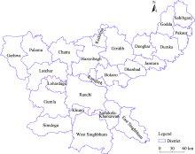
Fig. 1.
Overview of Jharkhand State."
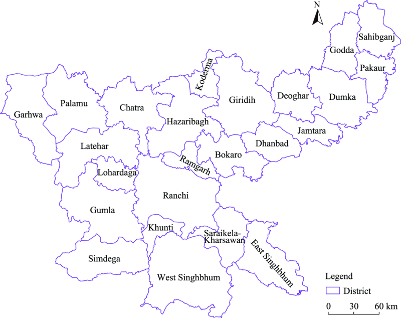
Table 1
Data sources of this study."
| Factor | Indicator | Data source | Year | Reference |
|---|---|---|---|---|
| Climatic factor | Precipitation | 1970-2000 | Fick and Hijmans ( | |
| Temperature | 1970-2000 | Fick and Hijmans ( | ||
| Topographical factor | Slope | ASTER DEM: | 2000 | |
| Elevation | ASTER DEM: | 2000 | ||
| Ecological factor | NDVI | Terra vegetation indices monthly 2021 MODIS: | 2003-2021 | Didan ( |
| Percent tree cover | 2000 | Hansen et al. ( | ||
| Socio-economic factor | Poverty rate | 2001 | Ahmad et al. ( | |
| Tribal dominance | 2001 | Ahmad et al. ( |

Fig. 2.
Flowchart for agroforestry suitability mapping."
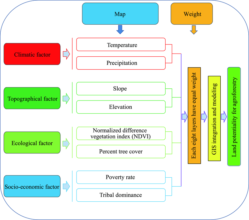
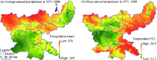
Fig. 3.
Spatial distribution of average annual precipitation (a) and mean annual temperature (b) in Jharkhand State in 1971-2000."

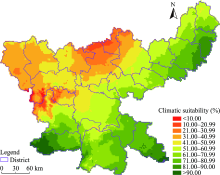
Fig. 4.
Climatic suitability of land for agroforestry in Jharkhand State."
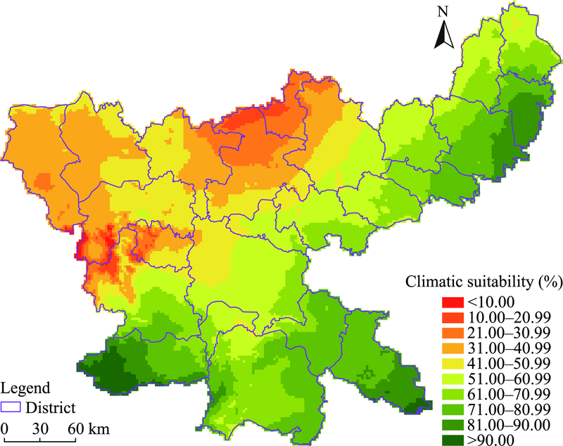
Table S1
District-wise climatic suitability of land for agroforestry in Jharkhand State."
| District | Climatic suitability of land for agroforestry (%) | |||
|---|---|---|---|---|
| Minimum | Maximum | Mean | Standard deviation | |
| Simdega | 63.99 | 100.00 | 82.32 | 9.13 |
| Pakur | 66.21 | 89.82 | 80.31 | 5.44 |
| East Singhbhum | 69.08 | 97.47 | 79.97 | 5.02 |
| Dumka | 53.87 | 89.70 | 73.05 | 7.92 |
| Saraikela-Kharsawan | 52.05 | 76.01 | 71.37 | 4.84 |
| Jamtara | 58.23 | 80.38 | 70.36 | 5.44 |
| West Singhbhum | 48.10 | 86.51 | 68.41 | 6.69 |
| Sahibganj | 46.63 | 76.61 | 61.65 | 6.33 |
| Godda | 48.79 | 72.63 | 59.78 | 5.22 |
| Deoghar | 49.59 | 70.72 | 59.49 | 4.90 |
| Dhanbad | 45.77 | 67.45 | 59.18 | 3.82 |
| Khunti | 48.97 | 72.95 | 57.46 | 5.10 |
| Bokaro | 37.13 | 72.31 | 57.19 | 6.40 |
| Ramgarh | 44.23 | 63.87 | 53.47 | 4.75 |
| Ranchi | 36.04 | 69.46 | 53.05 | 6.92 |
| Gumla | 4.94 | 81.23 | 51.75 | 15.97 |
| Giridih | 23.91 | 61.24 | 43.85 | 8.71 |
| Palamu | 30.22 | 47.56 | 39.04 | 3.60 |
| Latehar | 1.50 | 50.96 | 37.57 | 9.70 |
| Chatra | 21.04 | 46.67 | 37.23 | 5.95 |
| Lohardaga | 16.09 | 48.57 | 35.32 | 8.29 |
| Garhwa | 0.00 | 42.30 | 34.94 | 4.17 |
| Hazaribagh | 16.19 | 51.11 | 33.17 | 8.27 |
| Koderma | 17.39 | 34.69 | 24.80 | 4.08 |
Fig. 5.
Spatial distribution of elevation (a) and slope (b) in Jharkhand State."
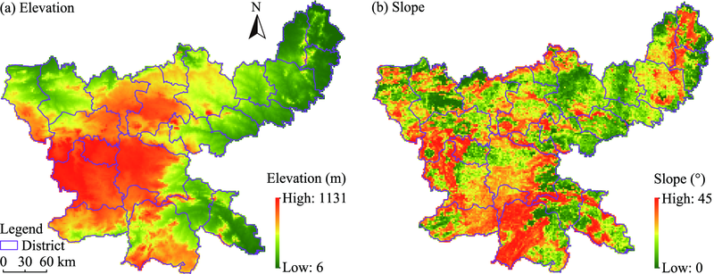
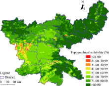
Fig. 6.
Topographical suitability of land for agroforestry in Jharkhand State."

Table S2
District-wise topographical suitability of land for agroforestry in Jharkhand State."
| District | Topographical suitability of land for agroforestry (%) | |||
|---|---|---|---|---|
| Minimum | Maximum | Mean | Standard deviation | |
| Pakur | 60.68 | 96.93 | 89.39 | 7.38 |
| Sahibganj | 56.71 | 100.00 | 87.85 | 8.64 |
| Jamtara | 78.11 | 94.01 | 87.27 | 2.09 |
| Godda | 59.67 | 95.34 | 86.92 | 7.10 |
| Dumka | 60.86 | 95.44 | 85.34 | 5.03 |
| Dhanbad | 39.11 | 94.73 | 84.51 | 6.31 |
| Deoghar | 48.47 | 88.60 | 84.19 | 3.76 |
| East Singhbhum | 42.09 | 94.50 | 83.19 | 10.46 |
| Palamu | 48.48 | 91.46 | 82.43 | 5.38 |
| Saraikela-Kharsawan | 34.44 | 92.38 | 80.75 | 11.94 |
| Bokaro | 27.36 | 89.68 | 80.26 | 8.97 |
| Giridih | 0.00 | 89.52 | 79.99 | 5.66 |
| Garhwa | 26.08 | 91.34 | 78.29 | 8.95 |
| Koderma | 39.02 | 92.21 | 77.87 | 6.00 |
| Chatra | 51.84 | 90.89 | 75.40 | 6.75 |
| Ramgarh | 32.54 | 84.81 | 74.67 | 7.77 |
| Simdega | 49.56 | 85.76 | 72.34 | 6.32 |
| Hazaribagh | 47.68 | 87.56 | 72.00 | 6.18 |
| West Singhbhum | 34.99 | 88.62 | 70.67 | 10.62 |
| Ranchi | 32.57 | 87.49 | 68.01 | 8.21 |
| Latehar | 22.42 | 84.69 | 67.47 | 12.82 |
| Khunti | 51.71 | 80.26 | 66.43 | 4.29 |
| Gumla | 28.37 | 73.38 | 59.84 | 10.01 |
| Lohardaga | 28.98 | 76.74 | 57.90 | 11.32 |
Fig.7.
Spatial distribution of NDVI (a) and percent tree cover (b) in Jharkhand State."
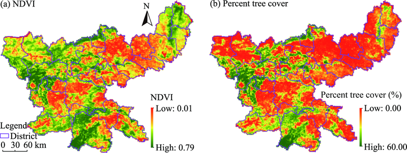
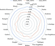
Fig. 8.
Seasonal (Kharif, Rabi and Zaid) NDVI value of each district in Jharkhand State."
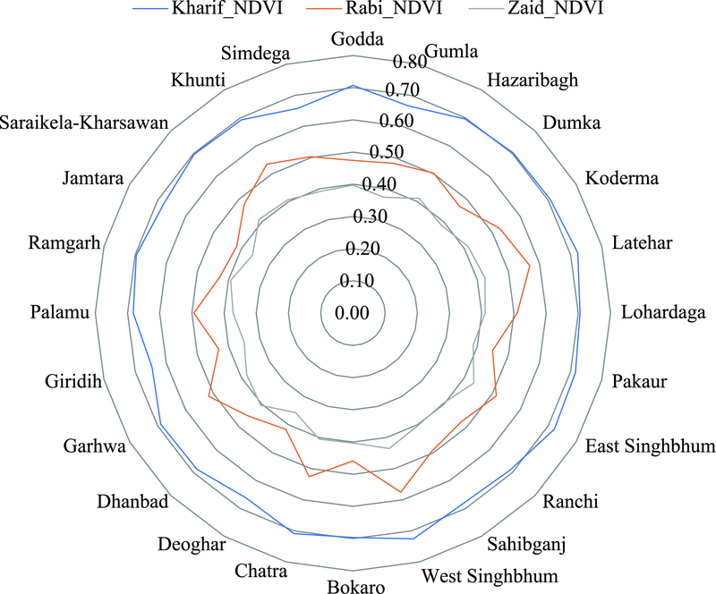
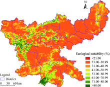
Fig. 9.
Ecological suitability of land for agroforestry in Jharkhand State."

Table S3
District-wise ecological suitability of land for agroforestry in Jharkhand State."
| District | Ecological suitability of land for agroforestry (%) | |||
|---|---|---|---|---|
| Minimum | Maximum | Mean | Standard deviation | |
| Latehar | 22.26 | 95.42 | 46.37 | 18.14 |
| West Singhbhum | 22.51 | 94.33 | 44.25 | 18.10 |
| Koderma | 22.22 | 76.17 | 39.90 | 16.28 |
| Lohardaga | 19.20 | 89.75 | 39.10 | 19.22 |
| Chatra | 23.03 | 84.41 | 38.12 | 12.24 |
| Hazaribagh | 0.00 | 84.76 | 36.24 | 13.55 |
| Garhwa | 10.51 | 80.22 | 35.92 | 12.72 |
| Khunti | 24.03 | 61.31 | 35.74 | 9.78 |
| Gumla | 21.66 | 89.75 | 35.18 | 14.45 |
| Simdega | 22.49 | 59.09 | 34.02 | 7.64 |
| Sahibganj | 1.97 | 63.47 | 33.91 | 8.21 |
| Palamu | 7.10 | 80.64 | 33.34 | 10.07 |
| Godda | 24.23 | 66.74 | 32.19 | 7.45 |
| East Singhbhum | 18.04 | 88.24 | 31.57 | 9.47 |
| Pakur | 16.97 | 55.23 | 30.93 | 5.95 |
| Ranchi | 6.34 | 75.30 | 30.58 | 8.64 |
| Saraikela-Kharsawan | 5.94 | 78.26 | 30.41 | 10.46 |
| Bokaro | 1.19 | 85.67 | 29.90 | 10.77 |
| Ramgarh | 19.11 | 71.26 | 29.04 | 7.23 |
| Dumka | 0.17 | 58.66 | 28.53 | 6.43 |
| Giridih | 21.03 | 100.00 | 27.90 | 8.42 |
| Dhanbad | 1.33 | 61.87 | 27.63 | 5.29 |
| Jamtara | 0.29 | 33.72 | 25.41 | 2.71 |
| Deoghar | 20.75 | 44.66 | 24.91 | 1.92 |
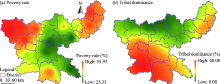
Fig. 10.
Spatial distribution of the poverty rate (a) and tribal dominance (b) in Jharkhand State."
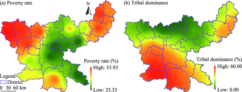
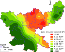
Fig. 11.
Socio-economic suitability of land for agroforestry in Jharkhand State."

Table S4
District-wise socio-economic suitability of land for agroforestry in Jharkhand State."
| District | Socio-economic suitability of land for agroforestry (%) | |||
|---|---|---|---|---|
| Minimum | Maximum | Mean | Standard deviation | |
| Simdega | 29.98 | 97.46 | 91.77 | 7.03 |
| Gumla | 37.38 | 96.07 | 86.83 | 4.28 |
| West Singhbhum | 22.48 | 100.00 | 85.52 | 10.39 |
| Lohardaga | 68.40 | 92.11 | 81.04 | 4.45 |
| Khunti | 64.73 | 92.49 | 79.18 | 5.88 |
| Latehar | 45.57 | 92.80 | 76.49 | 9.10 |
| Pakur | 31.79 | 82.30 | 76.39 | 4.71 |
| Dumka | 34.65 | 85.81 | 73.88 | 8.41 |
| Garhwa | 49.45 | 81.30 | 73.78 | 4.82 |
| Godda | 51.95 | 77.49 | 70.41 | 4.38 |
| Sahibganj | 38.16 | 74.72 | 68.34 | 4.05 |
| Palamu | 49.74 | 77.59 | 64.46 | 5.47 |
| Jamtara | 24.49 | 71.66 | 54.35 | 11.86 |
| Ranchi | 11.01 | 86.14 | 54.15 | 13.07 |
| Saraikela-Kharsawan | 23.47 | 73.46 | 53.97 | 7.64 |
| Chatra | 24.69 | 64.61 | 46.55 | 8.18 |
| Deoghar | 30.85 | 68.79 | 43.45 | 7.93 |
| East Singhbhum | 0.01 | 58.19 | 39.39 | 7.02 |
| Giridih | 19.24 | 41.47 | 29.97 | 5.03 |
| Ramgarh | 20.77 | 45.10 | 28.54 | 5.67 |
| Hazaribagh | 19.20 | 53.69 | 28.31 | 7.53 |
| Dhanbad | 10.95 | 47.50 | 23.56 | 8.76 |
| Bokaro | 10.39 | 29.64 | 23.19 | 2.53 |
| Koderma | 16.37 | 27.32 | 19.55 | 1.97 |
Fig. 12.
Land potentiality for agroforestry in Jharkhand State."

Table 2
District-wise statistics of land potentiality for agroforestry in Jharkhand State."
| District | Poverty rate (%) | Area (km2) | Land potentiality for agroforestry (%) | |||
|---|---|---|---|---|---|---|
| Minimum | Maximum | Mean | Standard deviation | |||
| Godda | 48.56 | 2232.38 | 46.53 | 79.55 | 63.43 | 4.16 |
| Gumla | 36.41 | 5220.18 | 8.48 | 81.06 | 55.88 | 9.31 |
| Hazaribagh | 32.65 | 4783.22 | 12.93 | 51.38 | 25.52 | 7.60 |
| Dumka | 46.52 | 3754.17 | 40.06 | 84.62 | 68.84 | 8.35 |
| Koderma | 32.91 | 1314.38 | 12.02 | 37.99 | 22.10 | 5.84 |
| Latehar | 47.99 | 4358.95 | 2.83 | 78.59 | 53.12 | 10.15 |
| Lohardaga | 39.00 | 1491.91 | 26.93 | 66.43 | 46.35 | 5.80 |
| Pakur | 44.01 | 1805.13 | 55.11 | 81.76 | 76.52 | 4.07 |
| East Singhbhum | 26.60 | 3560.22 | 32.47 | 68.67 | 56.18 | 3.53 |
| Ranchi | 27.62 | 6551.50 | 24.74 | 64.37 | 42.70 | 7.73 |
| Sahibganj | 42.69 | 2190.06 | 41.07 | 76.42 | 64.63 | 5.02 |
| West Singhbhum | 43.63 | 7263.84 | 42.57 | 100.00 | 72.70 | 8.34 |
| Bokaro | 29.47 | 2852.60 | 19.05 | 45.95 | 35.48 | 3.99 |
| Chatra | 46.20 | 3742.72 | 16.28 | 62.82 | 38.76 | 9.05 |
| Deoghar | 36.78 | 2427.34 | 32.68 | 65.51 | 45.69 | 6.17 |
| Dhanbad | 26.76 | 2074.03 | 28.06 | 55.29 | 37.50 | 6.06 |
| Garhwa | 53.93 | 4070.38 | 16.73 | 69.52 | 50.83 | 4.70 |
| Giridih | 39.96 | 4976.93 | 19.31 | 46.99 | 31.25 | 4.81 |
| Palamu | 49.24 | 4337.29 | 37.20 | 68.69 | 49.05 | 4.31 |
| Ramgarh | 25.33 | 1352.23 | 24.33 | 45.11 | 33.14 | 3.59 |
| Jamtara | 41.26 | 1797.41 | 36.35 | 72.26 | 57.70 | 9.13 |
| Saraikela-Kharsawan | 33.60 | 2579.22 | 38.84 | 66.98 | 57.28 | 4.44 |
| Khunti | 35.75 | 1071.87 | 47.73 | 77.74 | 58.40 | 6.38 |
| Simdega | 38.26 | 3908.04 | 48.55 | 94.21 | 78.20 | 5.73 |
Table 3
Land potentiality for agroforestry in Jharkhand State."
| Agroforestry suitability | Area (km2) | Proportion of total area (%) |
|---|---|---|
| Low (<30.00%) | 7932.17 | 9.95 |
| Medium (30.00%-49.99%) | 29,783.92 | 37.36 |
| High (50.00%-69.99%) | 30,147.60 | 37.82 |
| Very high (≥70.00%) | 11,852.31 | 14.87 |
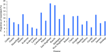
Fig. 13.
Proportion of wasteland to total land of each district in Jharkhand State. Note that the proportion values of wasteland of the newly created Ramgarh and Kunti districts were merged into the Hazaribagh and Ranchi districts, respectively, as these two new districts were parts of Hazaribagh and Ranchi districts before 2008."

| [1] | Ahmad, F., Uddin, M.M., Goparaju, L., 2018. An evaluation of vegetation health and the socioeconomic dimension of the vulnerability of Jharkhand state of India in climate change scenarios and their likely impact: a geospatial approach. Environ. Socio-Econ. S. 6(4), 39-47. |
| [2] |
Ahmad, F., Uddin, M.M., Goparaju, L., 2019. Agroforestry suitability mapping of India: geospatial approach based on FAO guidelines. Agroforest. Syst. 93(4), 1319-1336.
doi: 10.1007/s10457-018-0233-7 |
| [3] |
Ahmad, F., Uddin, M.M., Goparaju, L., et al., 2020. Quantification of the land potential for scaling agroforestry in South Asia. KN-Journal of Cartography and Geographic Information. 70, 71-89.
doi: 10.1007/s42489-020-00045-0 |
| [4] |
Ahmad, F., Uddin, M.M., Goparaju, L., et al., 2021. Tree suitability modeling and mapping in Nepal: a geospatial approach to scaling agroforestry. Model. Earth Syst. Env. 7(1), 169-179.
doi: 10.1007/s40808-020-00922-7 |
| [5] |
Asbjornsen, H., Hernandez-Santana, V., Liebman, M., et al., 2014. Targeting perennial vegetation in agricultural landscapes for enhancing ecosystem services. Renew. Agr. Food Syst. 29 (2), 101-125.
doi: 10.1017/S1742170512000385 |
| [6] |
Baja, S., Chapman, D.M., Dragovich, D., 2002. A conceptual model for defining and assessing land management units using a fuzzy modeling approach in GIS environment. Environ. Manage. 29(5), 647-661.
pmid: 12180179 |
| [7] | Baraik, V.K., 2019. Dimensions of tribal education and employment in Jharkhand: linkage of educational level and industrial category. Jharkhand Journal of Development and Management Studies. 17(3), 8159-8174. |
| [8] | Bathgate, S., 2011. Ecological Site Classification. [2022-03-12]. https://cdn.forestresearch.gov.uk/2022/02/esc_manual.pdf. |
| [9] |
Brown, M.E., Funk, C.C., 2008. Food security under climate change. Science. 319(5863), 580-581.
doi: 10.1126/science.1154102 |
| [10] |
Carlson, K.M., Gerber, J.S., Mueller, N.D., et al., 2017. Greenhouse gas emissions intensity of global croplands. Nat. Clim. Change. 7, 63-68.
doi: 10.1038/NCLIMATE3158 |
| [11] | Census of India, 2022. Jharkhand Population 2011-2022. [2022-04-28]. https://www.census2011.co.in/census/state/jharkhand.html. |
| [12] |
Chandniha, S.K., Meshram, S.G., Adamowski, J.F., et al., 2017. Trend analysis of precipitation in Jharkhand State, India. Theor. Appl. Climatol. 130(1-2), 261-274.
doi: 10.1007/s00704-016-1875-x |
| [13] |
Chen, X.P.S., 2016. An analysis of climate impact on landscape design. Atmospheric and Climate Sciences. 6, 475-481.
doi: 10.4236/acs.2016.63037 |
| [14] | Climate data, 2022. [2022-04-10]. https://en.climate-data.org/asia/india/jharkhand-772/. |
| [15] |
Dağıstanlı, C., Turan, İ.D., Dengiz, O., 2018. Evaluation of the suitability of sites for outdoor recreation using a multi-criteria assessment model. Arab. J. Geosci. 11(17), 492, doi: 10.1007/s12517-018-3856-0.
doi: 10.1007/s12517-018-3856-0 |
| [16] | Didan, K., 2021. MOD13A3 v061 MODIS/Terra Vegetation Indices Monthly L3 Global 1km SIN Grid. [2022-02-08]. https://doi.org/10.5067/MODIS/MOD13A3.061. |
| [17] |
Dollinger, J., Jose, S., 2018. Agroforestry for soil health. Agroforest. Syst. 92(2), 213-219.
doi: 10.1007/s10457-018-0223-9 |
| [18] |
Everest, T., 2021. Suitable site selection for pistachio (Pistacia vera) by using GIS and multi-criteria decision analyses (a case study in Turkey). Environ. Dev. Sustain. 23, 7686-7705.
doi: 10.1007/s10668-020-00941-5 |
| [19] |
Everest, T., Sungur, A., Ozcan, H., 2021. Determination of agricultural land suitability with a multiple-criteria decision-making method in Northwestern Turkey. Int. J. Environ. Sci. Te. 18(5), 1073-1088.
doi: 10.1007/s13762-020-02869-9 |
| [20] | Evugin, S., 2021. Poverty Least in Kerala; Highest In UP, Bihar, Jharkhand. [2020-08-18]. https://www.deshabhimani.com/english/news/national/least-poverty-in-kerala-highest-in-up-bihar-jharkhand/5414. |
| [21] | FAO (Food and Agriculture Organization of the United Nations), 1976. A Framework for Land Evaluation. Rome: FAO, 20. |
| [22] | FAO, 2007. Land evaluation. Towards a revised framework. [2022-03-14]. https://www.fao.org/fileadmin/templates/nr/images/resources/pdf_documents/lman_070601_en.pdf. |
| [23] | FAO, 2018. Agroforestry. [2022-04-16]. https://www.fao.org/sustainable-forest-management/toolbox/modules/agroforestry/basic-knowledge/en/?type=111. |
| [24] | FAO, IFAD (International Fund for Agricultural Development), WFP (World Food Programme), 2015. The state of food insecurity in the world 2015.Meeting the 2015 international hunger targets:taking stock of uneven progress. [2022-03-16]. http://www.fao.org/3/i4646e/i4646e.pdf. |
| [25] | FD Report, 2012. Wastelands of Jharkhand. [2022-05-16]. http://forest.jharkhand.gov.in/About_us/pdf/wastelands.pdf. |
| [26] |
Fick, S.E., Hijmans, R.J., 2017. WorldClim 2: new 1-km spatial resolution climate surfaces for global land areas. Int J. Climatol. 37, 4302-4315.
doi: 10.1002/joc.5086 |
| [27] |
Gerassis, S., Albuquerque, M.T.D., Roque, N., et al., 2021. Future habitat suitability for species under climate change-lessons learned from the strawberry tree case study. Forest. Ecol. Manag. 491, 119150, doi: 10.1016/j.foreco.2021.119150.
doi: 10.1016/j.foreco.2021.119150 |
| [28] | GHG Greenhouse Gas Platform India, 2014. Trend analysis of GHG emissions in Jharkhand. [2022-05-16]. http://www.ghgplatform-india.org/Images/Publications/GHGPI-PhaseIII-Trend%20Analysis%20State-Jharkhand-Dec'19.pdf. |
| [29] | GoJ, 2022. Minerals in Jharkhand. [2022-05-16]. https://www.jharkhand.gov.in/home/AboutMinerals. |
| [30] | Goparaju, L., Ahmad, F., Uddin, M., et al., 2020. Agroforestry: An effective multi-dimensional mechanism for achieving sustainable development goals. Ecol. Quest. 31(3), 63-71. |
| [31] | Han, J.W., Kamber, M., Pei, J., 2012. Data Mining:Concepts and Technique, (3rdedition). Amsterdam: Elsevier Inc., 279-323. |
| [32] |
Hansen, M.C., Potapov, P.V., Moore, R., et al., 2013. High-resolution global maps of 21st-century forest cover change. Science. 342(6160), 850-853.
doi: 10.1126/science.1244693 pmid: 24233722 |
| [33] |
Hernandez, R.R., Debenport, S.J., Leewis, M.-C.C.E., et al., 2015. The native shrub, Piliostigma reticulatum, as an ecological “resource island” for mango trees in the Sahel. Agr. Ecosyst. Environ. 204, 51-61.
doi: 10.1016/j.agee.2015.02.009 |
| [34] |
Herzberg, R., Pham, T.G., Kappas, M., et al., 2019. Multi-Criteria decision analysis for the land evaluation of potential agricultural land use types in a hilly area of Central Vietnam. Land-Basel. 8(6), 90, doi: 10.3390/land8060090.
doi: 10.3390/land8060090 |
| [35] | ICRAF (International Council for Research in Agroforestry), 2010. Agroforestry Policy Initiative. [2022-03-06]. http://old.worldagroforestry.org/downloads/publications/PDFs/RP09004.DOC. |
| [36] | India Today, 2011. Not poor if you earn Rs 32 a day: Planning Commission https://www.indiatoday.in/india/north/story/planning-commission-bpl-earn-rs-25-a-day-india-141619-2011-09-21. |
| [37] | IISD (International Institute for Sustainable Development), 2018. Report Shows Agroforestry’s Contribution to Several SDGs. [2022-07-13]. https://sdg.iisd.org/news/report-shows-agroforestrys-contribution-to-several-sdgs/. |
| [38] |
Jose, S., 2009. Agroforestry for ecosystem services and environmental benefits: an overview. Agroforest. Syst. 76(1), 1-10.
doi: 10.1007/s10457-009-9229-7 |
| [39] | Khan, M.A., 2022. Ownership Scheme: Why tribals are opposing drone surveys in Jharkhand. [2022-03-08]. https://www.downtoearth.org.in/news/governance/ownership-scheme-why-tribals-are-opposing-drone-surveys-in-jharkhand-81562. |
| [40] |
Kho, R.M., 2000. A general tree-environment-crop interaction equation for predictive understanding of agroforestry systems. Agr. Ecosyst. Environ. 80(1-2), 87-100.
doi: 10.1016/S0167-8809(00)00136-5 |
| [41] | Kumar, A., Chandra, G., 2017. Insect pest infestation on Gmelina arborea Roxb. in different agroclimatic zones of Jharkhand, India. Arthropods. 6(1), 8-20 |
| [42] |
Lang, A.C., von Oheimb, G., Scherer-Lorenzen, M., et al., 2014. Mixed afforestation of young subtropical trees promotes nitrogen acquisition and retention. J. Appl. Ecol. 51(1), 224-233.
doi: 10.1111/1365-2664.12157 |
| [43] | Leakey, R.R.B., 1996. Definition of agroforestry revisited. Agroforestry Today. 8(1), 5-7. |
| [44] | Mahato, S., Dasgupta, S., Todaria, N.P., et al., 2016. Agroforestry mapping and characterization in four districts of Garhwal Himalaya. Energy. Ecol. Environ. 1(2), 86-97. |
| [45] | Maji, A.K., Reddy, G.P.O., Sarkar, D., 2010. Degraded and Wastelands of India, Status and Spatial Distribution. New Delhi: ICAR (Indian Council of Agricultural Research), 14. |
| [46] |
Malezieux, E., Crozat, Y., Dupraz, C., et al., 2009. Mixing plant species in cropping systems: concepts, tools and models. A review. Agron. Sustain. Dev. 29(1), 43-62.
doi: 10.1051/agro:2007057 |
| [47] |
Mandal, V.P., Rehman, S., Ahmed, R., et al., 2020. Land suitability assessment for optimal cropping sequences in Katihar district of Bihar, India using GIS and AHP. Spat. Inf. Res. 28(5), 589-599.
doi: 10.1007/s41324-020-00315-z |
| [48] | Meneses-Tovar, C.L., 2011. NDVI as indicator of degradation. [2022-02-16]. https://www.fao.org/3/i2560e/i2560e07.pdf. |
| [49] |
Mertz, O., Halsnaes, K., Olesen, J.E., et al., 2009. Adaptation to climate change in developing countries. Environ. Manage. 43(5), 743-752.
doi: 10.1007/s00267-008-9259-3 pmid: 19184576 |
| [50] | Montagnini, F., 2020. The contribution of agroforestry to restoration and conservation:biodiversity islands in degraded landscapes. n: Dagar. J.C., Gupta, S.R., Teketay, D., (eds). Agroforestry for Degraded Landscapes. Springer: Singapore, 445-479. |
| [51] | Morton, J.F., 2007. The impact of climate change on smallholder and subsistence agriculture. P. Natl. Acad. Sci. USA. 104(50), 19680-19685. |
| [52] |
Musakwa, W., 2018. Identifying land suitable for agricultural land reform using GIS-MCDA in South Africa. Environ. Dev. Sustain. 20(5), 2281-2299.
doi: 10.1007/s10668-017-9989-6 |
| [53] | Nair, P.K.R., 1984. Soil Productivity Aspect of Agroforestry. Nairobi: ICRAF, 85. |
| [54] |
Nair, P.K.R., 2011. Agroforestry systems and environmental quality: introduction. J. Environ. Qual. 40(3), 784-790.
doi: 10.2134/jeq2011.0076 pmid: 21546663 |
| [55] | Nair, P.K.R., Toth, G.G., 2016. Measuring agricultural sustainability in agroforestry systems. In: Lal, R., Kraybill, D., Hansen, D.O., (eds). Climate Change and Multi-Dimensional Sustainability in African Agriculture. Springer: Cham, 365-394. |
| [56] |
Nath, A.J., Kumar, R., Devi, N.B., et al., 2021. Agroforestry land suitability analysis in the Eastern Indian Himalayan region. Environmental Challenges. 4, 100199, doi: 10.1016/j.envc.2021.100199.
doi: 10.1016/j.envc.2021.100199 |
| [57] | NITI Aayog, 2021. National Multidimensional Poverty Index. Baseline Report Based on NFHS-4 (National Family Health Survey-4)(2015-16). [2022-04-10]. https://www.niti.gov.in/sites/default/files/2021-11/National_MPI_India-11242021.pdf. |
| [58] |
Oliver, M.A., Gregory, P.J., 2015. Soil, food security and human health: a review. Eur. J. Soil Sci. 66(2), 257-276.
doi: 10.1111/ejss.12216 |
| [59] | Opanda, S., 2022. How Many Trees Needed to Offset Your Carbon Emissions? [2022-05-16]. https://8billiontrees.com/carbon-offsets-credits/reduce-co2-emissions/how-many-trees-offset-carbon-emissions/. |
| [60] | Oraon, P.R., Singh, B.K., Kumar, A., et al., 2018. Traditional agroforestry practices of Jharkhand: a viable options for livelihood upliftment. Multiloginic in Science. 8(special C), 66-67. |
| [61] |
Pardon, P., Reubens, B., Mertens, J., et al., 2018. Effects of temperate agroforestry on yield and quality of different arable intercrops. Agr. Syst. 166, 135-151.
doi: 10.1016/j.agsy.2018.08.008 |
| [62] |
Perles-Garcia, M.D., Kunz, M., Fichtner, A., et al., 2021. Tree species richness promotes an early increase of stand structural complexity in young subtropical plantations. J. Appl. Ecol. 58(10), 2305-2314.
doi: 10.1111/1365-2664.13973 |
| [63] |
Ramos, N.C., Gastauer, M., Cordeiro, A.D.C., 2015. Environmental filtering of agroforestry systems reduces the risk of biological invasion. Agroforest. Syst. 89(2), 279-289.
doi: 10.1007/s10457-014-9765-7 |
| [64] | Rao, U., 2022. Andhra Pradesh farmers reap carbon credits from agriculture. [2022-05-16]. https://article.wn.com/view/2022/03/24/Andhra_Pradesh_farmers_reap_carbon_credits_from_agriculture/. |
| [65] | Rosenstock, T.S., Lamanna, C., Chesterman, S., et al., 2016. The scientific basis of climate-smart agriculture:A systematic review protocol. In: CCAFS (Climate Change, Agriculture and Food Security) Working Paper No. 136. CGIAR. Copenhagen, Denmark. |
| [66] | Roy, P.S., Meiyappan, P.K., Joshi, M.P., et al., 2016. Decadal land use and land cover classifications across India, 1985, 1995, 2005. [2022-03-12]. https://daac.ornl.gov/VEGETATION/guides/Decadal_LULC_India.html. |
| [67] | Sandeep, D., Sharan, A., 2017. In Jharkhand, using an old technique for sustainable water. [2022-05-15]. https://news.climate.columbia.edu/2017/05/24/in-jharkhand-using-an-old-technique-for-sustainable-water/. |
| [68] |
Scholten, T., Goebes, P., Kuhn, P., et al., 2017. On the combined effect of soil fertility and topography on tree growth in subtropical forest ecosystems-a study from SE China. J. Plant. Ecol. 10(1), 111-127.
doi: 10.1093/jpe/rtw065 |
| [69] | Seeberg-Elverfeldt, C., 2010. Carbon Finance Possibilities for Agriculture, Forestry and Other Land Use Projects in a Smallholder Context. Rome: FAO, 1-24. |
| [70] |
Smith, J., Pearce, B.D., Wolfe, M.S., 2013. Reconciling productivity with protection of the environment: Is temperate agroforestry the answer? Renew Agr. Food Syst. 28(1), 80-92.
doi: 10.1017/S1742170511000585 |
| [71] | Talukdar, N.R., Choudhury, P., Ahmad, F., et al., 2020. Habitat suitability of the Asiatic elephant in the trans-boundary Patharia Hills Reserve Forest, northeast India. Model. Earth Syst. Environ. 6, 1951-1961. |
| [72] | Tewari, V.P., Dagar, J.C., 2017. Introduction. In: Dagar, J.C., Tewari, V.P., (eds). Agroforestry. Singapore: Springer, 1-11. |
| [73] | Tirkey, A.S., Ghosh, M., Pandey, A.C., et al., 2018. Assessment of climate extremes and its long term spatial variability over the Jharkhand State of India. Egypt. J. Remote. Sens. 21(1), 49-63. |
| [74] | Verheye, W., Koohafkan, P., Nachtergaele, F., 1982. Land Use, Land Cover and Soil Sciences-Vol. II-The FAO Guidelines for Land Evaluation. Paris: UNESCO-EOLSS (United Nations Educational, Scientific, and Cultural Organization-Encyclopedia of Life Support Systems), 1-23. |
| [75] | Wadood, A., Kumari, P., 2009. Impact of climate change on Jharkhand agriculture:mitigation and adoption. In: ISPRS ArchivesXXXVIII-8/W 3 Workshop Proceedings:Impact of Climate Change on Agriculture. Hanover: ISPRS (International Society for Photogrammetry and Remote Sensing),207-210. |
| [76] | Walpole, M., Smith, J., Rosser, A., et al., 2013. Smallholders, Food Security, and the Environment. Rome: IFAD, UNEP (United Nations Environment Programme), 6-22. |
| [77] | WFP, 2011. A food security and vulnerability atlas of Indonesia. [2022-03-06]. https://reliefweb.int/report/indonesia/food-security-and-vulnerability-atlas-indonesia-2009. |
| [78] |
Wheeler, T., von Braun, J., 2013. Climate change impacts on global food security. Science. 341(6145), 508-513.
doi: 10.1126/science.1239402 pmid: 23908229 |
| [79] | Wojtkowski, P.A., 1998. The Theory and Practice of Agroforestry Design. A Comprehensive Study of The Theories, Concepts and Conventions That Underlie The Successful Use of Agroforestry. Enfield: Science Publishers, 282. |
| [80] | WorldData, 2022. The Climate in India. Average Daytime and Nighttime Temperatures. [2022-04-10]. https://www.worlddata.info/asia/india/climate-jharkhand.php. |
| [81] |
Yohannes, H., Soromessa, T., 2018. Land suitability assessment for major crops by using GIS-based multi-criteria approach in AnditTid watershed, Ethiopia. Cogent. Food Agr. 4(1), doi: 10.1080/23311932.2018.1470481.
doi: 10.1080/23311932.2018.1470481 |
| [82] |
Zhang, C.S., Li, X.Y., Chen, L., et al., 2016. Effects of topographical and edaphic factors on tree community structure and diversity of subtropical mountain forests in the Lower Lancang River Basin. Forests. 7(10), 222, doi: 10.3390/f7100222.
doi: 10.3390/f7100222 |
| [83] |
Zolekar, R.B., Bhagat, V.S., 2015. Multi-criteria land suitability analysis for agriculture in hilly zone: Remote sensing and GIS approach. Comput. Electron. Agr. 118, 300-321.
doi: 10.1016/j.compag.2015.09.016 |
| [84] | Zomer, R.J., Bossio, D.A., Trabucco, A., et al., 2007. Trees and water: smallholder agroforestry on irrigated lands in Northern India. International Water Management Institute. Colombo, Sri Lanka. |
| [1] | Issa NYASHILU, Robert KIUNSI, Alphonce KYESSI. Climate change vulnerability assessment in the new urban planning process in Tanzania [J]. Regional Sustainability, 2024, 5(3): 100155-. |
| [2] | Homayoon RAOUFI, Hamidreza JAFARI, Wakil Ahmad SARHADI, Esmail SALEHI. Assessing the impact of climate change on agricultural production in central Afghanistan [J]. Regional Sustainability, 2024, 5(3): 100156-. |
| [3] | Frank BAFFOUR-ATA, Louisa BOAKYE, Moses Tilatob GADO, Ellen BOAKYE-YIADOM, Sylvia Cecilia MENSAH, Senyo Michael KWAKU KUMFO, Kofi Prempeh OSEI OWUSU, Emmanuel CARR, Emmanuel DZIKUNU, Patrick DAVIES. Climatic and non-climatic factors driving the livelihood vulnerability of smallholder farmers in Ahafo Ano North District, Ghana [J]. Regional Sustainability, 2024, 5(3): 100157-. |
| [4] | SONG Boyi, ZHANG Shihang, LU Yongxing, GUO Hao, GUO Xing, WANG Mingming, ZHANG Yuanming, ZHOU Xiaobing, ZHUANG Weiwei. Characteristics and drivers of the soil multifunctionality under different land use and land cover types in the drylands of China [J]. Regional Sustainability, 2024, 5(3): 100162-. |
| [5] | Camillus Abawiera WONGNAA, Alex Amoah SEYRAM, Suresh BABU. A systematic review of climate change impacts, adaptation strategies, and policy development in West Africa [J]. Regional Sustainability, 2024, 5(2): 100137-. |
| [6] | Suchitra PANDEY, Geetilaxmi MOHAPATRA, Rahul ARORA. Spatio-temporal variation of depth to groundwater level and its driving factors in arid and semi-arid regions of India [J]. Regional Sustainability, 2024, 5(2): 100143-. |
| [7] | Shibu DAS, Kaushal Kumar SHARMA, Suranjan MAJUMDER, Debabrata DAS, Indrajit Roy CHOWDHURY. Spatio-temporal variation and relationship between agricultural efficiency and irrigation intensity in a semi-arid region of India [J]. Regional Sustainability, 2024, 5(2): 100144-. |
| [8] | WANG Tao, ZHOU Daojing, FAN Jie. Spatial differences of Sustainable Development Goals (SDGs) among counties (cities) on the northern slope of the Kunlun Mountains [J]. Regional Sustainability, 2024, 5(1): 100108-. |
| [9] | Ramya Kundayi RAVI, Priya BABY, Nidhin ELIAS, Jisa George THOMAS, Kathyayani Bidadi VEERABHADRAIAH, Bharat PAREEK. Preparedness, knowledge, and perception of nursing students about climate change and its impact on human health in India [J]. Regional Sustainability, 2024, 5(1): 100116-. |
| [10] | Ashma SUBEDI, Nani RAUT, Smriti GURUNG. How Himalayan communities are changing cultivation practices in the context of climate change [J]. Regional Sustainability, 2023, 4(4): 378-389. |
| [11] | LIU Binsheng, ZHANG Xiaohui, TIAN Junfeng, CAO Ruimin, SUN Xinzhang, XUE Bin. Rural sustainable development: A case study of the Zaozhuang Innovation Demonstration Zone in China [J]. Regional Sustainability, 2023, 4(4): 390-404. |
| [12] | Liton Chandra VOUMIK, Md. Hasanur RAHMAN, Md. Maznur RAHMAN, Mohammad RIDWAN, Salma AKTER, Asif RAIHAN. Toward a sustainable future: Examining the interconnectedness among Foreign Direct Investment (FDI), urbanization, trade openness, economic growth, and energy usage in Australia [J]. Regional Sustainability, 2023, 4(4): 405-415. |
| [13] | Rula AWAD, Hosam TITI, Aziza MOHAMED-BRAHMI, Mohamed JAOUAD, Aziza GASMI-BOUBAKER. Small ruminant value chain in Al-Ruwaished District, Jordan [J]. Regional Sustainability, 2023, 4(4): 416-424. |
| [14] | WU Fan, LIANG Youjia, LIU Lijun, YIN Zhangcai, HUANG Jiejun. Identifying eco-functional zones on the Chinese Loess Plateau using ecosystem service bundles [J]. Regional Sustainability, 2023, 4(4): 425-440. |
| [15] | Surendra Singh JATAV, Kalu NAIK. Measuring the agricultural sustainability of India: An application of Pressure-State-Response (PSR) model [J]. Regional Sustainability, 2023, 4(3): 218-234. |
| Viewed | ||||||
|
Full text |
|
|||||
|
Abstract |
|
|||||
 REGSUS Wechat
 新公网安备 65010402001202号