Regional Sustainability ›› 2025, Vol. 6 ›› Issue (2): 100211.doi: 10.1016/j.regsus.2025.100211cstr: 32279.14.REGSUS.20250010
• Research article • Previous Articles Next Articles
Rizal IMANAa, Andrea Emma PRAVITASARIb,c,*( ), Didit Okta PRIBADIc,d
Received:2024-06-19
Revised:2025-04-04
Accepted:2025-05-06
Published:2025-04-30
Online:2025-05-21
Contact:
*E-mail address: andreaemma@apps.ipb.ac.id (Andrea Emma PRAVITASARI).
Rizal IMANA, Andrea Emma PRAVITASARI, Didit Okta PRIBADI. Analysis of environmental protection priority zones and their impacts on urban planning in small- and medium-sized cities of Indonesia[J]. Regional Sustainability, 2025, 6(2): 100211.
Table 1
Data types and sources."
| Data type | Source |
|---|---|
| Map of protected rice fields | Regulation number 1589/SK-HK.02.01/XII/2021 issued by Ministry of Agrarian Affairs and Spatial Planning Republic of Indonesia ( |
| Map of green open spaces | Regulation number 1 of 2021 issued by Tegal City Government ( |
| Map of forest areas | Regulation number 6605/MENLHK-PKTL/KUH/PLA.2/11/2019 issued by Ministry of Environment and Forestry Republic of Indonesia ( |
| Map of river and lake boundaries | Indonesian Geospatial Information Agency ( |
| Map of shoreline | Indonesian Geospatial Information Agency ( |
| Map of disaster-prone areas | Indonesia’s National Board for Disaster Management ( |
| Slope map | Earth Resources Observation and Science (EROS) Center ( |
Fig. 1.
Methodological flowchart used in this study. PCA, principal component analysis; RSEI, remote sensing ecological index; UGB, urban growth boundary."
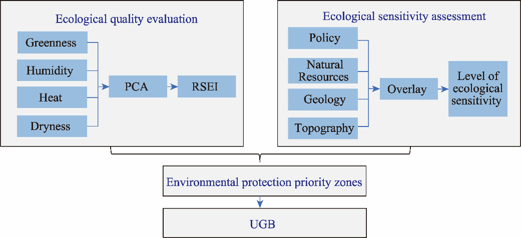
Table 2
Indicators, variables, and weights used for assessing ecological sensitivity."
| Indicator | Variable | Ecological sensitivity level | Data source | ||||
|---|---|---|---|---|---|---|---|
| Non- ecological sensitivity | Light ecological sensitivity | Moderate ecological sensitivity | High ecological sensitivity | Very high ecological sensitivity | |||
| Policy | Area of protected rice fields | Rice fields (5) | Regulation number 1589/SK-HK.02.01/XII/2021 issued by Ministry of Agrarian Affairs and Spatial Planning Republic of Indonesia ( | ||||
| Area of green open spaces | Green open spaces (5) | Regulation number 1 of 2021 issued by Tegal City Government ( | |||||
| Natural resources | Forest areas | Permanent production forest and limited production forest (4) | Nature reserves and protected forests (5) | Regulation number 6605/MEN LHK-PKTL/KUH/PLA.2/11/ 2019 issued by Ministry of Environment and Forestry Republic of Indonesia ( | |||
| Riverbanks | Within a distance of 0-50 m (5) | Regulation number 28/PRT/M/ 2015 issued by Ministry of Public Works and Housing Republic of Indonesia ( | |||||
| Lake borders | Within a distance of 0-100 m (5) | Regulation number 28/PRT/M/ 2015 issued by Ministry of Public Works and Housing Republic of Indonesia ( | |||||
| Coastal line | Within a distance of 0-100 m (5) | Regulation number 51 of 2016 issued by Presidential Regulation of the Republic of Indonesia ( | |||||
| Geology | Flood hazard | Low with a score of 0.0-0.3 (2) | Moderate with a score of 0.3-0.6 (3) | High with a score of 0.6-1.0 (4) | Indonesia’s National Board for Disaster Management ( | ||
| Volcanic eruption hazard | Low with a score of 0.0-0.3 (2) | Moderate with a score of 0.3-0.6 (3) | High with a score of 0.6-1.0 (4) | Indonesia’s National Board for Disaster Management ( | |||
| Landslide and soil movement hazard | Low with a score of 0.0-0.3 (2) | Moderate with a score of 0.3-0.6 (3) | High with a score of 0.6-1.0 (4) | Indonesia’s National Board for Disaster Management ( | |||
| Topography | Slope | 0.00%- 8.00% (1) | 8.00%- 15.00% (2) | 25.00%- 30.00% (3) | 30.00%- 45.00% (4) | >45.00% (5) | Rahmad et al. ( |
Table 3
Determination of environmental protection priority zones."
| Classification | First priority zone (ecological constraint zone) | Second priority zone (conditional urban development zone) | Third priority zone (urban development zone) |
|---|---|---|---|
| Ecological evaluation based on remote sensing ecological index (RSEI) results | Very good ecological quality | Good ecological quality | Average ecological quality, poor ecological quality, and very poor ecological quality |
| Ecological sensitivity assessment results | Very high ecological sensitivity | High ecological sensitivity | Moderate ecological sensitivity, light ecological sensitivity, and non- ecological sensitivity |
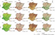
Fig. 2.
Spatial distributions of ecological evaluation indicators in 2013, 2017, and 2021. (a1-a3), normalized difference vegetation index (NDVI); (b1-b3), wetness index (WET); (c1-c3), land surface temperature (LST); (d1-d3), normalized difference bare soil index (NDBSI)."

Table 4
Correlation between principal components and original RSEI variables."
| Year | Indicator | PC1 | PC2 | PC3 | PC4 |
|---|---|---|---|---|---|
| 2013 | NDVI | 0.70495 | 0.67911 | 0.00771 | 0.20442 |
| WET | 0.17190 | -0.42692 | 0.35910 | 0.81193 | |
| LST | -0.39045 | 0.41461 | 0.81965 | -0.06184 | |
| NDBSI | -0.56661 | 0.42970 | -0.44628 | 0.54328 | |
| Eigenvalue | 0.01472 | 0.00463 | 0.00154 | 0.00037 | |
| Contribution rate (%) | 69.22 | 21.77 | 7.26 | 1.73 | |
| 2017 | NDVI | 0.61882 | 0.77001 | -0.10776 | 0.11191 |
| WET | 0.10345 | -0.19069 | 0.21934 | 0.95122 | |
| LST | -0.47513 | 0.48719 | 0.73247 | -0.01956 | |
| NDBSI | -0.61694 | 0.36519 | -0.63542 | 0.28683 | |
| Eigenvalue | 0.01742 | 0.00447 | 0.00180 | 0.00020 | |
| Contribution rate (%) | 72.89 | 18.72 | 7.51 | 0.85 | |
| 2021 | NDVI | 0.74901 | 0.66139 | 0.03352 | 0.02059 |
| WET | 0.12055 | -0.18854 | 0.97036 | 0.09123 | |
| LST | -0.65073 | 0.72590 | 0.22261 | -0.00778 | |
| NDBSI | -0.03162 | 0.00927 | -0.08787 | 0.99559 | |
| Eigenvalue | 0.01078 | 0.00380 | 0.00087 | 0.00000 | |
| Contribution rate (%) | 69.74 | 24.60 | 5.62 | 0.02 |
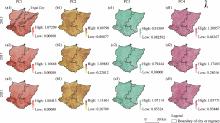
Fig. 3.
Spatial distributions of PC1 (a1-a3), PC2 (b1-b3), PC3 (c1-c3), and PC4 (d1-d3) in 2013, 2017, and 2021. PC1, the first principal component; PC2, the second principal component; PC3, the third principal component; PC4, the fourth principal component."

Table 5
Ecological evaluation results using RSEI in 2013, 2017, and 2021."
| Region | Category of ecological quality index | Area (hm2) | ||
|---|---|---|---|---|
| 2013 | 2017 | 2021 | ||
| Whole study area | Very poor ecological quality | 1175.85 | 332.27 | 471.59 |
| Poor ecological quality | 13,066.90 | 22,256.58 | 5233.41 | |
| Average ecological quality | 101,050.70 | 115,041.58 | 53,772.58 | |
| Good ecological quality | 137,357.97 | 114,732.69 | 168,572.09 | |
| Very good ecological quality | 20,128.74 | 20,417.05 | 44,730.50 | |
| Tegal City | Very poor ecological quality | 9.38 | 48.20 | 1.41 |
| Poor ecological quality | 1313.42 | 1842.18 | 429.05 | |
| Average ecological quality | 1966.43 | 1538.99 | 2631.43 | |
| Good ecological quality | 619.15 | 476.13 | 846.15 | |
| Very good ecological quality | 0.16 | 3.02 | 0.49 | |
| Brebes Regency | Very poor ecological quality | 1164.95 | 273.58 | 471.49 |
| Poor ecological quality | 10,080.52 | 14,594.61 | 4809.04 | |
| Average ecological quality | 64,831.65 | 71,186.74 | 34,722.44 | |
| Good ecological quality | 82,224.69 | 71,576.72 | 99,726.02 | |
| Very good ecological quality | 16,065.98 | 16,736.14 | 34,638.79 | |
| Tegal Regency | Very poor ecological quality | 10.90 | 58.70 | 0.10 |
| Poor ecological quality | 2986.37 | 7661.97 | 424.37 | |
| Average ecological quality | 36,219.06 | 43,854.84 | 19,050.14 | |
| Good ecological quality | 55,133.28 | 43,155.96 | 68,846.07 | |
| Very good ecological quality | 4062.76 | 3680.91 | 10,091.70 | |

Fig. 4.
Changes in ecological quality from 2013 to 2021 in Tegal City."

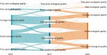
Fig. 5.
Changes in ecological quality from 2013 to 2021 in Brebes and Tegal regencies."

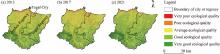
Fig. 6.
Spatial distributions of different categories of ecological quality index in 2013 (a), 2017 (b), and 2021 (c)."
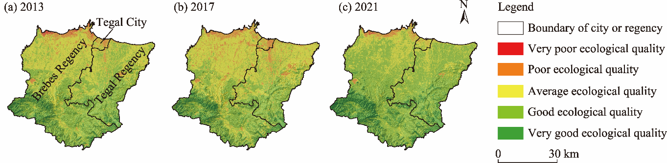
Table 6
Ecological sensitivity analysis results."
| Ecological sensitivity level | Brebes Regency | Tegal City | Tegal Regency | |||
|---|---|---|---|---|---|---|
| Area (hm2) | Percentage in the total area (%) | Area (hm2) | Percentage in the total area (%) | Area (hm2) | Percentage in the total area (%) | |
| Very high ecological sensitivity | 84,068.04 | 48.21 | 1070.00 | 27.38 | 45,922.62 | 46.66 |
| High ecological sensitivity | 60,318.82 | 34.59 | 1281.41 | 32.79 | 28,425.61 | 28.88 |
| Moderate ecological sensitivity | 16,260.66 | 9.33 | 1249.94 | 31.98 | 8439.45 | 8.58 |
| Light ecological sensitivity | 5564.77 | 3.19 | 85.80 | 2.20 | 3916.39 | 3.98 |
| Non-ecological sensitivity | 8155.52 | 4.68 | 221.37 | 5.66 | 11,708.31 | 11.90 |
| Total | 174,367.79 | 100.00 | 3908.53 | 100.00 | 98,412.38 | 100.00 |
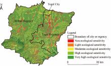
Fig. 7.
Spatial distribution of ecological sensitivity in the study area."
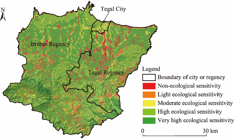
Table 7
Area and percentage of ecological constraint zone, conditional urban development zone, and urban development zone in Tegal City, Brebes Regency, and Tegal Regency."
| Environmental protection priority zone | Tegal City | Brebes Regency | Tegal Regency | |||
|---|---|---|---|---|---|---|
| Area (hm2) | Percentage in the total area (%) | Area (hm2) | Percentage in the total area (%) | Area (hm2) | Percentage in the total area (%) | |
| First priority zone (ecological constraint zone) | 1070.01 | 27.38 | 107,644.67 | 61.73 | 52,355.96 | 53.20 |
| Second priority zone (conditional urban development zone) | 1468.47 | 37.57 | 56,293.57 | 32.28 | 36,549.42 | 37.14 |
| Third priority zone (urban development zone) | 1370.05 | 35.05 | 10,429.55 | 5.98 | 9507.00 | 9.66 |
| Total | 3908.53 | 100.00 | 174,367.79 | 100.00 | 98,412.38 | 100.00 |
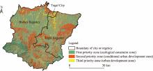
Fig. 8.
Spatial distribution of different environmental protection priority zones in this study area."

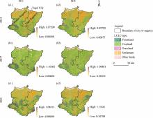
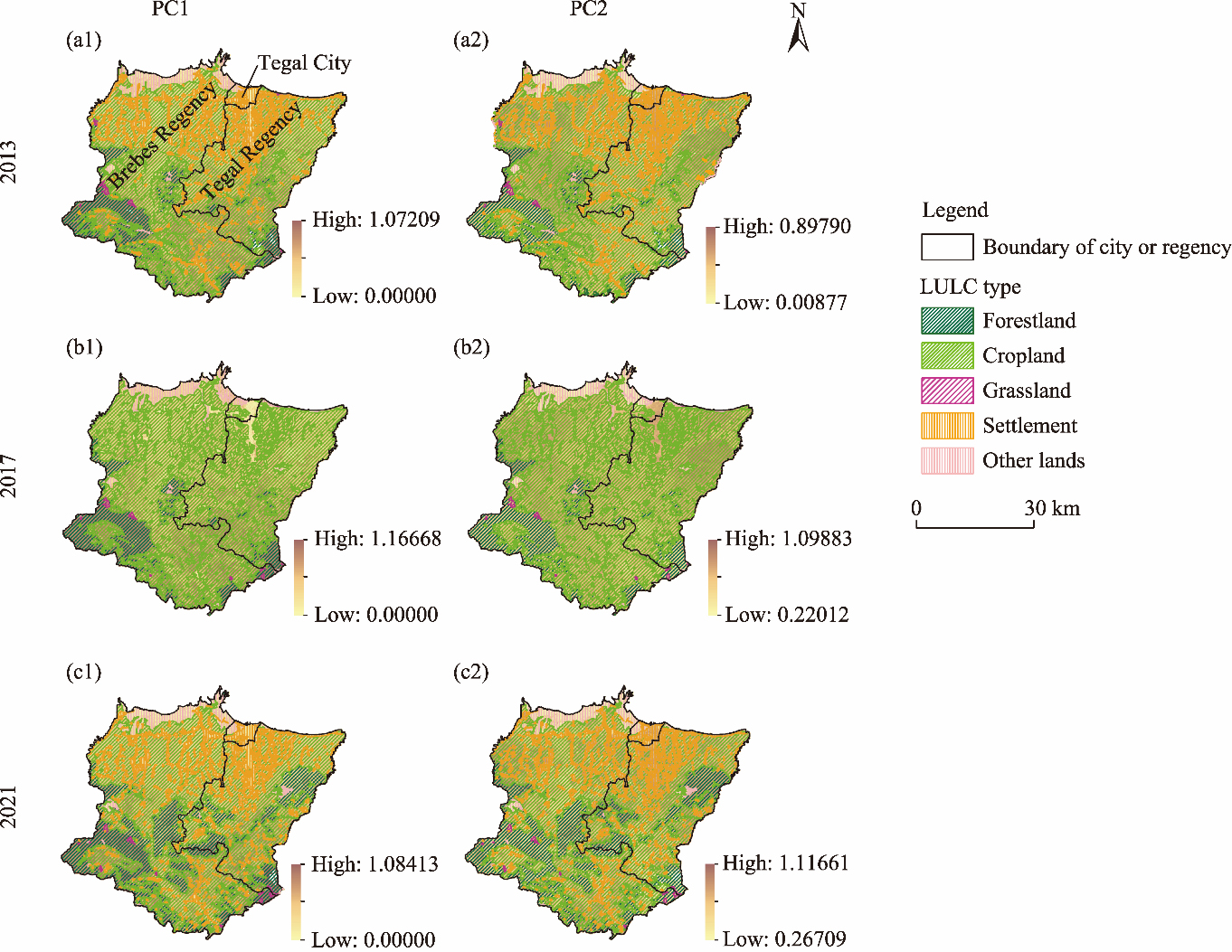
Fig. 9.
Spatial distributions of land use and land cover (LULC) types overlapping with PC1 and PC2 in 2013 (a1 and a2), 2017 (b1 and b2), and 2021 (c1 and c2)."
| [1] | Andari, M.T., Pravitasari, A.E., Anwar, S., 2022. Urban sprawl analysis as a recommendation for spatial utilization control for agricultural land development in Karawang Regency. Journal of Regional and Rural Development Planning. 6(1), 74-88. |
| [2] | Arsyad, S., 2010. Soil and Water Conservation. Bogor: IPB Press. |
| [3] | Bakshi, A., Esraz-Ul-Zannat, M., 2023. Application of delineation based on a neural network approach and landscape metrics for Khulna City, Bangladesh. Heliyon. 9, e16272, doi: 10.1016/j.heliyon.2023.e16272. |
| [4] | Basuki, I., Adinugroho, W.C., Utomo, N.A., et al., 2022. Reforestation opportunities in Indonesia: Mitigating climate change and achieving sustainable development goals. Forests. 13(3), 447, doi: 10.3390/f13030447. |
| [5] | Bell, D., Jayne, M., 2009. Small cities? Towards a research agenda. Int J. Urban Reg. Res. 33(3), 683-699. |
| [6] | Bin Sulaiman, F., 2023. Compact city: What is the extent of our exploration for its meanings? A systematic review. Sustainability. 15(13), 10302, doi: 10.3390/su151310302. |
| [7] | Chen, D., Liu, R.R., Zhou, M.X., 2023. Delineation of urban growth boundary based on habitat quality and carbon storage: A case study of Weiyuan County in Gansu, China. Land. 12(5), 1006, doi: 10.3390/land12051006. |
| [8] | Chen, J., Wang, S.S., Zou, Y.T., 2022. Construction of an ecological security pattern based on ecosystem sensitivity and the importance of ecological services: A case study of the Guanzhong Plain urban agglomeration, China. Ecol. Indic. 136, 108688, doi: 10.1016/j.ecolind.2022.108688. |
| [9] | Chen, J.Y., Xue, J.F., Gu, K., et al., 2024. Balancing urban expansion with ecological integrity: An ESP framework for rapidly urbanizing small and medium-sized cities, with insights from Suizhou, China. Ecol. Inform. 80, 102508, doi: 10.1016/j.ecoinf.2024.102508. |
| [10] | Dadi, W., Mulugeta, M., Semie, N., 2024. Impact of urbanization on the welfare of farm households: Evidence from Adama Rural District in Oromia regional state, Ethiopia. Heliyon. 10(1), e23802, doi: 10.1016/j.heliyon.2023.e23802. |
| [11] | Das, M., Das, A., Pereira, P., 2023. Developing an integrated urban ecological efficiency framework for spatial ecological planning: A case on a tropical mega metropolitan area of the global south. Geosci. Front. 14(1), 101489, doi: 10.1016/j.gsf.2022.101489. |
| [12] | Earth Resources Observation and Science (EROS) Center, 2018. USGS EROS Archive - Digital Elevation - Shuttle Radar Topography Mission (SRTM). [2024-05-03]. https://www.usgs.gov/centers/eros/science/usgs-eros-archive-digital-elevation-shuttle-radar-topography-mission-srtm. |
| [13] | Fahmi, F.Z., Hudalah, D., Rahayu, P., et al., 2014. Extended urbanization in small and medium-sized cities: The case of Cirebon, Indonesia. Habitat Int. 42, 1-10. |
| [14] | Feng, H.D., Zhang, X.G., Nan, Y., et al., 2023. Ecological sensitivity assessment and spatial pattern analysis of land resources in Tumen River Basin, China. Appl. Sci. 15, 4197, doi: 10.3390/app13074197. |
| [15] | Fitri, T.Y., Adiwibowo, S., Pravitasari, A.E., 2022. The impact of land-use changes and economic losses of paddy field conversion: A case study of Ciampea Sub-district, Bogor Regency, West Java Province. In: The 2nd International Seminar on Natural Resources and Environmental Management. IOP Conference Series: Earth and Environmental Science. 012104, doi: 10.1088/1755-1315/950/1/012104. |
| [16] | Fuadina, L.N., Rustiadi, E., Pravitasari, A.E., 2020. The dynamic of land use changes and regional development in Bandung Metropolitan Area. In: The 6th International Conference of Jabodetabek. IOP Conference Series: Earth and Environmental Science. 012002, doi: 10.1088/1755-1315/556/1/012002. |
| [17] | Fuadina, L.N, Rustiadi, E., Pravitasari, A.E., 2021. Driving factors affecting urban sprawl in Bandung Metropolitan Area. Tataloka. 23(1), 105-114. |
| [18] | Gao, Q., Fang, C.L., Liu, H.M., et al., 2021. Conjugate evaluation of sustainable carrying capacity of urban agglomeration and multi-scenario policy regulation. Sci. Total Environ. 785, 147373, doi: 10.1016/j.scitotenv.2021.147373. |
| [19] | Huang, C., Wylie, B., Yang, L., et al., 2002. Derivation of a tasselled cap transformation based on Landsat 7 at-satellite reflectance. Int. J. Remote Sens. 23(8), 1741-1748. |
| [20] | Indonesian Geospatial Information Agency, 2020. Land Use and Land Cover (LULC). [2024-05-01]. https://www.big.go.id/. |
| [21] | Indonesia’s National Board for Disaster Management, 2024. inaRISK. [2024-05-01]. https://inarisk.bnpb.go.id/. |
| [22] | Jaya, B., Rustiadi, E., Fauzi, A., et al., 2021. Land conversion and availability of agricultural land in 2035 in Puncak Area Bogor Regency. In: International e-Conference on Sustainable Agriculture and Farming System. IOP Conference Series: Earth and Environmental Science. 012059, doi: 10.1088/1755-1315/694/1/012052. |
| [23] | Kong, L.Q., Tian, G.J., Ma, B.G., et al., 2017. Embedding ecological sensitivity analysis and new satellite town construction in an agent-based model to simulate urban expansion in the Beijing metropolitan region, China. Ecol. Indic. 82, 233-249. |
| [24] | Kumari, R., Raman, R., 2022. Regional disparities in healthcare services in Uttar Pradesh, India: A principal component analysis. GeoJournal. 87(6), 5027-5050. |
| [25] | Lago-Olveira, S., Ouhemi, H., Idrissi, O., et al., 2024. Promoting more sustainable agriculture in the Moroccan drylands by shifting from conventional wheat monoculture to a rotation with chickpea and lentils. Clean. Env. Syst. 12, 100169, doi: 10.1016/j.cesys.2024.100169. |
| [26] | Li, J.G., Lei, J., Li, S.H., et al., 2022. Spatiotemporal analysis of the relationship between urbanization and the eco-environment in the Kashgar metropolitan area, China. Ecol. Indic. 135, 108524, doi: 10.1016/j.ecolind.2021.108524. |
| [27] | Li, J.Y., Gong, J., Guldmann, J.M., et al., 2021. Assessment of urban ecological quality and spatial heterogeneity based on remote sensing: A case study of the rapid urbanization of Wuhan City. Remote Sens. 13(21), 4440, doi: 10.3390/rs13214440. |
| [28] | Liu, X.Y., Wei, M., Li, Z.G., et al., 2022. Multi-scenario simulation of urban growth boundaries with an ESP-FLUS model: A case study of the Min Delta region, China. Ecol. Indic. 135, 108538, doi: 10.1016/j.ecolind.2022.108538. |
| [29] | Liu, X.Y., Su, Y., Li, Z.G., et al., 2023. Constructing ecological security patterns based on ecosystem services trade-offs and ecological sensitivity: A case study of Shenzhen metropolitan area, China. Ecol. Indic. 154, 110626, doi: 10.1016/j.ecolind.2023.110626. |
| [30] | Liu, Y.S., Zhou, Y., 2021. Territory spatial planning and national governance system in China. Land Use Pol. 102, 105288, doi: 10.1016/j.landusepol. 2021.105288. |
| [31] | Mardiansjah, F.H., 2020. Extended urbanization in smaller-sized cities and small town development in Java: The case of the Tegal Region. In: International Conference on Planning towards Sustainability. IOP Conference Series: Earth and Environmental Science. 012030, doi: 10.1088/1755-1315/447/1/012030. |
| [32] | Ministry of Agrarian Affairs and Spatial Planning Republic of Indonesia, 2021. Regulation Number 1589/SK-HK.02.01/XII/2021 about Establishment of Protected Paddy Field Maps in Districts/Cities in West Sumatra Province, Banten Province, West Java Province, Central Java Province, Special Region of Yogyakarta Province, East Java Province, Bali Province, and West Nusa Tenggara Province. [2024-05-03]. https://www.atrbpn.go.id/ (in Indonesian). |
| [33] | Ministry of Environment and Forestry Republic of Indonesia, 2019. Regulation Number 6605/MENLHK-PKTL/KUH/PLA.2/11/2019 about Map of Forest Area in Central Java Province. [2024-05-03]. https://sigap.menlhk.go.id/ (in Indonesian). |
| [34] | Ministry of Public Works and Housing Republic of Indonesia, 2015. Regulation Number 28/PRT/M/ 2015 about Determination of River Boundary Line and Lake Boundary Line. [2024-05-03]. https://peraturan.bpk.go.id/Details/159992/permen-pupr-no-28prtm2015-tahun-2015 (in Indonesian). |
| [35] | Pravitasari, A.E., Rustiadi, E., Mulya, S.P., et al., 2018. Identifying the driving forces of urban expansion and its environmental impact in Jakarta-Bandung mega urban region. In: The 4th International Symposium on LAPAN-IPB Satellite for Food Security and Environmental Monitoring. IOP Conference Series: Earth and Environmental Science. 012044, doi: 10.1088/1755-1315/149/1/012044. |
| [36] | Pravitasari, A.E., Suhada, A., Mulya, S.P., et al., 2019. Land use/cover changes and spatial distribution pattern of rice field decreasing trend in Serang Regency, Banten Province. In: The 1st International Seminar on Natural Resources and Environmental Management. IOP Conference Series: Earth and Environmental Science. 012033, doi: 10.1088/1755-1315/399/1/012033. |
| [37] | Pravitasari, A.E., Rustiadi, E., Priatama, R.A., et al., 2021. Spatiotemporal distribution patterns and local driving factors of regional development in Java. ISPRS Int. J. Geo-Inf. 10(12), 812, doi: 10.3390/ijgi10120812. |
| [38] | Pravitasari, A.E., Priatama, R.A., Mulya, S.P., et al., 2022. Local sustainability performance and its spatial interdependency in urbanizing Java island: The case of Jakarta-Bandung mega urban region. Sustainability. 14(21), 13913, doi: 10.3390/su142113913. |
| [39] | Pravitasari, A.E., Indraprahasta, G.S., Rustiadi, E., et al., 2024. Dynamics and predictions of urban expansion in Java, Indonesia: Continuity and change in mega-urbanization. ISPRS Int. J. Geo-Inf. 13(3), 102, doi: 10.3390/ijgi13030102. |
| [40] | Presidential Regulation of the Republic of Indonesia, 2016. Regulation Number 51 of 2016 about Coastal Line Boundaries. [2024-05-05]. https://peraturan.bpk.go.id/Details/40463/perpres-no-51-tahun-2016 (in Indonesian). |
| [41] | Qin, Z.L., Sha, Z.Y., 2023. Modeling the impact of urbanization and climate changes on terrestrial vegetation productivity in China by a neighborhood substitution analysis. Ecol. Model. 482, 110405, doi: 10.1016/j.ecolmodel.2023.110405. |
| [42] | Rahmad, R., Suib, S., Nurman, A., 2018. GIS application for mapping landslide threat levels in Sibolangit District, Deli Serdang Regency, North Sumatera. Majalah Geografi Indonesia. 32(1), doi: 10.22146/mgi.31882 (in Indonesian). |
| [43] | Redman, C.L., Jones, N.S., 2005. The environmental, social, and health dimensions of urban expansion. Popul. Env. 26(6), 505-520. |
| [44] | Richards, D.R., Thompson, B.S., 2019. Urban ecosystems: A new frontier for payments for ecosystem services. People Nat. 1(2), 249-261. |
| [45] | Rustiadi, E., Pravitasari, A.E., Setiawan, Y., et al., 2021. Impact of continuous Jakarta megacity urban expansion on the formation of the Jakarta-Bandung conurbation over the rice farm regions. Cities. 111, 103000, doi: 10.1016/j.cities. 2020.103000. |
| [46] | Seddon, A.W.R., Macias-Fauria, M., Long, P.R., et al., 2016. Sensitivity of global terrestrial ecosystems to climate variability. Nature. 531, 229-232. |
| [47] | Shawly, H., 2022. Evaluating compact city model implementation as a sustainable urban development tool to control urban sprawl in the city of Jeddah. Sustainability. 14(20), 13218, doi: 10.3390/su142013218. |
| [48] | Shore, T., 2020. What are urban growth boundaries and why do we need them? Greenbelt Alliance. [2024-05-18]. https://www.greenbelt.org/blog/what-are-urban-growth-boundaries-need/. |
| [49] | Silva, J.D.E., Correia, M., 2023. The main drivers of urban sprawl in Portuguese medium cities between 2001 and 2011. Land Use Pol. 132, 106803, doi: 10.1016/j.landusepol.2023.106803. |
| [50] | Sobrino, J.A., Jiménez-Muñoz, J.C., Paolini, L., 2004. Land surface temperature retrieval from LANDSAT TM 5. Remote Sens. Environ. 90(4), 434-440. |
| [51] | Soo, K.T., 2007. Zipf’s law and urban growth in Malaysia. Urban Stud. 44(1), 1-14. |
| [52] | Statistics Indonesia, 2018. Indonesia’s Population Projection 2015-2045 by SUPAS 2015. [2024-05-18]. https://www.bps.go.id/id/publication/2018/10/19/78d24d9020026ad95c6b5965/proyeksi-penduduk-indonesia-2015-2045-hasil-supas-2015.html (in Indonesian). |
| [53] | Sun, T.T., Lin, W.P., Chen, G.S., et al., 2016. Wetland ecosystem health assessment through integrating remote sensing and inventory data with an assessment model for the Hangzhou Bay, China. Sci. Total Environ. 566, 627-640. |
| [54] | Tegal City Government, 2021. Regulation Number 1 of 2021 about Amendment to Tegal City Regional Regulation No. 4/2012 on Tegal City Regional Spatial Plan 2011-2031. [2024-05-18]. https://peraturan.bpk.go.id/Details/185543/perda-kota-tegal-no-1-tahun-2021. |
| [55] | Townshend, J.R.G., Justice, C.O., 1986. Analysis of the dynamics of African vegetation using the normalized difference vegetation index. Int. J. Remote Sens. 7(11), 1435-1445. |
| [56] | UN-Habitat, 2022a. World Cities Report 2022:Envisaging the Future of Cities. [2024-05-05]. https://unhabitat.org/world-cities-report-2022-envisaging-the-future-of-cities. |
| [57] | UN-Habitat, 2022b. ASEAN Sustainable Urbanization Report 2022: Sustainable Cities toward 2025 and Beyond. [2024-05-20]. https://unhabitat.org/asean-sustainable-urbanisation-report. |
| [58] | Wang, S.B., Li, Z.Y., Long, Y., et al., 2024. Impacts of urbanization on the spatiotemporal evolution of ecological resilience in the Plateau Lake Area in Central Yunnan, China. Ecol. Indic. 160, 111836, doi: 10.1016/j.ecolind.2024.111836. |
| [59] | Wang, Z.W., Chen, T., Zhu, D.Y., et al., 2023. RSEIFE: A new remote sensing ecological index for simulating the land surface eco-environment. J. Environ. Manage. 326(A), 116851, doi: 10.1016/j.jenvman.2022.116851. |
| [60] | Wardana, A.P., Pravitasari, A.E, Panuju, D.R., 2023. Dynamics of land cover, development level, and regional typology of Central Java Province based on Sustainable Development Index. In: The 3rd International Seminar of Natural Resources and Environmental Management. IOP Conference Series: Earth and Environmental Science. 012035, doi: 10.1088/1755-1315/1266/1/012035. |
| [61] | Wirawan, B., Tambunan, J.R., 2018. Challenges on Java’s small city spatial planning. In: The 1st ITB Centennial and 4th PlanoCosmo International Conference. IOP Conference Series: Earth and Environmental Science. 012054, doi: 10.1088/1755-1315/158/1/012054. |
| [62] | Xu, H.Q., Wang, M.Y., Shi, T.T., et al., 2018. Prediction of ecological effects of potential population and impervious surface increases using a remote sensing based ecological index (RSEI). Ecol. Indic. 93, 730-740. |
| [63] | Xu, Y., Liu, R., Xue, C.B., et al., 2023. Ecological sensitivity evaluation and explanatory power analysis of the Giant Panda National Park in China. Ecol. Indic. 146, 109792, doi: 10.1016/j.ecolind.2022.109792. |
| [64] | Yang, S., Su, H., 2023. Evaluation of urban ecological environment quality based on Google Earth engine: A case study in Xi’an, China. Pol. J. Environ. Stud. 32(1), 927-942. |
| [65] | Yang, X.D., Bai, Y.P., Che, L., et al., 2021. Incorporating ecological constraints into urban growth boundaries: A case study of ecologically fragile areas in the Upper Yellow River. Ecol. Indic. 124, 107436, doi: 10.1016/j.ecolind.2021.107436. |
| [66] | Yuan, G.N., Marquez, G.P.B., Deng, H.R., et al., 2022. A review on urban agriculture: Technology, socio-economy, and policy. Heliyon. 8, e11583, doi: 10.1016/j.heliyon.2022.e11583. |
| [67] | Yuniasih, B., Harahap, W.N., Wardana, D.A.S., 2023. El Niño and La Niña climate anomalies in Indonesia during 2013-2022. Agroista Jurnal Agroteknologi. 6(2), 136-143 (in Indonesian). |
| [68] | Zhang, H., Wang, Z.Q., Chai, J., 2022a. Land use∖cover change and influencing factors inside the urban development boundary of different level cities: A case study in Hubei Province, China. Heliyon. 8(9), e10408, doi: 10.1016/j.heliyon.2022.e10408. |
| [69] | Zhang, Z., Hu, B.Q., Qiu, H.H., 2022b. Comprehensive evaluation of resource and environmental carrying capacity based on SDGs perspective and three-dimensional Balance Model. Ecol. Indic. 138, 108788, doi: 10.1016/j.ecolind.2022.108788. |
| Viewed | ||||||
|
Full text |
|
|||||
|
Abstract |
|
|||||
 REGSUS Wechat
 新公网安备 65010402001202号