Regional Sustainability ›› 2023, Vol. 4 ›› Issue (3): 332-348.doi: 10.1016/j.regsus.2023.08.004cstr: 32279.14.j.regsus.2023.08.004
• Full Length Article • Previous Articles
LI Guoyia, LIU Jiahonga,b,*( ), SHAO Weiweia
Received:2023-01-28
Revised:2023-05-21
Accepted:2023-08-23
Published:2023-09-30
Online:2023-10-20
Contact:
*E-mail address: LI Guoyi, LIU Jiahong, SHAO Weiwei. Urban flood risk assessment under rapid urbanization in Zhengzhou City, China[J]. Regional Sustainability, 2023, 4(3): 332-348.
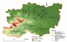
Fig. 1.
Location and physiographic information of Zhengzhou City."

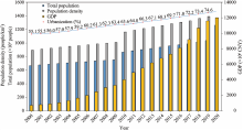
Fig. 2.
Development trends of population and GDP of Zhengzhou City from 2000 to 2020."

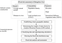
Fig. 3.
Flood risk assessment framework for Zhengzhou City."

Table 1
Judgment matrix of hazard index in the urban flood risk assessment system of Zhengzhou City."
| Average annual rainfall | Distance to river | Weight | |
|---|---|---|---|
| Average annual rainfall | 1 | 1/3 | 0.75 |
| Distance to river | 3 | 1 | 0.25 |
Table 2
Judgment matrix of vulnerability index in the urban flood risk assessment system of Zhengzhou City."
| Land use/land cover (LULC) | GDP | Population density | Weight | |
|---|---|---|---|---|
| LULC | 1 | 1/4 | 1/3 | 0.13 |
| GDP | 4 | 1 | 1 | 0.49 |
| Population density | 3 | 1 | 1 | 0.38 |
Table 3
Judgment matrix of exposure index in the urban flood risk assessment system of Zhengzhou City."
| Elevation | Slope | Normalized Difference Vegetation Index (NDVI) | Weight | |
|---|---|---|---|---|
| Elevation | 1 | 1/2 | 1/4 | 0.18 |
| Slope | 2 | 1 | 3/4 | 0.33 |
| NDVI | 4 | 4/3 | 1 | 0.49 |
Table 4
Judgment matrix of quasi-survey layer in the urban flood risk assessment system of Zhengzhou City."
| Vulnerability | Exposure | Hazard | Weight | |
|---|---|---|---|---|
| Vulnerability | 1 | 1/4 | 1/3 | 0.13 |
| Exposure | 4 | 1 | 5/4 | 0.49 |
| Hazard | 3 | 4/5 | 1 | 0.38 |
Table 5
Weight of each indicator and index in the urban flood risk assessment system of Zhengzhou City."
| Object layer | Index layer | Indictor layer | Weight of indictor | Weight of index |
|---|---|---|---|---|
| Urban flood risk assessment | Hazard | Average annual rainfall | 0.75 | 0.38 |
| Distance to river | 0.25 | |||
| Vulnerability | Elevation | 0.18 | 0.13 | |
| Slope | 0.33 | |||
| NDVI | 0.49 | |||
| Exposure | Population density | 0.44 | 0.49 | |
| GDP | 0.39 | |||
| LULC | 0.17 |
Table 6
Detailed information of each indicator factor in the urban flood risk assessment system of Zhengzhou City."
| Indicator factor | Data source | Year | Format |
|---|---|---|---|
| Average annual rainfall | National Meteorological Information Center ( | 2000-2020 | TXT |
| Distance to river | Calculated from elevation data (GIS) | 12.5 m×12.5 m raster | |
| Elevation | Resources and Environment Science and Data Center, Chinese Academy of Sciences ( | 12.5 m×12.5 m raster | |
| Slope | Calculated from elevation data (GIS) | 12.5 m×12.5 m raster | |
| NDVI | Resources and Environment Science and Data Center, Chinese Academy of Sciences ( | 2000, 2005, 2010, 2015, and 2020 | 1 km×1 km raster |
| Population density | Resources and Environment Science and Data Center, Chinese Academy of Sciences ( | 2000, 2005, 2010, 2015, and 2020 | 1 km×1 km raster |
| GDP | Resources and Environment Science and Data Center, Chinese Academy of Sciences ( | 2000, 2005, 2010, 2015, and 2020 | 1 km×1 km raster |
| LULC | GlobelLand30 ( | 2000, 2010, and 2020 | 1 km×1 km raster |
| Resource and Environmental Science and Data Center, Chinese Academy of Sciences ( | 2005 and 2015 | 30 m×30 m raster |
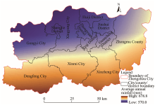
Fig. 4.
Spatial distribution of average rainfall in Zhengzhou City."
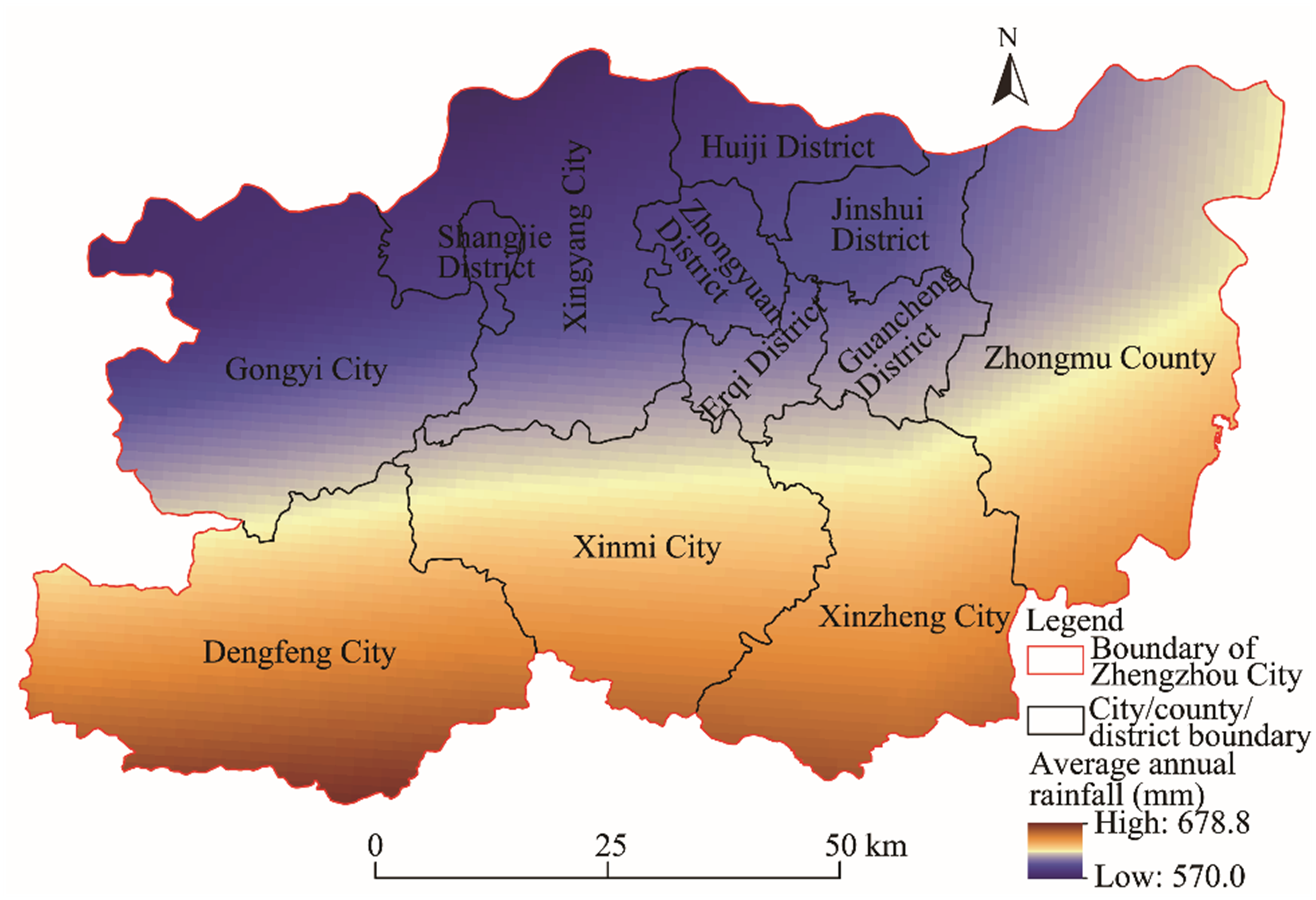
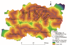
Fig. 5.
Distribution of distance to river in Zhengzhou City."

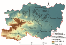
Fig. 6.
Spatial distribution of elevation in Zhengzhou City."

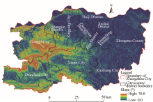
Fig. 7.
Spatial distribute of slope in Zhengzhou City."

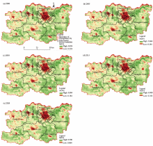
Fig. 8.
Spatiotemporal distribution of vegetation cover (indicated by NDVI) in Zhengzhou City in 2000 (a), 2005 (b), 2010 (c), 2015 (d), and 2020 (e)."

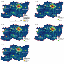
Fig. 9.
Spatiotemporal distribution of population density in Zhengzhou City in 2000 (a), 2005 (b), 2010 (c), 2015 (d), and 2020 (e)."

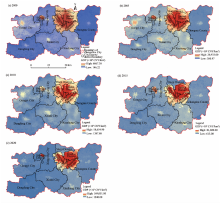
Fig. 10.
Spatiotemporal distribution of GDP in Zhengzhou City in 2000 (a), 2005 (b), 2010 (c), 2015 (d), and 2020 (e)."

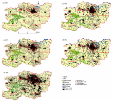
Fig. 11.
Spatiotemporal distribution of LULC in Zhengzhou City in 2000 (a), 2005 (b), 2010 (c), 2015 (d), and 2020 (e). Due to the different data sources and resolutions (Table 6), the images of 2000, 2010, and 2020 were distinguished with the images of 2005 and 2015."

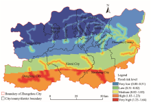
Fig. 12.
Hazard-wised flood risk spatial distribution of Zhengzhou City."

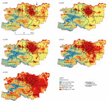
Fig. 13.
Vulnerability-wised flood risk spatiotemporal distribution of Zhengzhou City in 2000 (a), 2005 (b), 2010 (c), 2015 (d), and 2020 (e)."

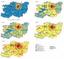
Fig. 14.
Exposure-wised flood risk spatiotemporal distribution of Zhengzhou City in 2000 (a), 2005 (b), 2010 (c), 2015 (d), and 2020 (e)."

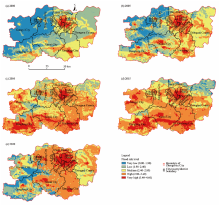
Fig. 15.
Spatiotemporal distribution of flood risk in Zhengzhou City in 2000 (a), 2005 (b), 2010 (c), 2015 (d), and 2020 (e)."

Table 7
Area percentage of different flood risk levels in Zhengzhou City."
| Flood risk level | Percentage of flood risk level (%) | ||||
|---|---|---|---|---|---|
| 2000 | 2005 | 2010 | 2015 | 2020 | |
| Very high | 0.004 | 0.317 | 0.382 | 0.521 | 1.139 |
| High | 1.358 | 4.953 | 4.554 | 11.630 | 23.087 |
| Medium | 9.051 | 41.086 | 37.184 | 55.513 | 54.321 |
| Low | 49.790 | 42.653 | 42.628 | 31.774 | 21.268 |
| Very low | 39.797 | 10.991 | 15.252 | 0.562 | 0.185 |
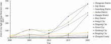
Fig. 16.
Changes of the area of very high flood risk and high flood risk zones of the 12 cities, county, and districts in Zhengzhou City from 2000 to 2020."

| [1] | Aghapour A.H., Yazdani M., Jolai F., et al., 2019. Capacity planning and reconfiguration for disaster-resilient health infrastructure. J. Build. Eng. 26, 100853, doi: 10.1016/j.jobe.2019.100853. |
| [2] | Bera A., Taloor A.K., Meraj G., et al., 2021. Climate vulnerability and economic determinants: Linkages and risk reduction in Sagar Island, India; A geospatial approach. Quaternary Science Advances. 4, 100038, doi: 10.1016/j.qsa.2021.100038. |
| [3] |
Calvet L., Wang D.D., Juan A., et al., 2019. Solving the multidepot vehicle routing problem with limited depot capacity and stochastic demands. Int. Trans. Oper. Res. 26(2), 458-484.
doi: 10.1111/itor.2019.26.issue-2 |
| [4] |
Camorani G., Castellarin A., Brath A., 2005. Effects of land-use changes on the hydrologic response of reclamation systems. Phys. Chem. Earth. 30(8-10), 561-574.
doi: 10.1016/j.pce.2005.07.010 |
| [5] | Fariza A., Basofi A., Prasetyaningrum I., et al., 2020. Urban flood risk assessment in Sidoarjo, Indonesia, using fuzzy multi-criteria decision making. Journal of Physics: Conference Series. 1444, 012027, doi: 10.1088/1742-6596/1444/1/012027. |
| [6] | Feng L.T., 2020. Research on risk assessment of flood disaster in Zhengzhou City based on RS and GIS. Master Thesis. Zhengzhou: Zhengzhou University (in Chinese). |
| [7] | Ghosh A., Kar S.K., 2018. Application of analytical hierarchy process (AHP) for flood risk assessment: a case study in Malda district of West Bengal, India. Nat. Hazards. 94, 349-368. |
| [8] | Haasnoot M., Middelkoop H., Offermans A., et al., 2012. Exploring pathways for sustainable water management in river deltas in a changing environment. Clim. Change. 115, 795-819. |
| [9] | Halgamuge M.N., Nirmalathas A., 2017. Analysis of large flood events: Based on flood data during 1985-2016 in Australia and India. Int. J. Disaster Risk Reduct. 24, 1-11. |
| [10] | Huang G.R., 2018. Discrimination of relationship between urban storm waterlogging prevention and sponge city construction. China Flood & Drought Management. 28(2), 8-14 (in Chinese). |
| [11] | Huang G.R., Luo H.W., Chen W.J., et al., 2019. Scenario simulation and risk assessment of urban flood in Donghaochong basin, Guangzhou. Advances in Water Science. 30(5), 643-652 (in Chinese). |
| [12] | Kazakis N., Kougias I., Patsialis T., 2015. Assessment of flood hazard areas at a regional scale using an index-based approach and Analytical Hierarchy Process: Application in Rhodope-Evros region, Greece. Sci. Total Environ. 538, 555-563. |
| [13] | Kia M.B., Pirasteh S., Pradhan B., et al., 2012. An artificial neural network model for flood simulation using GIS: Johor River Basin, Malaysia. Environ. Earth Sci. 67, 251-264. |
| [14] | Kumar M.D., Tandon S., Bassi N., et al., 2021. A framework for risk-based assessment of urban floods in coastal cities. Nat. Hazards. 110, 2035-2057. |
| [15] | Kundzewicz Z.W., Kanae S., Seneviratne S.I., et al., 2014. Flood risk and climate change: global and regional perspectives. Hydrol. Sci. J.-J. Sci. Hydrol. 59(1), 1-28. |
| [16] | Lei X.X., Chen W., Panahi M., et al., 2021. Urban flood modeling using deep-learning approaches in Seoul, South Korea. J. Hydrol. 61, 126684, doi: 10.1016/j.jhydrol.2021.126684. |
| [17] | Li Z.H., Song K.Y., Peng L., 2021. Flood risk assessment under land use and climate change in Wuhan City of the Yangtze River Basin, China. Land. 10(8), 878, doi: 10.3390/land10080878. |
| [18] |
Liu J.H., Li Z.J., Mei C., et al., 2019. Urban flood analysis for different design storm hyetographs in Xiamen Island based on TELEMAC-2D. Chin. Sci. Bull. 64(19), 2055-2066 (in Chinese).
doi: 10.1360/N972018-01180 |
| [19] | Liu J.H., Luo Z.R., Zhang Y.X., et al., 2022. Influence of urbanization on spatial distribution of extreme precipitation in Henan Province. Water Resources Protection. 38(1), 100-105 (in Chinese). |
| [20] | Liu J.H., Pei Y.J., Mei C., et al., 2023. Waterlogging cause and disaster prevention and control of “7·20” torrential rain in Zhengzhou. Journal of Zhengzhou City University (Engineering Science). 44(2), 38-45 (in Chinese). |
| [21] | Nandi A., Mandal A., Wilson M., et al., 2016. Flood hazard mapping in Jamaica using principal component analysis and logistic regression. Environ. Earth Sci. 75, 465, doi: 10.1007/s12665-016-5323-0. |
| [22] | Paprotny D., Kreibich H., Morales-Nápoles O., et al., 2020. Exposure and vulnerability estimation for modelling flood losses to commercial assets in Europe. Sci. Total Environ. 737, 140011, doi: 10.1016/j.scitotenv.2020.140011. |
| [23] | Park K., Won J.H., 2019. Analysis on distribution characteristics of building use with risk zone classification based on urban flood risk assessment. Int. J. Disaster Risk Reduct. 38(3), 101192, doi: 10.1016/j.ijdrr.2019.101192. |
| [24] | Pham B.T., Luu C., Dao D.V., et al., 2021. Flood risk assessment using deep learning integrated with multi-criteria decision analysis. Knowledge-Based Syst. 219, 106899, doi: 10.1016/j.knosys.2021.106899. |
| [25] | Radwan F., Alazba A.A., Mossad A., 2019. Flood risk assessment and mapping using AHP in arid and semiarid regions. Acta Geophys. 67, 215-229. |
| [26] |
Saaty T.L., 1977. A scaling method for priorities in hierarchical structures. J. Math. Psychol. 15(3), 234-281.
doi: 10.1016/0022-2496(77)90033-5 |
| [27] | Shao R., Shao W.W., Su X., et al., 2022. Impact of various flood scenarios on urban emergency responses times based on the TELEMAC-2D model. Journal of Tsinghua University (Science and Technology). 62(1), 60-69 (in Chinese). |
| [28] |
Tehrany M.S., Pradhan B., Jebur M.N., 2015. Flood susceptibility analysis and its verification using a novel ensemble support vector machine and frequency ratio method. Stoch. Environ. Res. Risk Assess. 29(4), 1149-1165.
doi: 10.1007/s00477-015-1021-9 |
| [29] | Tomar P., Singh S.K., Kanga S., et al., 2021. GIS-based urban flood risk assessment and management—a case study of Delhi National Capital Territory (NCT), India. Sustainability. 13(22), 12850, doi: 10.3390/su132212850. |
| [30] | Wang Z.L., Lai C.G., Chen X.H., et al., 2015. Flood hazard risk assessment model based on random forest. J. Hydrol. 527, 1130-1141. |
| [31] | Xu Z.X., Chen H., Ren M.F., et al., 2020. Progress on disaster mechanism and risk assessment of urban flood/waterlogging disasters in China. Advances in Water Science. 31(5), 713-724 (in Chinese). |
| [32] | Yazdani M., Mojtahedi M., Loosemore M., 2020. Enhancing evacuation response to extreme weather disasters using public transportation systems: a novel simheuristic approach. J. Comput. Des. Eng. 7(2), 195-210. |
| [33] | Yazdani M., Mojtahedi M., Loosemore M., et al., 2021. Hospital evacuation modelling: A critical literature review on current knowledge and research gaps. Int. J. Disaster Risk Reduct. 66, 102627, doi: 10.1016/j.ijdrr.2021.102627. |
| [34] | Yu Q., Wang Y.Y., Li N., 2022. Extreme flood disasters: comprehensive impact and assessment. Water. 14(8), 1211, doi: 10.3390/w14081211. |
| [35] | Zhang D.F., Shi X.G., Xu H., et al., 2020. A GIS-based spatial multi-index model for flood risk assessment in the Yangtze River Basin, China. Environ. Impact Assess. Rev. 83, 106397, doi: 10.1016/j.eiar.2020.106397. |
| [36] | Zhang J.P., Zhang H., Fang H.Y., et al., 2021. Study on the characteristics of rainstorm in Zhengzhou. Journal of China Hydrology. 41(5), 78-83 (in Chinese). |
| [37] | Zhang J.Y., Wang Y.T., He R.M., et al., 2016. Discussion on the urban flood and waterlogging and causes analysis in China. Advances in Water Science. 27(4), 485-491 (in Chinese). |
| [38] | Zhao J.H., Xu H.S., Wang T.Y., et al., 2022. Improved entropy weight-TOPSIS-grey correlation method-based urban flood-waterlogging risk assessment. Water Resources and Hydropower Engineering. 53(10), 58-73 (in Chinese). |
| [39] | Zhou Y.H., Peng T., Shi R.Q., 2019. Research progress on risk assessment of heavy rainfall and flood disasters in China. Torrential Rain and Disasters. 38(5), 494-501 (in Chinese). |
| [1] | Bubun MAHATA, Siba Sankar SAHU, Archishman SARDAR, Laxmikanta RANA, Mukul MAITY. Spatiotemporal dynamics of land use/land cover (LULC) changes and its impact on land surface temperature: A case study in New Town Kolkata, eastern India [J]. Regional Sustainability, 2024, 5(2): 100138-. |
| [2] | Liton Chandra VOUMIK, Md. Hasanur RAHMAN, Md. Maznur RAHMAN, Mohammad RIDWAN, Salma AKTER, Asif RAIHAN. Toward a sustainable future: Examining the interconnectedness among Foreign Direct Investment (FDI), urbanization, trade openness, economic growth, and energy usage in Australia [J]. Regional Sustainability, 2023, 4(4): 405-415. |
| [3] | WANG Yuchan, GAO Genghe, NING Xiaoju, LI Yuanzheng, NIU Ning, GUO Yaqi. Willingness of returning migrant workers to purchase houses: A case study of 45 villages in Henan Province, China [J]. Regional Sustainability, 2022, 3(2): 133-145. |
| [4] | Ahmed Mohammed Sayed MOHAMMED, Tetsuya UKAI, Michael HALL. Towards a sustainable campus-city relationship: A systematic review of the literature [J]. Regional Sustainability, 2022, 3(1): 53-67. |
| [5] | HE Jianjian, ZHANG Pengyan. Evaluation of carbon emissions associated with land use and cover change in Zhengzhou City of China [J]. Regional Sustainability, 2022, 3(1): 1-11. |
| [6] | Yanhua He, Yi Lin, Guohua Zhou, Yixuan Zhu, Kai Tang. Spatial pattern and drivers of urbanization in China’s mid-level developing urban agglomeration: A case study of Chang-Zhu-Tan [J]. Regional Sustainability, 2021, 2(1): 83-97. |
| [7] | Yupeng Liu, Jiajia Li, Linlin Duan, Min Dai, Wei-qiang Chen. Material dependence of cities and implications for regional sustainability [J]. Regional Sustainability, 2020, 1(1): 31-36. |
| Viewed | ||||||
|
Full text |
|
|||||
|
Abstract |
|
|||||
 REGSUS Wechat
 新公网安备 65010402001202号