Regional Sustainability ›› 2025, Vol. 6 ›› Issue (6): 100276.doi: 10.1016/j.regsus.2025.100276cstr: 32279.14.REGSUS.20250038
• Full Length Article • Previous Articles Next Articles
Purwantiningrum PURWANTININGRUMa, Ernan RUSTIADIb,c,*( ), Didit Okta PRIBADIc,d
Received:2025-01-09
Revised:2025-10-25
Accepted:2025-12-12
Published:2025-12-31
Online:2026-01-08
Contact:
* E-mail address: Purwantiningrum PURWANTININGRUM, Ernan RUSTIADI, Didit Okta PRIBADI. Mapping the spatial pattern of ecosystem services in the Jabodetabek Metropolitan Area, Indonesia: Could peri-urban areas support the urban core?[J]. Regional Sustainability, 2025, 6(6): 100276.
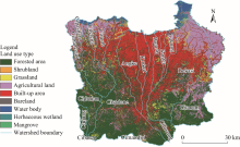
Fig. 1.
Overview of study area. The imagery of the study area was derived from European Space Agency in 2021."

Table 1
Description of the data used in this study."
| Data type | Spatial resolution | Year | Source | |
|---|---|---|---|---|
| Land use type | 30 m×30 m | 2021 | Satellite Imagery European Space Agency ( | |
| Digital elevation model (DEM) | 9 m×9 m | 2023 | Geospatial Information Agency ( | |
| Climate data | Evapotranspiration | 30 m×30 m | 2022 | Terra Moderate Resolution Imaging Spectroradiometer (MODIS) MOD16A3GF Version 6.1 |
| Urban Heat Island (UHI) effect | 30 m×30 m | 2020 | Global Surface UHI Explorer ( | |
| Temperature and precipitation | 30 m×30 m | 2023 | Meteorological, Climatological, and Geophysical Agency ( | |
| Soil hydrology | 250 m×250 m | 2020 | Global Hydrologic Soil Groups (HYSOGs250m) for Curve Number-Based Run-off Modeling ( | |
| Soil erosivity | 926 m×926 m | 2017 | European Soil Data Centre ( | |
| Soil erodibility | 1 km×1 km | 2017 | Erodibility: European Soil Data Centre ( | |
| Watershed delineation | 1: 500,000 | 2021 | Ministry of Environment and Forestry ( | |
| Biophysical data | Tabular data (crop coefficient, albedo, Universal Soil Loss Equation (USLE) value, and Curve Number value) | - | 2023 | Integrated Valuation of Ecosystem Services and Trade-offs (InVEST) ( |
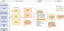
Fig. 2.
Research design flowchart. DEM, digital elevation model; InVEST, Integrated Valuation of Ecosystem Services and Trade-offs; UHM, Urban Heat Mitigation; SR, Sediment Retention; FRM, Flood Risk Mitigation; HMI, heat mitigation index; SDR, Sediment Delivery Ratio."
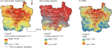
Fig. 3.
Spatial distribution of land surface temperature (a), cooling capacity (b), and HMI (c) in the Jabodetabek Metropolitan Area (JMA) in 2024."

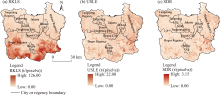
Fig. 4.
Spatial distribution of RKLS (a), USLE (b), and SDR (c) in the JMA in 2024. RKLS, rainfall-runoff erosivity factor, soil erodibility factor, length, and slope; USLE, Universal Soil Loss Equation."


Fig. 5.
Spatial distribution of sediment deposition (a), avoided erosion (b), and avoided export (c) in the JMA in 2024."
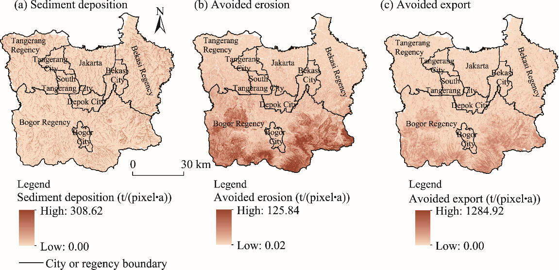

Fig. 6.
Spatial distribution of runoff retention index (a), runoff retention volume (b), and surface runoff (c) in the JMA in 2024."
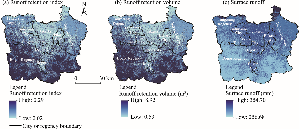
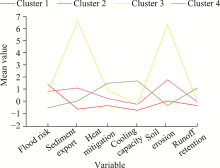
Fig. 7.
Mean value change trend of variables for the four clusters."

Table 2
Ecosystem service levels of variables for the four clusters."
| Cluster | Flood risk | Sediment export | Heat mitigation | Cooling capacity | Soil erosion | Runoff retention |
|---|---|---|---|---|---|---|
| Cluster 1 | High | Low | Low | Low | Medium | Low |
| Cluster 2 | Medium | Medium | Medium | Medium | Medium | Low |
| Cluster 3 | Medium | High | Medium | Medium | High | Medium |
| Cluster 4 | Low | Medium | High | High | Low | High |
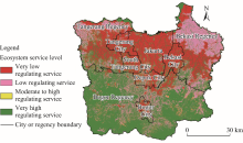
Fig. 8.
Spatial distribution of ecosystem services by administration delineation in the JMA."

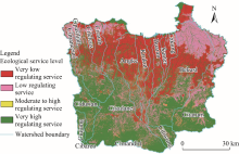
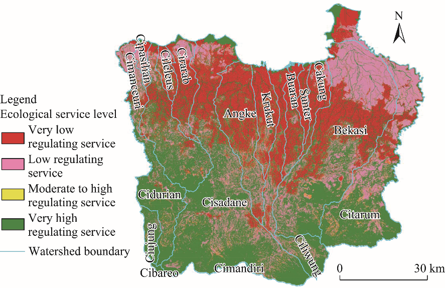
Fig. 9.
Spatial distribution of ecosystem service level by watershed delineation in the JMA."
| [1] | Amalia Wardhani, F., Pravitasari, A.E., Ridwansyah, I., 2024. Vulnerability assessment to flash floods disasters in the Upper Cisadane Watershed. Journal of Natural Resources and Environmental Management. 14(1), 1, doi: 10.29244/jpsl.14.1.1. |
| [2] | Arifien, Y., Anggarawati, S., Wibaningwati, D.B., 2021. The influence of farmer behavior and motivation in land conservation on farmers’ income in the upper Ciliwung Watershed, Bogor Regency. IOP Conference Series: Earth and Environmental Science. 686(1), 012015, doi: 10.1088/1755-1315/686/1/012015. |
| [3] | Ariyani, S., Amsyir, A., Destaniel, I., et al., 2023. Land use change in Dramaga Village, Dramaga District, Bogor Regency, West Java. In: Proceedings of the 3rd International Conference on Rural Socio-Economic Transformation: A Transdisciplinary Approach for Promoting Sustainable, Resilience, and Just Rural Transitions in the Era of Climate Crisis. Bogor, Indonesia. |
| [4] |
Bennett, E.M., Peterson, G.D., Gordon, L.J., 2009. Understanding relationships among multiple ecosystem services. Ecol. Lett. 12(12), 1394-1404.
doi: 10.1111/j.1461-0248.2009.01387.x pmid: 19845725 |
| [5] | Buffam, I., Hagemann, F.A., Emilsson, T., et al., 2022. Priorities and barriers for urban ecosystem service provision: A comparison of stakeholder perspectives from three cities. Front. Sustain. Cities. 4, 838971, doi: 10.3389/frsc.2022.838971. |
| [6] | Cao, T.G., Yi, Y.J., Liu, H.X., et al., 2021. The relationship between ecosystem service supply and demand in plain areas undergoing urbanization: A case study of China’s Baiyangdian Basin. J. Environ. Manage. 289, 112492, doi: 10.1016/j.jenvman.2021.112492. |
| [7] | Cardoso, B.H.F., Gonçalves, S., Fuadina, L.N., et al., 2017. Urban agglomeration and extension in northern coast of West Java: a transformation into mega region. IOP Conference Series: Earth and Environmental Science. 79(1), 012011, doi: 10.1088/1755-1315/79/1/012011. |
| [8] | Douglass, M., 2013. Integrated regional planning for sustainable development in Asia: Innovations in the governance of metropolitan, rural-urban, and transborder riparian regions. Regional Development Dialogue. 34(2), 11-35. |
| [9] | Evans, D.L., Falagán, N., Hardman, C.A., et al., 2022. Ecosystem service delivery by urban agriculture and green infrastructure—A systematic review. Ecosyst. Serv. 54, 101405, doi: 10.1016/j.ecoser.2022.101405. |
| [10] |
Firman, T., 2008. In search of a governance institution model for Jakarta Metropolitan Area (JMA) under Indonesia’s new decentralisation policy: old problems, new challenges. Public Adm. Dev. 28(4), 280-290.
doi: 10.1002/pad.v28:4 |
| [11] |
Gill, S.E., Handley, J.F., Ennos, A.R., et al., 2007. Adapting cities for climate change: The role of the green infrastructure. Built Environment. 33(1), 115-133.
doi: 10.2148/benv.33.1.115 |
| [12] |
Giofandi, E.A., Syahzaqi, I., Sekarjati, D., et al., 2024. Assessment of remote sensing approach for urban ecological quality evaluation in Pekanbaru City, Riau Province Indonesia. Geography, Environment, Sustainability. 17(1), 28-35.
doi: 10.24057/2071-9388-2023-2640 |
| [13] |
Grimm, N.B., Faeth, S.H., Golubiewski, N.E., et al., 2008. Global change and the ecology of cities. Science. 319(5864), 756-760.
doi: 10.1126/science.1150195 pmid: 18258902 |
| [14] | Haines-Young, R., Potschin, M., 2018. Common International Classification of Ecosystem Services (CICES) V5.1 Guidance on the Application of the Revised Structure. Nottingham: Fabis Consulting Ltd. |
| [15] | Hansen, R., Bush, J., Pribadi, D.O., et al., 2023. Planning and Maintaining Nature-Based Solutions:Lessons for Foresight and Sustainable Care from Berlin, Jakarta, Melbourne, and Santiago de Chile. Cheltenham: Edward Elgar Publishing, 215-239. |
| [16] | IPBES (Intergovernmental Science-Policy Platform on Biodiversity and Ecosystem Services), 2019. Summary for Policymakers of the IPBES Global Assessment Report on Biodiversity and Ecosystem Services. [2024-12-19]. https://www.ipbes.net/node/35274. |
| [17] | Kurniawan, T., Mayasari, I., Prasojo, U.S., 2018. Private forest as a model in critical land reconstruction in upstream area, Indonesia. IOP Conference Series: Earth and Environmental Science. 200(1), 012051, doi: 10.1088/1755-1315/200/1/012051. |
| [18] | Langemeyer, J., Madrid-Lopez, C., Mendoza Beltran, A., et al., 2021. Urban agriculture—A necessary pathway towards urban resilience and global sustainability? Landsc. Urban Plan. 210, 104055, doi: 10.1016/j.landurbplan.2021.104055. |
| [19] | Li, D.L., Wu, S.Y., Liang, Z., et al., 2020. The impacts of urbanization and climate change on urban vegetation dynamics in China. Urban Green. 54, 126764, doi: 10.1016/j.ufug.2020.126764. |
| [20] |
Li, F., Wang, R.S., Paulussen, J., et al., 2005. Comprehensive concept planning of urban greening based on ecological principles: A case study in Beijing, China. Landsc. Urban Plan. 72(4), 325-336.
doi: 10.1016/j.landurbplan.2004.04.002 |
| [21] | Li, J., Geneletti, D., Wang, H.C., 2023. Understanding supply-demand mismatches in ecosystem services and interactive effects of drivers to support spatial planning in Tianjin metropolis, China. Sci. Total Environ. 895, 165067, doi: 10.1016/j.scitotenv.2023.1650. |
| [22] | Liu, Q.Y., Liu, H.M., Xu, G., et al., 2023. Spatial gradients of supply and demand of ecosystem services within cities. Ecol. Indic. 157, 111263, doi: 10.1016/j.ecolind.2023.1112. |
| [23] |
Lourdes, K.T., Gibbins, C.N., Hamel, P., et al., 2021. A review of urban ecosystem services research in Southeast Asia. Land. 10(1), 1-21.
doi: 10.3390/land10010001 |
| [24] | Luederitz, C., Brink, E., Gralla, F., et al., 2015. A review of urban ecosystem services: six key challenges for future research. Ecosyst. Serv. 14, 98-112. |
| [25] |
Magura, T., Ferrante, M., Lövei, G.L., 2020. Only habitat specialists become smaller with advancing urbanization. Glob. Ecol. Biogeogr. 29(11), 1978-1987.
doi: 10.1111/geb.v29.11 |
| [26] | Marshall, F., Waldman, L., MacGregor, H., et al., 2009. On the Edge of Sustainability: Perspectives on Peri-Urban Dynamics. Brighton: STEPS Centre. |
| [27] | McNeill,, J.R., 2001. The atmosphere:regional and global history. In: McNeil, J.R., Demuth, B., (eds.). Something New Under the Sun: An Environmental History of the Twentieth-Century World. New York: W. W. Norton & Company, 84-117. |
| [28] | Millennium Ecosystem Assessment, 2005. Ecosystems and Human Well-Being:Synthesis. Washington: Island Press. |
| [29] | Moench, M., Gyawali, D., 2008. Desakota: Reinterpreting the Urban-Rural Continuum. [2024-12-20]. https://assets.publishing.service.gov.uk/media/57a08bc3ed915d3cfd000f14/Desakota-Part-II-A.pdf. |
| [30] | Mulya, S.P., Putro, H.P.H., Hudalah, D., 2023. Review of peri-urban agriculture as a regional ecosystem service. Geogr. Sustain. 4(3), 244-254. |
| [31] | Munajati, S.L., Kartodihardjo, H., Saleh, M.B., et al., 2019. Sensitivity analysis of ecosystem services especially food provisioning due to the dynamics of land use change in Bogor Regency, West Java, Indonesia. IOP Conference Series: Earth and Environmental Science. 399(1), 012024, doi: 10.1088/1755-1315/399/1/012024. |
| [32] | Nowak, A., Grunewald, K., 2018. Landscape sustainability in terms of landscape services in rural areas: Exemplified with a case study area in Poland. Ecol. Indic. 94, 12-22. |
| [33] |
Peng, L.X., Zhang, L.W., Li, X.P., et al., 2022. Spatial expansion effects on urban ecosystem services supply-demand mismatching in Guanzhong Plain Urban Agglomeration of China. J. Geogr. Sci. 32(5), 806-828.
doi: 10.1007/s11442-022-1973-x |
| [34] | Pravitasari, A.E., Saizen, I., Tsutsumida, N., et al., 2015. Local spatially dependent driving forces of urban expansion in an emerging Asian megacity: The case of Greater Jakarta (Jabodetabek). J. Sustain. Dev. 8(1), 108-119. |
| [35] | Pribadi, D.O., Pauleit, S., 2015. The dynamics of peri-urban agriculture during rapid urbanization of Jabodetabek Metropolitan Area. Land Use Pol. 48, 13-24. |
| [36] |
Pribadi, D.O., Vollmer, D., Pauleit, S., 2018. Impact of peri-urban agriculture on runoff and soil erosion in the rapidly developing metropolitan area of Jakarta, Indonesia. Reg. Envir. Chang. 18(7), 2129-2143.
doi: 10.1007/s10113-018-1341-7 |
| [37] |
Queiroz, C., Meacham, M., Richter, K., et al., 2015. Mapping bundles of ecosystem services reveals distinct types of multifunctionality within a Swedish landscape. Ambio. 44(1), 89-101.
doi: 10.1007/s13280-014-0601-0 |
| [38] | Ramdhan, M., Arifin, H.S., Suharnoto, Y., et al., 2018. Towards water sensitive city: Lesson learned from Bogor flood hazard in 2017. E3S Web of Conferences. 31, 09012, doi: 10.1051/e3sconf/20183109012. |
| [39] | Raudsepp-Hearne, C., Peterson, G.D., Bennett, E.M., 2010. Ecosystem service bundles for analyzing tradeoffs in diverse landscapes. Proc. Natl. Acad. Sci. U.S.A. 107(11), 5242-5247. |
| [40] | Rustiadi, E., Kobayashi, S., 2000. Contiguous spatial classification: A new approach on quantitative zoning. Journal Geography Education. 43, 29-35. |
| [41] | Sadewo, E., Syabri, I., Pradono, 2018. Beyond the early stage of post-suburbanization: Evidence from urban spatial transformation in Jabodetabek Metropolitan Area. IOP Conference Series: Earth and Environmental Science. 158(1), 012040, doi: 10.1088/1755-1315/158/1/012040. |
| [42] | Saridewi, T.R., Nazaruddin, 2018. The economic benefits of vegetation in the upstream area of Ciliwung watershed. IOP Conference Series: Earth and Environmental Science. 144(1), 012052, doi: 10.1088/1755-1315/144/1/012052. |
| [43] |
Saridewi, T.R., Fauzi, A., 2019. A market-based mechanism as an alternative solution for watershed management: A case study of the Ciliwung Watershed, Indonesia. International Journal of Global Environmental Issues. 18(2), 171-186.
doi: 10.1504/IJGENVI.2019.102304 |
| [44] | Setiawan, G., Syaufina, L., Puspaningsih, N., 2016. Estimation of carbon stock loss from land use changes in Bogor Regency. J. Silvik. Trop. 7(2), 79-85. |
| [45] | Tan, P.N., Steinbach, M., Kumar, V., 2006. Introduction to Data Mining: Instructor’s Solution Manual. New Jersey: Pearson Addison-Wesley. |
| [46] | The Natural Capital Project, 2020. InVEST: Integrated Valuation of Ecosystem Services and Tradeoffs. [2024-12-19]. https://naturalcapitalproject.stanford.edu/software/invest. |
| [47] | Trihono, K., 2019. Erosion in the Bekasi Watershed and Its Impact on Flooding. [2024-12-20]. https://osf.io/5qjkd/ (in Indonesia). |
| [48] | Veriasa, T.O., Rustiadi, E., Kinseng, R.A., 2020. The impact of joint community forest management (PHBM) on local community income in upstream of Ciliwung Watershed, Bogor Regency-Indonesia. IOP Conference Series: Earth and Environmental Science. 556(1), 012009, doi: 10.1088/1755-1315/556/1/012009. |
| [49] | Vindigni, G., Mosca, A., Bartoloni, T., et al., 2021. Shedding light on peri-urban ecosystem services using automated content analysis. Sustainability. 13(16), 9182, doi: 10.3390/su13169182. |
| [50] | Vollmer, D., Pribadi, D.O., Remondi, F., et al., 2016. Prioritizing ecosystem services in rapidly urbanizing river basins: A spatial multi-criteria analytic approach. Sust. Cities Soc. 20, 237-252. |
| [51] |
Wang, S.J., Li, G.D., Fang, C.L., 2018. Urbanization, economic growth, energy consumption, and CO2 emissions: Empirical evidence from countries with different income levels. Renew. Sust. Energ. Rev. 81, 2144-2159.
doi: 10.1016/j.rser.2017.06.025 |
| [52] | Xin, R.H., Skov-Petersen, H., Zeng, J., et al., 2021. Identifying key areas of imbalanced supply and demand of ecosystem services at the urban agglomeration scale: A case study of the Fujian Delta in China. Sci. Total Environ. 791, 148173, doi: 10.1016/j.scitotenv.2021.148173. |
| [53] |
Yokohari, M., Takeuchi, K., Watanabe, T., et al., 2000. Beyond greenbelts and zoning: A new planning concept for the environment of Asian mega-cities. Landsc. Urban Plan. 47(3-4), 159-171.
doi: 10.1016/S0169-2046(99)00084-5 |
| [1] | Osman ZAKARI, Charles GYAMFI, Samuel Anim OFOSU, Ebenezer BOAKYE, Solomon Tawiah APAFO, Geophrey Kwame ANORNU, Bernard Nuoleyeng BAATUUWIE. Effects of land use and land cover changes on ecosystem services and functions in the Kulpawn River Basin of Ghana [J]. Regional Sustainability, 2025, 6(6): 100277-. |
| [2] | FENG Xuyu, ZHAO Xiao, TONG Ling, WANG Sufen, DING Risheng, KANG Shaozhong. Impacts of land use and cover change on carbon storage: Multi-scenario projections in the arid region of Northwest China [J]. Regional Sustainability, 2025, 6(4): 100248-. |
| [3] | Abdul MALIK, Muhammad Ichsan ALI, Abdul Rasyid JALIL, Abdul MANNAN, Rahma MUSYAWARAH. Promoting sustainable mangrove tourism through payments for ecosystem services: Insights from Tongke-Tongke Village, South Sulawesi, Indonesia [J]. Regional Sustainability, 2025, 6(2): 100213-. |
| [4] | Wassie Abuhay ASCHENEFE, Temesgen Gashaw TAREKEGN, Betelhem Fetene ADMAS, Solomon Mulu TAFERE. Quantifying the impacts of land use/land cover changes on ecosystem service values in the upper Gilgel Abbay watershed, Ethiopia [J]. Regional Sustainability, 2025, 6(1): 100197-. |
| [5] | Jafarpour Ghalehteimouri KAMRAN, Che Ros FAIZAH, Rambat SHUIB. Application of Cellular Automata and Markov Chain model for urban green infrastructure in Kuala Lumpur, Malaysia [J]. Regional Sustainability, 2024, 5(4): 100179-. |
| [6] | Setyardi Pratika MULYA, Delik HUDALAH. Agricultural intensity for sustainable regional development: A case study in peri-urban areas of Karawang Regency, Indonesia [J]. Regional Sustainability, 2024, 5(1): 100117-. |
| [7] | WU Fan, LIANG Youjia, LIU Lijun, YIN Zhangcai, HUANG Jiejun. Identifying eco-functional zones on the Chinese Loess Plateau using ecosystem service bundles [J]. Regional Sustainability, 2023, 4(4): 425-440. |
| [8] | Sabir HUSSAIN, Sheenu SHARMA, Anand Narain SINGH. Evaluation of ecosystem supply services and calculation of economic value in Kargil District [J]. Regional Sustainability, 2022, 3(2): 157-169. |
| [9] | Mobeen Akhtar, Yuanyuan Zhao, Guanglei Gao, Qudsia Gulzar, Azfar Hussain, Abdus Samie. Assessment of ecosystem services value in response to prevailing and future land use/cover changes in Lahore, Pakistan [J]. Regional Sustainability, 2020, 1(1): 37-47. |
| Viewed | ||||||
|
Full text |
|
|||||
|
Abstract |
|
|||||
 REGSUS Wechat
 新公网安备 65010402001202号