
Regional Sustainability ›› 2026, Vol. 7 ›› Issue (4): 100372.doi: 10.1016/j.regsus.2026.100372
• Research article • Previous Articles Next Articles
JIN Jingyua,b,c,d, LI Junlia,c,*( ), BAO Anminga,c, WEI Chunxiae, LI Fujiea,b,f,g, WANG Haoyua,b,c, ZHANG Jiudana,b,c, Naibi SULEIa,b,c
Received:2025-07-17
Revised:2026-02-01
Accepted:2026-07-15
Published:2026-08-30
Online:2026-08-05
Contact:
*E-mail address: lijl@ms.xjb.ac.cn (LI Junli).
JIN Jingyu, LI Junli, BAO Anming, WEI Chunxia, LI Fujie, WANG Haoyu, ZHANG Jiudan, Naibi SULEI. Spatiotemporal variations in oasis structure and landscape stability in the middle reaches of the Konqi River based on high-spatial-resolution multispectral imagery[J]. Regional Sustainability, 2026, 7(4): 100372.
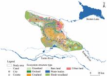
Fig. 1.
Location of the study area."
Table 1
List of remote sensing datasets."
| Year | Data type | Spatial resolution (m) | Count | Acquisition date | Data quality | Data source |
|---|---|---|---|---|---|---|
| 1986 | SPOT-1 | 20.0 | 3 | 13 June 1986 and 30 August 1986 | Cloudless | https://regards.cnes.fr/user/swh/modules/60 |
| 2003 | SPOT-4 | 10.0 | 3 | 30 September 2003 and 25 October 2003 | ||
| 2008 | SPOT-4 | 10.0 | 3 | 02 September 2008 and 24 October 2008 | ||
| 2011 | SPOT-4 | 10.0 | 3 | 02 July 2011, 23 July 2011, and 07 August 2011 | ||
| 2023 | Sentinel-2 | 10.0 | 3 | 10 September 2023, 15 October 2023, and 20 October 2023 | https://scihub.copernicus. eu/dhus/#/home | |
| 2023 | GF-2 | 0.8 | 12 | 07 June 2023, 27 June 2023, 07 July 2023, 30 August 2023, and 04 September 2023 | https://data.cresda.cn |
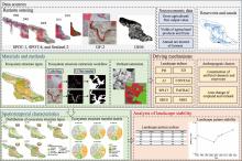
Fig. 2.
Flowchart of this study. SPOT, Système Probatoire d’Observation de la Terre; GF-2, GaoFen-2; DEM, digital elevation model; PD, patch density; ED, edge density; AI, aggregation index; CONTAG, contagion; SPLIT: splitting index; PAFRAC: perimeter-area fractal dimension; SHDI, Shannon diversity index; SHEI, Shannon evenness index."

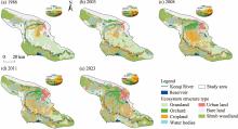
Fig. 3.
Distribution of ecosystem structure types in the middle reaches of the Konqi River in 1986 (a), 2003 (b), 2008 (c), 2011 (d), and 2023 (e). The pie chart represents the area percentage distribution of various ecological structure types."

Table 2
Area changes and dynamic change proportion of ecosystem structure types in the middle reaches of the Konqi River during 1986-2023."
| Ecosystem structure type | 1986-2003 | 2003-2008 | 2008-2011 | 2011-2023 | 1986-2023 | |||||
|---|---|---|---|---|---|---|---|---|---|---|
| Area change (km2) | Change proportion (%) | Area change (km2) | Change proportion (%) | Area change (km2) | Change proportion (%) | Area change (km2) | Change proportion (%) | Area change (km2) | Change proportion (%) | |
| Grassland | -111.45 | -7.12 | -536.92 | -36.92 | -97.55 | -10.63 | -162.86 | -19.86 | -908.78 | -58.04 |
| Cropland | 362.85 | 47.93 | 472.23 | 42.16 | 156.90 | 9.85 | 93.66 | 5.35 | 1085.65 | 143.39 |
| Orchard | 42.76 | 114.43 | 120.74 | 181.97 | 30.28 | 11.91 | 139.83 | 47.98 | 336.76 | 901.30 |
| Shrub woodland | -248.74 | -18.17 | -35.86 | -3.20 | -76.71 | -7.07 | -12.54 | -1.24 | -373.85 | -27.30 |
| Urban land | 8.01 | 9.60 | 81.93 | 89.61 | 42.32 | -24.41 | 149.46 | 69.30 | 281.72 | 337.73 |
| Bare land | -51.29 | -3.14 | -122.61 | -7.76 | -49.65 | -3.41 | -193.59 | -13.75 | -417.14 | -25.57 |
| Water bodies | -2.15 | -1.78 | -4.56 | -3.86 | -2.21 | -1.94 | 4.55 | 4.08 | -4.37 | -3.63 |
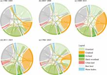
Fig. 4.
Chordal diagrams of the ecosystem structure transfer matrix during 1986-2003 (a), 2003-2008 (b), 2008-2011 (c), 2011-2023 (d), and 1986-2023 (e). The area of the water bodies here includes the area of the reservoirs and the Konqi River. The thickness of the curves in the chord diagram indicates the extent of change, and thicker curves represent more significant changes."

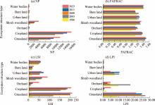
Fig. 5.
Landscape pattern indices calculated for each ecosystem structure type in 1986, 2003, 2008, 2011, and 2023. (a), number of patches (NP); (b), PAFRAC; (c), landscape shape index (LSI); (d), largest patch index (LPI)."
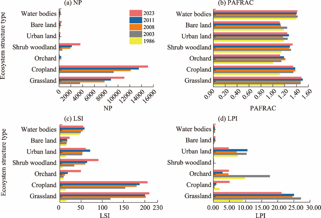
Table 3
Changes in landscape pattern indices in the middle reaches of the Konqi River during 1986-2023."
| Year | PD | ED | AI | CONTAG | PAFRAC | SPLIT | SHDI | SHEI |
|---|---|---|---|---|---|---|---|---|
| 1986 | 0.04 | 4.09 | 99.81 | 66.96 | 1.30 | 5.65 | 1.36 | 0.65 |
| 2003 | 2.47 | 45.56 | 97.71 | 56.78 | 1.20 | 8.4 | 1.56 | 0.80 |
| 2008 | 4.01 | 66.66 | 96.67 | 53.63 | 1.19 | 13.78 | 1.64 | 0.84 |
| 2011 | 4.55 | 71.36 | 96.44 | 53.16 | 1.19 | 12.88 | 1.65 | 0.85 |
| 2023 | 5.50 | 79.14 | 96.05 | 51.22 | 1.19 | 17.75 | 1.70 | 0.87 |
Table 4
Standardised matrix of four key landscape pattern indices during 1986-2023."
| Year | PAFRAC | SHDI | PD | SPLIT |
|---|---|---|---|---|
| 1986 | 1.00 | 0.00 | 1.00 | 1.00 |
| 2003 | 0.10 | 0.60 | 0.55 | 0.77 |
| 2008 | 0.02 | 0.84 | 0.27 | 0.33 |
| 2011 | 0.03 | 0.85 | 0.17 | 0.40 |
| 2023 | 0.00 | 1.00 | 0.00 | 0.00 |
Table 5
Expression of principal components of four key landscape pattern indices."
| Principal component (PC) | PAFRAC | SHDI | PD | SPLIT |
|---|---|---|---|---|
| PC1 | 0.29 | 0.57 | -0.56 | -0.53 |
| PC2 | 0.91 | 0.03 | 0.14 | 0.39 |
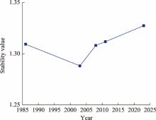
Fig. 6.
Curve of landscape pattern stability during 1986-2023."
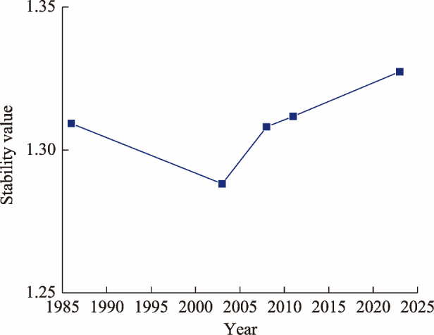
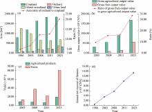
Fig. 7.
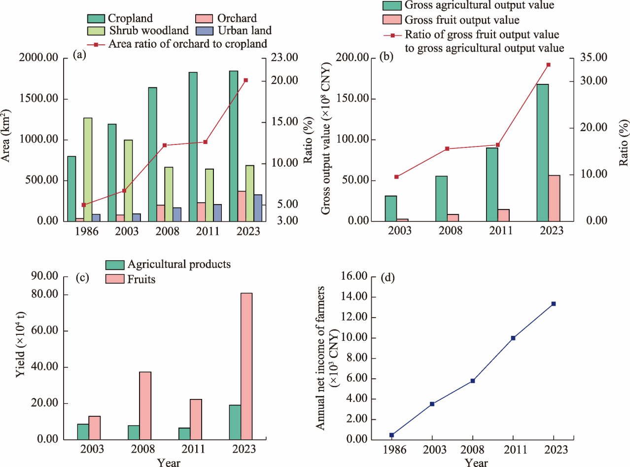
Temporal changes in ecosystem structure and socioeconomic indicators in the middle reaches of the Konqi River. (a), changes in the areas of cropland, orchard, shrub woodland, and urban land, and the area ratio of orchard to cropland from 1986 to 2023; (b), gross agricultural output value, gross fruit output value, and the ratio of gross fruit output value to gross agricultural output value from 2003 to 2023; (c), yields of agricultural products and fruits from 2003 to 2023; (d), annual net income of farmers in the middle reaches of the Konqi River from 1986 to 2023."
| [1] | Abdi A.M., 2020. Land cover and land use classification performance of machine learning algorithms in a boreal landscape using Sentinel-2 data. GIScience & Remote Sensing. 57(1), 1-20. |
| [2] | Almadini A.M., Hassaballa A.A., 2019. Depicting changes in land surface cover at Al-Hassa oasis of Saudi Arabia using remote sensing and GIS techniques. PloS ONE. 14(11), e0221115, doi: 10.1371/journal.pone.0221115. |
| [3] |
Bie Q., Xie Y.W., 2020. The constraints and driving forces of oasis development in arid region: A case study of the Hexi Corridor in northwest China. Scientific Reports. 10(1), 17708, doi: 10.1038/s41598-020-74930-z.
pmid: 33077843 |
| [4] | Bayingol Mongolian Autonomous Prefecture Bureau of Statistics, 2005. Bayingol Statistical Yearbook (2004). Beijing: China Statistics Press, 54-157 (in Chinese). |
| [5] | Bayingol Mongolian Autonomous Prefecture Bureau of Statistics, 2010. Bayingol Statistical Yearbook (2009). Beijing: China Statistics Press, 28-129 (in Chinese). |
| [6] | Bayingol Mongolian Autonomous Prefecture Bureau of Statistics, 2013. Bayingol Statistical Yearbook (2012). Beijing: China Statistics Press, 22-130 (in Chinese). |
| [7] | Bayingol Mongolian Autonomous Prefecture Bureau of Statistics, 2024. Statistical Communiqué on Economic and Social Development of Bayingol Mongolian Autonomous Prefecture (2023). [2025-06-02]. https://www.xjbz.gov.cn/xjbz/c101602/202408/0a96c7e56aac4fd28e2b4b03fd386ac4.shtml. (in Chinese). |
| [8] | Chang C., Bao A.M., Li J.L., 2016. Driving analysis of the spatial and temporal evolution of cultivated land in the four-source area of the Tarim River. Arid Zone Research. 33(2), 239-245 (in Chinese). |
| [9] |
Chen G.Z., Li X., Liu X.P., et al., 2020. Global projections of future urban land expansion under shared socioeconomic pathways. Nature Communications. 11(1), 537, doi: 10.1038/s41467-020-14386-x.
pmid: 31988288 |
| [10] | Chen P., Wang S., Liu Y.X., et al., 2022. Spatio-temporal patterns of oasis dynamics in China’s drylands between 1987 and 2017. Environmental Research Letters. 17(6), 064044, doi: 10.1088/1748-9326/ac740b. |
| [11] | Chen Y.N., Chen Z.S., 2013. Analysis of oasis evolution and suitable development scale for arid regions: A case study of the Tarim River Basin. Chinese Journal of Eco-Agriculture. 21(1), 134-140 (in Chinese). |
| [12] | Dong J.W., Wu W.B., Huang J.X., et al., 2020. State of the art and perspective of agricultural land use remote sensing information extraction. Journal of Geo-information Science. 22(4), 772-783 (in Chinese). |
| [13] | Du Q., Xu H.L., Ling H.B., et al., 2014. Changes in land use/cover change and fragmentation of landscape in the Kaidou-Kongque River valley in recent 20 years. Journal of Ecology and Rural Environment. 30(6), 795-799 (in Chinese). |
| [14] | Erb A.M., Li Z., Sun Q.S., et al., 2022. Evaluation of the Landsat-8 albedo product across the circumpolar domain. Remote Sensing. 14(21), 5320, doi: 10.3390/rs14215320. |
| [15] | Fang Y.L., Wu S.X., Hou G.Y., et al., 2024. Spatiotemporal changes and driving mechanisms of cropland reclamation and abandonment in Xinjiang. Land. 13(9), 1476, doi: 10.3390/land13091476. |
| [16] |
Gaur S., Mittal A., Bandyopadhyay A., et al., 2020. Spatio-temporal analysis of land use and land cover change: a systematic model inter-comparison driven by integrated modelling techniques. International Journal of Remote Sensing. 41(23), 9229-9255.
doi: 10.1080/01431161.2020.1815890 |
| [17] | He J.P., 2018. Spatio-temporal change and driving force mechanism of oasis in the Kaidu-Kongqi River basin over the past 30 years. PhD Dissertation. Urumqi: Xinjiang University (in Chinese). |
| [18] |
He Y.C., Wei G.H., 2022. Evaluation of ecological water conveying benefit in the Populus euphratica forest area in the Peacock river basin. Ground Water. 44(5), 119-122 (in Chinese).
doi: 10.1111/gwat.2006.44.issue-1 |
| [19] | He Y.H., Yang J., Guo X.L., 2020. Green vegetation cover dynamics in a heterogeneous grassland: Spectral unmixing of landsat time series from 1999 to 2014. Remote Sensing. 12(22), 3826, doi: 10.3390/rs12223826. |
| [20] | Heath J.T., Grimmett L., Gopalakrishnan T., et al., 2024. Integrating sentinel 2 imagery with high-resolution elevation data for automated inundation monitoring in vegetated floodplain wetlands. Remote Sensing. 16(13), 2434, doi: 10.3390/rs16132434. |
| [21] | Huang Z., Liu X.G., Yang Q., et al., 2021. Quantifying the spatiotemporal characteristics of multi-dimensional karst ecosystem stability with Landsat time series in southwest China. International Journal of Applied Earth Observation and Geoinformation. 104, 102575, doi: 10.1016/j.jag.2021.102575. |
| [22] | Jin R.C., Lu H.J., Yuan X.W., et al., 2023. Study on the popularization and application of conservation tillage technology of winter wheat+silage corn under drip irrigation in Bazhou, Xinjiang. Farm Machinery. (2), 88-93, 96 (in Chinese). |
| [23] | Kang W.P., Liu S.L., Chen X., et al., 2022. Evaluation of ecosystem stability against climate changes via satellite data in the eastern sandy area of northern China. Journal of Environmental Management. 308, 114596, doi: 10.1016/j.jenvman.2022.114596. |
| [24] | Kashyap R., Kuttippurath J., Patel V.K., 2025. Agriculture intensification and moisture-induced Thar desert greening: implications for energy balance, socio-economy, and biodiversity. GIScience & Remote Sensing. 62(1), 2483458, doi: 10.1080/15481603.2025.2483458. |
| [25] | Li W.H., Wu L., Ma Y.Q., et al., 2019. Analysis of ecological water transmission of Kongque River based on the connection of river-lake-reservoir water system. Desert and Oasis Weather. 13(1), 130-135 (in Chinese). |
| [26] | Li X.Y., Zhu C.G., Ma Y.Q., et al., 2021. Research on ecological base flow and natural vegetation water demand in the Kongque River basin of Xinjiang. Arid Land Geography. 44(2), 337-345 (in Chinese). |
| [27] | Liao N., Wang Y.J., Xu H.L., et al., 2021. Differences in and driving forces of cultivated land expansion in the Manas River Basin oasis, Xinjiang. Chinese Journal of Eco-Agriculture. 29(6), 1008-1017 (in Chinese). |
| [28] |
Liu L., Chen Y.P., Li X.Y., 2021. Effect of ecological water conveyance on groundwater depth and vegetation in the Kongque River. Arid Zone Research. 38(4), 901-909 (in Chinese).
doi: 10.13866/j.azr.2021.04.01 |
| [29] |
Long H.L., Tang G.P., Li X.B., et al., 2007. Socio-economic driving forces of land-use change in Kunshan, the Yangtze River Delta economic area of China. Journal of Environmental Management. 83(3), 351-364.
pmid: 16824673 |
| [30] | Lv Z.H., Shi Y.S., Guo D.F., et al., 2022. High-resolution daily emission inventory of biomass burning in the Amur-Heilong River Basin based on MODIS fire radiative energy data. Remote Sensing. 14(16), 4087, doi: 10.3390/rs14164087. |
| [31] |
Ma H., Zhao W.J., Li F.H., et al., 2023. Study on remote sensing image classification of oasis area based on ENVI deep learning. Polish Journal of Environmental Studies. 32(3), 2231-2242.
doi: 10.15244/pjoes/160190 |
| [32] | Ma L., Yang S., Gu Q., et al., 2019. Spatial and temporal mapping of cropland expansion in northwestern China with multisource remotely sensed data. CATENA. 183, 104192, doi: 10.1016/j.catena.2019.104192. |
| [33] |
Mas J.F., Gao Y., Pacheco J.A.N., 2010. Sensitivity of landscape pattern metrics to classification approaches. Forest Ecology and Management. 259(7), 1215-1224.
doi: 10.1016/j.foreco.2009.12.016 |
| [34] |
Moreno-Mateos D., Mander Ü., Comín F.A., et al., 2008. Relationships between landscape pattern, wetland characteristics, and water quality in agricultural catchments. Journal of Environmental Quality. 37(6), 2170-2180.
doi: 10.2134/jeq2007.0591 pmid: 18948470 |
| [35] | Mustafa A., Cools M., Saadi I., et al., 2017. Coupling agent-based, cellular automata and logistic regression into a hybrid urban expansion model (HUEM). Land Use Policy. 69, 529-540. |
| [36] | Naik S.S., Masilamani P., Kushawaha J., et al., 2024. Investigating the impact of land use land cover change on groundwater level dynamics in the Koraiyar watershed, Coimbatore district, Tamil Nadu, India. Frontiers in Water. 6, 1339613, doi: 10.3389/frwa.2024.1339613/full. |
| [37] | Peng Z.X., Liu S.M., Liu R., et al., 2025. Simulating oasis-desert interactions in artificial and natural oasis-desert areas: Integration of remote sensing data and CFD methodology. Agricultural and Forest Meteorology. 367, 110516, doi: 10.1016/j.agrformet.2025.110516. |
| [38] | Song Q., Feng C.H., Ma Z.Q., et al., 2022. Simulation of land use change in oasis of arid areas based on Landsat images from 1990 to 2019. Remote Sensing for Natural Resources. 34(1), 198-209. |
| [39] | Suir G.M., Jackson S., Saltus C., et al., 2023. Multi-temporal trend analysis of coastal vegetation using metrics derived from hyperspectral and LiDAR data. Remote Sensing. 15(8), 2098, doi: 10.3390/rs15082098. |
| [40] | Tang Y.Y., Yan E.P., Tang Y.B., et al., 2025. Research on label-free super-resolution land cover mapping based on deep learning. Journal of Southwest Forestry University. 45(5), 147-154 (in Chinese). |
| [41] |
Verburg P.H., Soepboer W., Veldkamp A., et al., 2002. Modelling the spatial dynamics of regional land use: the CLUE-S model. Environmental Management. 30(3), 391-405.
pmid: 12148073 |
| [42] | Wang C.F., Zhang F., Cheng J.B., et al., 2024a. Development status quo, problems and countermeasures of Korla balsam pear industry. Journal of Fruit Tree Resources. 5(5), 88-91. |
| [43] | Wang H.Y., Li J.L., Shen Z.F., et al., 2024b. Improving semantic segmentation accuracy in thin cloud interference scenarios by mixing simulated cloud-covered samples. International Journal of Applied Earth Observation and Geoinformation. 133, 104087, doi: 10.1016/j.jag.2024.104087. |
| [44] | Wang T., 2010. Some issues on oasification study in China. Journal of Desert Research. 30(5), 995-998 (in Chinese). |
| [45] | Wang X.Q., Lin M.Q., Ding Z., et al., 2020. Ecological health assessment of Kaikong River Basin based on automatic screening of indicators in Xinjiang. Acta Ecologica Sinica. 40(13), 4302-4315 (in Chinese). |
| [46] |
Wang Y., Chen Y.N., Ding J.L., et al., 2015. Land-use conversion and its attribution in the Kaidu-Kongqi River Basin, China. Quaternary International. 380-381, 216-223.
doi: 10.1016/j.quaint.2014.10.010 |
| [47] | Xie Y.C., Gong J., Qian D.W., 2015. Discussion of quantitative methods on oasis spatio-temporal change. Arid Zone Research. 32(6), 1247-1254 (in Chinese). |
| [48] |
Xue J., Gui D.W., Zhao Y., et al., 2015. Quantification of environmental flow requirements to support ecosystem services of oasis areas: a case study in Tarim Basin, Northwest China. Water. 7(10), 5657-5675.
doi: 10.3390/w7105657 |
| [49] | Xue J., Gui D.W., Lei J.Q., et al., 2019. Oasification: An unable evasive process in fighting against desertification for the sustainable development of arid and semiarid regions of China. CATENA. 179, 197-209. |
| [50] | Yan Y.J., Li J.G., Li J.L., et al., 2023. Spatio-temporal measurement and driving factor analysis of ecosystem service trade-offs and synergy in the Kaidu-Kongque River Basin, Xinjiang, China. Sustainability. 15(16), 12164, doi: 10.3390/su151612164. |
| [51] | Yang G., Li F.D., Chen D., et al., 2019. Assessment of changes in oasis scale and water management in the arid Manas River Basin, north western China. Science of The Total Environment. 691, 506-515. |
| [52] | Yuan P.L., Wang C.W., Zhao Q.Z., et al., 2021. Monitoring land use and changes in cold and arid regions based on deep learning using multi-temporal imagery, a case study of the Mosuowan reclamation area in Xinjiang. Arid Land Geograph. 44(6), 1717-1728 (in Chinese). |
| [53] |
Zhang J., Ma K., Fan H., et al., 2024a. Land cover change and its response to water level around Tonle Sap Lake in 1988-2020. Journal of Geographical Sciences. 34(2), 329-354.
doi: 10.1007/s11442-024-2207-1 |
| [54] | Zhang J., Zhang P., Deng X.Y., et al., 2024b. Study on the spatial and temporal trends of ecological environment quality and influencing factors in Xinjiang oasis. Remote Sensing. 16(11), 1980, doi: 10.3390/rs16111980. |
| [55] |
Zhang J., Xu C.C., Wang H.Y., et al., 2025. Runoff simulation and hydropower resource prediction of the Kaidu River Basin in the Tianshan Mountains, China. Journal of Arid Land. 17(1), 1-18.
doi: 10.1007/s40333-025-0071-1 |
| [56] |
Zhang J.F., Meng F.H., Bao A.M., et al., 2018. LUCC analysis of the upstream of the Kongqi River, Xinjiang, China. Journal of Desert Research. 38(3), 664-672 (in Chinese).
doi: 10.7522/j.issn.1000-694X.2016.00185 |
| [57] | Zhang Z.P., Xia F.Q., Yang D.G., et al., 2020. Spatiotemporal characteristics in ecosystem service value and its interaction with human activities in Xinjiang, China. Ecological Indicators. 110, 105826, doi: 10.1016/j.ecolind.2019.105826. |
| [58] | Zhao N., Du L., Tian S.C., et al., 2025. Cropland expansion masks ecological degradation: The unsustainable greening of China’s Drylands. Agronomy. 15(5), 1162, doi: 10.3390/agronomy15051162. |
| [59] |
Zhao W.Z., Zhuang Y.L., 2008. Study on oasis stability in arid zones of China. Arid Zone Research. 25(2), 155-162 (in Chinese).
doi: 10.3724/SP.J.1148.2008.00155 |
| [60] |
Zhou D.Y., Wang X.J., Shi M.J., 2017a. Human driving forces of oasis expansion in northwestern China during the last decade - A case study of the Heihe River basin. Land Degradation & Development. 28(2), 412-420.
doi: 10.1002/ldr.v28.2 |
| [61] | Zhou H.H., Wumaierjiang W., Hao X.M., et al., 2017b. Estimation of ecological water demand of natural vegetation in the Peacock River Basin. Environment Development and Sustainability. 42(2), 140-144 (in Chinese). |
| [62] | Zhu H.X., Li J.R., Xiao H.J., et al., 2026. Dynamics of oases in East Asia in the 21st century: Insights from China and Mongolia. Ecological Indicators. 187, 114-155. |
| [1] | HAO Jiaxin, SHEN Liqiang, WANG Yuejian, CHEN Huanhuan. Spatiotemporal evolution and simulation optimization of rural settlements in Hotan Prefecture, China: A three-dimensional perspective [J]. Regional Sustainability, 2026, 7(4): 100371-. |
| [2] | FAN Zhitao, DONG Fawu, LIU Dongwei, LI Bingjie, QU Zhicheng, YAO Shunyu, SU Xiashu, WANG Lixin. Estimates of grassland carbon storage using machine-learning models [J]. Regional Sustainability, 2026, 7(3): 100352-. |
| [3] | Rizal IMANA, Andrea Emma PRAVITASARI, Didit Okta PRIBADI. Analysis of environmental protection priority zones and their impacts on urban planning in small- and medium-sized cities of Indonesia [J]. Regional Sustainability, 2025, 6(2): 100211-. |
| Viewed | ||||||
|
Full text |
|
|||||
|
Abstract |
|
|||||
 REGSUS Wechat
 新公网安备 65010402001202号