
Regional Sustainability ›› 2026, Vol. 7 ›› Issue (4): 100371.doi: 10.1016/j.regsus.2026.100371
• Research article • Previous Articles Next Articles
HAO Jiaxina, SHEN Liqianga, WANG Yuejiana,b,*( ), CHEN Huanhuana,b
Received:2025-06-05
Revised:2026-02-27
Accepted:2026-07-15
Published:2026-08-30
Online:2026-08-05
Contact:
*E-mail address: wangyuejian0808@163.com (WANG Yuejian).
HAO Jiaxin, SHEN Liqiang, WANG Yuejian, CHEN Huanhuan. Spatiotemporal evolution and simulation optimization of rural settlements in Hotan Prefecture, China: A three-dimensional perspective[J]. Regional Sustainability, 2026, 7(4): 100371.
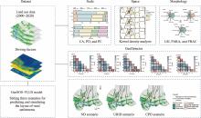
Fig. 1.
Analytical framework of this study. GeoSOS-FLUS, Geographical Simulation and Optimization System-Future Land Use Simulation; CA, core area; PD, patch density; PC, patch count; LSI, landscape shape index; PARA, perimeter area ratio; FRAC, fractal dimension index; ND scenario, natural development scenario; URID scenario, urban-rural integration development scenario; CPD scenario, cropland protection development scenario; X1, digital elevation model (DEM); X2, slope; X3, hydrological accessibility; X4, cropland proximity; X5, transportation convenience; X6, population density. Note that the figures are based on the standard map (GS(2024)0650) from the National Platform for Common Geospatial Information Services (https://cloudcenter.tianditu.gov.cn/) issued by the Ministry of Natural Resources of the People’s Republic of China, and the boundary of the standard map used in this study has not been modified."

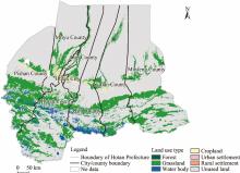
Fig. 2.
Overview of the study area. Note that the figure is based on the standard map (GS(2024)0650) from the National Platform for Common Geospatial Information Services (https://cloudcenter.tianditu.gov.cn/) issued by the Ministry of Natural Resources of the People’s Republic of China, and the boundary of the standard map used in this study has not been modified."
Table 1
Selection of landscape pattern indices."
| Landscape pattern index | Description |
|---|---|
| Core area (CA) | It represents the total area covered by a given landscape patch type. |
| Patch density (PD) | It characterizes the overall landscape heterogeneity and fragmentation. |
| Landscape shape index (LSI) | It quantifies patch complexity by measuring the deviation between the shape of a given patch and a circle or square with an identical area. |
| Perimeter area ratio (PARA) | The higher the morphological complexity of the patches, the greater the PARA value. |
| Fractal dimension index (FRAC) | This index quantifies fractal dimensional complexity and overcomes the limitations of traditional integer dimensions. It can take non-integer values to reflect the irregular morphological features of patches. |
Table 2
Selection of indicators that affect the layout of rural settlements."
| Indicator | Indicator proxy | Impact mechanism | Index property | Reference |
|---|---|---|---|---|
| Digital elevation model (DEM) | X1 | High-altitude regions hinder construction and agricultural activities, restricting settlement distribution. | Negative | Lin and Hou ( Ma et al. ( |
| Slope | X2 | Construction costs rise substantially in steep-slope areas, and such terrain is also unfavourable for agricultural production. | Negative | Ji et al. ( Zhao et al. ( |
| Hydrological accessibility | X3 | Settlements in arid areas are predominantly distributed near water, which constitutes their core pattern. | Positive | Zhang et al. ( Zou et al. ( |
| Cropland proximity | X4 | In Hotan Prefecture, there is a strong spatial correlation between settlements and cropland. | Positive | Chen et al. ( Rao et al. ( |
| Transportation convenience | X5 | Settlements near transportation routes tend to cluster due to superior transport accessibility. | Positive | Zhou et al. ( Ma et al. ( |
| Population density | X6 | Settlements tend to be more concentrated in densely populated areas. | Positive | Huang et al. ( Ma et al. ( |
Table 3
Landscape pattern indices of rural settlements in the study area in 2000, 2010, and 2020."
| Year | Patch count (patches) | PD (units/km2) | Patch area (km2) | Average patch area (km2) | ||||
|---|---|---|---|---|---|---|---|---|
| Level I | Level II | Level III | Level IV | Level V | ||||
| 2000 | 149 | 946 | 416 | 75 | 58 | 7.500 | 399.660 | 0.264 |
| 2010 | 73 | 268 | 215 | 48 | 35 | 3.800 | 197.820 | 0.240 |
| 2020 | 66 | 266 | 219 | 49 | 39 | 3.900 | 208.370 | 0.263 |
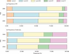
Fig. 3.
Proportions of rural settlements across different size grades in Hotan Prefecture in 2000, 2010 and 2020. (a), proportion of PC by size grade; (b), proportion of total area by size grade. Level I, Level II, Level III, Level IV, and Level V denote different scales of rural settlements; specifically, micro-sized settlements (Level I): <0.05 km2, small-sized settlements (Level II): 0.05-0.20 km2, medium-sized settlements (Level III): 0.20-0.60 km2, large-sized settlements (Level IV): 0.60-1.00 km2, and extra-large-sized settlements (Level V): >1.00 km2."
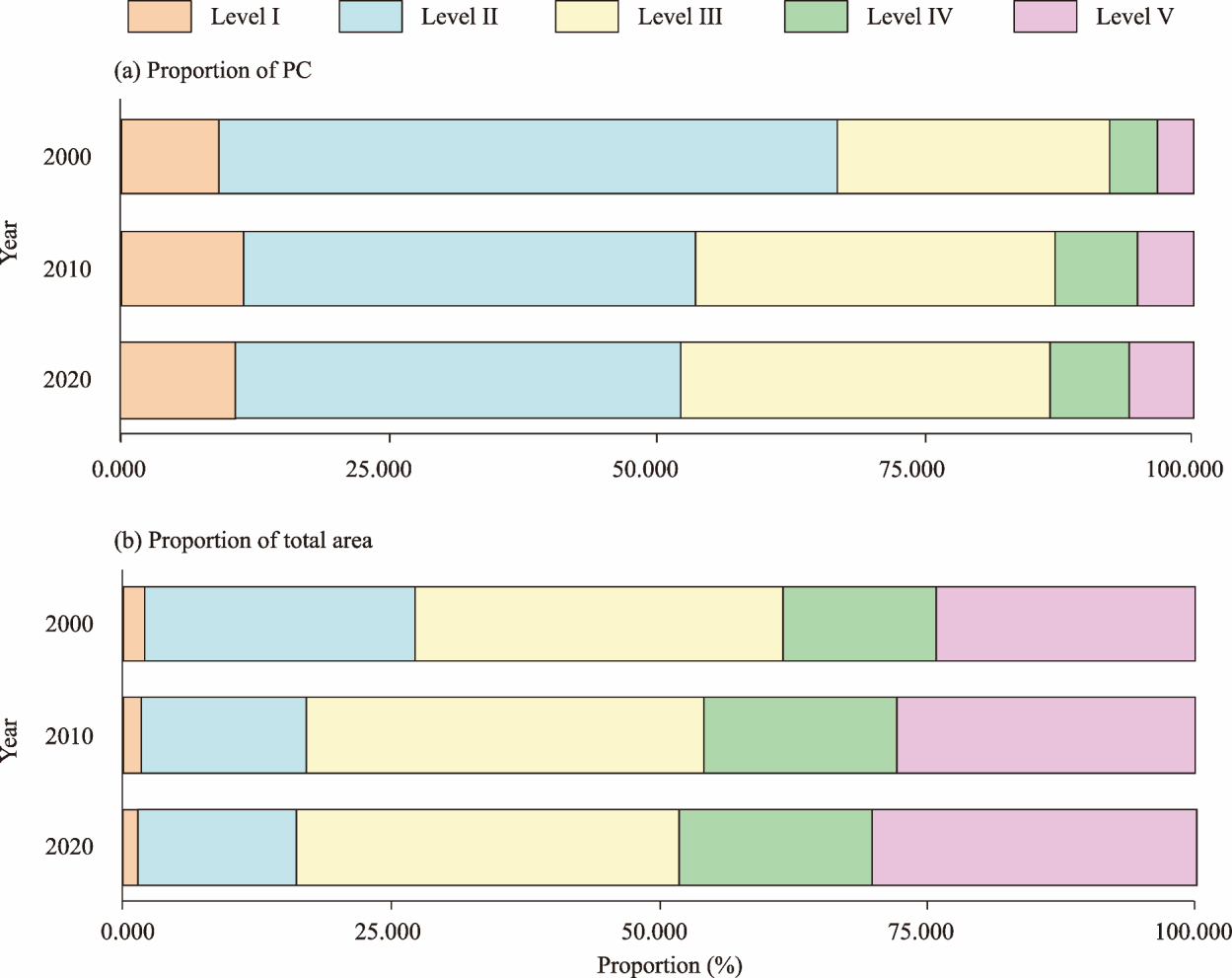
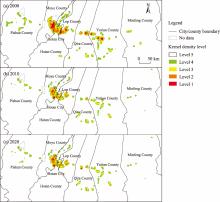
Fig. 4.
Kernel density analysis of rural settlements in Hotan Prefecture in 2000 (a), 2010 (b), and 2020 (c). The kernel density values were classified into five levels, including Level 1 (2.528-3.160 units/km2), Level 2 (1.896-2.528 units/km2), Level 3 (1.264-1.896 units/km2), Level 4 (0.632-1.264 units/km2), and Level 5 (0.000-0.632 units/km2). Note that the figures are based on the standard map (GS(2024)0650) from the National Platform for Common Geospatial Information Services (https://cloudcenter.tianditu.gov.cn/) issued by the Ministry of Natural Resources of the People’s Republic of China, and the boundary of the standard map used in this study has not been modified."

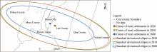
Fig. 5.
Trend of rural settlement evolution in Hotan Prefecture in 2000, 2010, and 2020. Note that the figure is based on the standard map (GS(2024)0650) from the National Platform for Common Geospatial Information Services (https://cloudcenter.tianditu.gov.cn/) issued by the Ministry of Natural Resources of the People’s Republic of China, and the boundary of the standard map used in this study has not been modified."
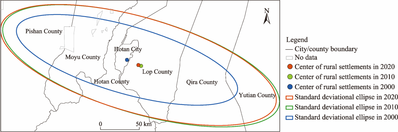
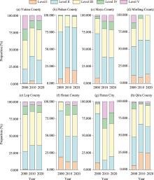
Fig. 6.
Proportions of rural settlements across different size grades in Hotan Prefecture in 2000, 2010, and 2020. (a), Yutian County; (b), Pishan County; (c), Moyu County; (d), Minfeng County; (e), Lop County; (f), Hotan County; (g), Hotan City; (h), Qira County."

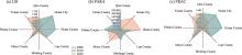
Fig. 7.
Morphological changes of rural settlements in Hotan Prefecture in 2000, 2010, and 2020. (a), LSI; (b), PARA; (c), FRAC."

Table 4
Explanatory power of driving factors for the distribution of rural settlements."
| Landscape pattern index | q-value | |||||
|---|---|---|---|---|---|---|
| X1 | X2 | X3 | X4 | X5 | X6 | |
| CA | 0.143 | 0.127 | 0.438 | 0.373 | 0.187 | 0.115 |
| PD | 0.208 | 0.193 | 0.511 | 0.393 | 0.199 | 0.130 |
| LSI | 0.096 | 0.122 | 0.210 | 0.120 | 0.227 | 0.108 |
| PARA | 0.150 | 0.164 | 0.221 | 0.264 | 0.175 | 0.137 |
| FRAC | 0.128 | 0.135 | 0.113 | 0.158 | 0.127 | 0.094 |
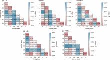
Fig. 8.
Explanatory power of interactive driving factors for landscape pattern indices. (a), CA; (b), PD; (c), FRAC; (d), LSI; (e), PARA."

Table 5
Neighborhood factor weights of different land use types under different scenarios."
| Scenario | Neighborhood factor weight | ||||||
|---|---|---|---|---|---|---|---|
| Cropland | Forest | Grassland | Water body | Urban settlement | Rural settlement | Unused land | |
| ND scenario | 0.5 | 0.3 | 0.5 | 0.5 | 0.8 | 0.5 | 0.1 |
| URID scenario | 0.6 | 0.4 | 0.4 | 0.6 | 0.4 | 0.3 | 0.1 |
| CPD scenario | 0.8 | 0.3 | 0.5 | 0.5 | 0.4 | 0.3 | 0.1 |
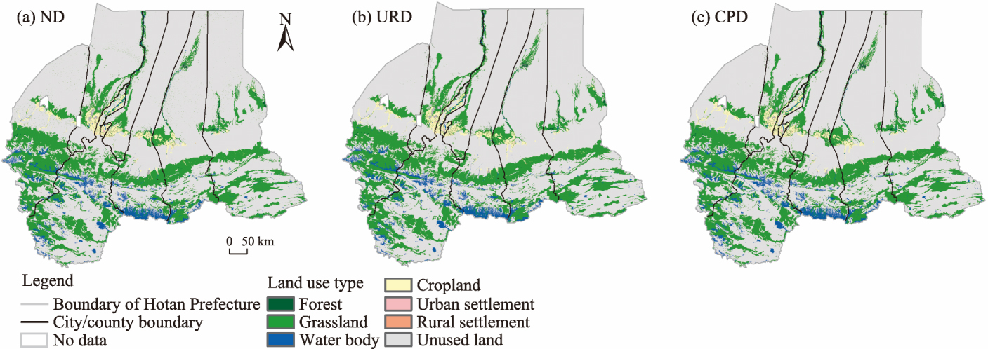
Fig. 9.
Prediction of land use changes in Hotan Prefecture under different scenarios in 2030. (a), ND scenario; (b), URID scenario; (c), CPD scenario. Note that the figures are based on the standard map (GS(2024)0650) from the National Platform for Common Geospatial Information Services (https://cloudcenter.tianditu.gov.cn/) issued by the Ministry of Natural Resources of the People’s Republic of China, and the boundary of the standard map used in this study has not been modified."
| [1] | Aydemir Ç., Örücü S., 2025. Analyzing land use changes with urban atlas data to understand urbanization’s impact on rural settlements in Isparta, Türkiye. Environment, Development and Sustainability. 1-23. |
| [2] | Bureau of Statistics of Xinjiang Uygur Autonomous Region,2002-2022. Xinjiang Statistical Yearbook (2001-2021). Beijing: China Statistics Press (in Chinese). |
| [3] | Cao C.J., Song W., 2022. Discerning spatiotemporal patterns and policy drivers of rural settlement changes from 1962 to 2020. Land. 11(8), 1317, doi: 10.3390/land11081317. |
| [4] | Cao Y., Li G.Y., Cao Y., et al., 2020. Distinct types of restructuring scenarios for rural settlements in a heterogeneous rural landscape: Application of a clustering approach and ecological niche modeling. Habitat International. 104, 102248, doi: 10.1016/j.habitatint.2020.102248. |
| [5] | Cao Y., Li G.D., 2024. Extensive inequality of residential greenspace exposure within urban areas in China. Science of The Total Environment. 948, 174625, doi: 10.1016/j.scitotenv.2024.174625. |
| [6] | Chen W.Q., Liu Y.L., Yin C.H., et al., 2017a. Layout optimization for rural settlements based on iterative evaluation method and its remediation strategies. Transactions of the Chinese Society of Agricultural Engineering. 33(17), 255-263 (in Chinese). |
| [7] | Chen Z.F., Li Y.R., Liu Y.S., 2017b. Distribution pattern characteristic and type classification of rural settlements in loess hilly-gully region. Transactions of the Chinese Society of Agricultural Engineering. 33(14), 266-274 (in Chinese). |
| [8] | Conrad C., Rudloff M., Abdullaev I., et al., 2015. Measuring rural settlement expansion in Uzbekistan using remote sensing to support spatial planning. Applied Geography. 62, 29-43. |
| [9] | Dong Y., Cheng P., Kong X.S., 2022. Spatially explicit restructuring of rural settlements: A dual-scale coupling approach. Journal of Rural Studies. 94, 239-249. |
| [10] |
Feng Y.B., Long H.L., 2020. Progress and prospect of research on spatial reconstruction of rural settlements in mountainous areas of China. Progress in Geography. 39(5), 866-879 (in Chinese).
doi: 10.18306/dlkxjz.2020.05.014 |
| [11] | Geng B., Tian Y.G., Zhang L.H., et al., 2023. Evolution and its driving forces of rural settlements along the roadsides in the northeast of Jianghan Plain, China. Land Use Policy. 129, 106658, doi: 10.1016/j.landusepol.2023.106658. |
| [12] | Gou R., 2025. The spatial form and types of rural settlement landscape in northwest China. Chinese Journal of Agricultural Resources and Regional Planning. 46(5), 151-160 (in Chinese). |
| [13] | Hirschi C., 2010. Strengthening regional cohesion: Collaborative networks and sustainable development in Swiss rural areas. Ecology and Society. 15(4), 16, doi: 10.5751/ES-03714-15041. |
| [14] |
Hong J.Y., Park S., Yang H., 2022. In strongman we trust: The political legacy of the New Village Movement in South Korea. American Journal of Political Science. 67(4), 850-866.
doi: 10.1111/ajps.v67.4 |
| [15] | Hu C.Y., Wu W., Zhou X.X., et al., 2023. Spatiotemporal changes in landscape patterns in karst mountainous regions based on the optimal landscape scale: A case study of Guiyang City in Guizhou Province, China. Ecological Indicators. 150, 110211, doi: 10.1016/j.ecolind.2023.110211. |
| [16] | Huang Z.X., Fu Y.H., Li J., et al., 2022. Consolidation potential of rural residential areas based on village types: Taking Liaocheng City as an example. China Land Science. 36(12), 78-90 (in Chinese). |
| [17] | Jafarpour G.K., Che R.F., Rambat S., 2024. Application of Cellular Automata and Markov Chain model for urban green infrastructure in Kuala Lumpur, Malaysia. Regional Sustainability. 5(4), 100179, doi: 10.1016/j.regsus.2024.100179. |
| [18] | Ji Z.X., Xu Y.Q., Sun M.X., et al., 2022. Spatiotemporal characteristics and dynamic mechanism of rural settlements based on typical transects: a case study of Zhangjiakou City, China. Habitat International. 123, 102545, doi: 10.1016/J.habitatint.2022.102545. |
| [19] | Jia K.Y., Qiao W.F., Chai Y.B., et al., 2020. Spatial distribution characteristics of rural settlements under diversified rural production functions: a case of Taizhou, China. Habitat International. 102, 102201, doi: 10.1016/j.habitatint.2020.102201. |
| [20] | Jin Q.M., Lu Y.Q., 1984. Scope of settlement services and county-level settlement system. Journal of Nanjing Normal University (Social Science Edition). (2), 87-94 (in Chinese). |
| [21] | Kong X.S., Liu D.F., Tian Y.S., et al., 2021. Multi-objective spatial reconstruction of rural settlements considering intervillage social connections. Journal of Rural Studies. 84, 254-264. |
| [22] |
Lapping M.B., Fuller A.M., 1985. Rural development policy in Canada: An interpretation. Community Development Journal. 20(2), 114-119.
doi: 10.1093/cdj/20.2.114 |
| [23] | Li L., Li X.J., Hai B.B., et al., 2020. Evolution of rural settlement in an inland nonmetropolitan region of China at a time of rapid urbanisation: the case of Gongyi. Journal of Rural Studies. 79, 45-56. |
| [24] | Li L.N., Zhang T.Y., Yang Y.Y., 2024. Unveiling nonlinear effects of transport development on rural settlement transitions along the “southern Jiangsu - northern Shaanxi” transect in China. Ecological Indicators. 159, 111712, doi: 10.1016/j.ecolind.2024.111712. |
| [25] | Li Y.H., Westlund H., Liu Y.S., 2019. Why some rural areas decline while some others not: An overview of rural evolution in the world. Journal of Rural Studies. 68, 135-143. |
| [26] |
Li Z., Zhang X.L., Li H.B., et al., 2018. Evolution paths and the driving mechanism of the urban-rural scale system at the county level: Taking three counties of Jiangsu Province as an example. Acta Geographica Sinica. 73(12), 2392-2408 (in Chinese).
doi: 10.11821/dlxb201812009 |
| [27] | Liang F.C., Liu S.Y., Qi X.X., et al., 2019. Spatial evolution process of rural settlement land in coastal areas of southern Fujian in recent 30 years. Transactions of the Chinese Society of Agricultural Engineering. 35(22), 18-26 (in Chinese). |
| [28] | Lin S.J., Hou L.D., 2023. SDGs-oriented evaluation of the sustainability of rural human settlement environment in Zhejiang, China. Heliyon. 9(2), e13492, doi: 10.1016/j.heliyon.2023.e13492. |
| [29] |
Liu B.S., Zhang X.H., Tian J.F., et al., 2023a. Rural sustainable development: A case study of the Zaozhuang Innovation Demonstration Zone in China. Regional Sustainability. 4(4), 390-404.
doi: 10.1016/j.regsus.2023.11.004 |
| [30] | Liu M.H., Xi J.C., 2019. A Multi-agent model for simulation of rural settlement land use pattern: A case study of gouge village of Yesanpo Scenic Area. Tourism Tribune. 34(11), 107-115 (in Chinese). |
| [31] | Liu M.H., Li Q., Yu B., et al., 2024. A novel framework to evaluate urban-rural coordinated development: a case study in Shanxi Province, China. Habitat International. 144, 103013, doi: 10.1016/j.habitatint.2024.103013. |
| [32] | Liu S.C., Xiao W., Ye Y.M., et al., 2023b. Rural residential land expansion and its impacts on cultivated land in China between 1990 and 2020. Land Use Policy. 132, 106816, doi: 10.1016/j.landusepol.2023.106816. |
| [33] | Liu X.P., Liang X., Li X., et al., 2017a. A future land use simulation model (FLUS) for simulating multiple land use scenarios by coupling human and natural effects. Landscape and Urban Planning. 168, 94-116. |
| [34] | Liu Y.S., Yang Y.Y., Li Y.R., et al., 2017b. Conversion from rural settlements and arable land under rapid urbanization in Beijing during 1985-2010. Journal of Rural Studies. 51, 141-150. |
| [35] |
Liu Y.S., 2018. Research on the urban-rural integration and rural revitalization in the new era in China. Acta Geographica Sinica. 73(4), 637-650 (in Chinese).
doi: 10.11821/dlxb201804004 |
| [36] |
Long H.L., Li Y.R., Liu Y.S., 2009. Analysis of evolutive characteristics and their driving mechanism of hollowing villages in China. Acta Geographica Sinica. 64(10), 1203-1213 (in Chinese).
doi: 10.11821/xb200910006 |
| [37] | Long H.L., Tu S.S., Ge D.Z., et al., 2016. The allocation and management of critical resources in rural China under restructuring: Problems and prospects. Journal of Rural Studies. 47, 392-412. |
| [38] |
Long H.L., Chen K.Q., 2021. Urban-rural integrated development and land use transitions: A perspective of land system science. Acta Geographica Sinica. 76(2), 295-309 (in Chinese).
doi: 10.11821/dlxb202102004 |
| [39] | Lou Y.C., Huang L., Li A., et al., 2025. Evolution of the spatial pattern and influencing factors of rural settlements in the Taihu Basin over the past century—a case study of Huzhou City, Zhejiang Province. Research of Soil and Water Conservation. 32(4), 320-331 (in Chinese). |
| [40] | Ma C., Wang H.W., Tan B., et al., 2022a. Characteristics and spatial reconstruction of an urban-rural settlement scale system in a typical oasis in Xinjiang: A case study of the Ugan-Kuqa River Delta Oasis. Acta Geographica Sinica. 77(4), 852-868 (in Chinese). |
| [41] | Ma L.B., Tian Y.Y., Guo X.D., et al., 2018a. Spatial-temporal change of rural settlements and its spatial coupling relationship with water and soil resources based on grid in the Hexi oasis. Journal of Natural Resources. 33(5), 775-787 (in Chinese). |
| [42] | Ma L.B., Liu S.C., Tao T.M., et al., 2022b. Spatial reconstruction of rural settlements based on livability and population flow. Habitat International. 126, 102614, doi: 10.1016/j.habitatint.2022.102614. |
| [43] | Ma L.B., Li J.Y., Wang X., et al., 2024. Evolution and simulation optimization of rural settlements in urban-rural integration areas from a multi-gradient perspective: A case study of the Lan-Bai urban agglomeration in China. Habitat International. 153, 103203, doi: 10.1016/j.habitatint.2024.103203. |
| [44] | Ma L.B., Zhao S.C., Wang X., et al., 2026. Unveiling the dynamics: Tracing rural settlements evolution in urban-rural transition zones. Cities. 171, 106772, doi: 10.1016/j.cities.2026.106772. |
| [45] | Ma M.Y., Tang J.X., 2023. Nonlinear impact and spatial effect of tourism urbanization on human settlement environment: Evidence from the Yellow River Basin, China. Journal of Cleaner Production. 428, 139432, doi: 10.1016/j.jclepro.2023.139432. |
| [46] | Ma W.Q., Jiang G.H., Li W.Q., et al., 2018b. How do population decline, urban sprawl and industrial transformation impact land use change in rural residential areas? A comparative regional analysis at the peri-urban interface. Journal of Cleaner Production. 205, 76-85. |
| [47] |
Ma X.D., Qiu F.D., Li Q.L., et al., 2013. Spatial pattern and regional types of rural settlements in Xuzhou City, Jiangsu Province, China. Chinese Geographical Science. 23(4), 482-491.
doi: 10.1007/s11769-013-0615-8 |
| [48] | National Bureau of Statistics, 2022. China Statistical Yearbook 2021. Beijing: China Statistics Press (in Chinese). |
| [49] | Niyogakiza A., Liu Q.B., 2025. GIS-driven multi-criteria assessment of rural settlement patterns and attributes in Rwanda’s Western Highlands (Central Africa). Sustainability. 17(14), 6406, doi: 10.3390/su17146406. |
| [50] |
Noble V., 2019. Mobilities of the One-Product policy from Japan to Thailand: A critical policy study of OVOP and OTOP. Territory, Politics, Governance. 7(4), 455-473.
doi: 10.1080/21622671.2018.1511463 |
| [51] | Ou C., Liu Y.S., Wang J.Y., et al., 2026. Assessing the hollowing risk of rural settlements in China using a bottom-up and region-adapted framework. Habitat International. 167, 103659, doi: 10.1016/j.habitatint.2025.103659. |
| [52] | Qu Y.B., Jiang G.H., Li Z., et al., 2019. Understanding rural land use transition and regional consolidation implications in China. Land Use Policy. 82, 742-753. |
| [53] | Rao Y.F., Zou Y.F., Yi C.F., et al., 2023. Optimization of rural settlements based on rural revitalization elements and rural residents’ social mobility: A case study of a township in western China. Habitat International. 137, 102851, doi: 10.1016/j.habitatint.2023.102851. |
| [54] |
Ren C.C., Zhou X.Y., Wang C., et al., 2023. Ageing threatens sustainability of smallholder farming in China. Nature. 616(7955), 96-103.
doi: 10.1038/s41586-023-05738-w |
| [55] | Ruzi N., Wang X.M., Liang T., 2024. Study on dynamic change of fractional vegetation cover and its climate response in Hotan Area. Ecological Science. 43(6), 137-146 (in Chinese). |
| [56] | Santoro A., 2024. Why traditional rural landscapes are still important to our future. Landscape Ecology. 39, 135, doi: 10.1007/s10980-024-01940-x. |
| [57] | Shahi D.K., 2022. Morphological and functional change of rural settlements in the High Himalayan Region: A case study of Arakot, Uttarkashi. Research Journal of Humanities and Social Sciences. 13(1), 45-50. |
| [58] | Silva L., Leal J., 2015. Rural tourism and national identity building in contemporary Europe: Evidence from Portugal. Journal of Rural Studies. 38, 109-119. |
| [59] | Tellman B., Jain M., Eakin H., et al., 2026. Electoral politics influence expansion and titling of informal urban settlements. Proceedings of the National Academy of Sciences of the United States of America. 123(21), e2421303123, doi: 10.1073/pnas.2421303123. |
| [60] | Tian X.R., Yu Z.X., Wang J., et al., 2025. Tourism-driven spatial restructuring of urban and rural settlements in the Lijiang Intermontane Basin, China. Remote Sensing Applications: Society and Environment. 40, 101748, doi: 10.1016/j.rsase.2025.101748. |
| [61] | Tomasz F., Łukasz M., 2020. Analysis of morphological changes of rural settlement patterns after World War II in the metropolitan area of Łódź using a graph theory based method. Environmental & Socio-economic Studies. 8(4), 57-72. |
| [62] | Van Vliet J., 2019. Direct and indirect loss of natural area from urban expansion. Nature Sustainability. 2, 755-763. |
| [63] | Wang H., Zhao H., Wang F.Q., et al., 2024. Study on the multi-type drought propagation process and driving factors on the Tibetan Plateau. Journal of Hydrology. 645(Part A), 132162, doi: 10.1016/j.jhydrol.2024.132162. |
| [64] | Wang J.L., Liu B., Zhou T., 2023. The category identification and transformation mechanism of rural regional function based on SOFM model: a case study of Central Plains Urban Agglomeration, China. Ecological Indicators. 147, 109926, doi: 10.1016/j.ecolind.2023.109926. |
| [65] | Wang J.Y., Wang X.Y., Du G.M., et al., 2022. Temporal and spatial changes of rural settlements and their influencing factors in northeast China from 2000 to 2020. Land. 11(10), 1640, doi: 10.3390/land11101640. |
| [66] | Wang L.C., Gao J., 2014. Research on the spatial coupling relationship between agglomeration and soil and water resources based on the scale of irrigation district—Taking Zhangye oasis as an example. Journal of Natural Resources. 29(11), 1888-1901 (in Chinese). |
| [67] | Wang Q.A., 2007. New town construction and development of United States in post-war and its suggestion. Urban Planning International. 22(1), 63-66 (in Chinese). |
| [68] |
Wang Y., Bi G.H., Yang Q.Y., et al., 2016. Analyzing land use characteristics of rural settlements on the urban fringe of Liangjiang New Area, Chongqing, China. Journal of Mountain Science. 13(10), 1855-1866.
doi: 10.1007/s11629-016-3851-4 |
| [69] | Wang Z.L., Wang C., Dou H.J., et al., 2025. A strategy of building a beautiful and harmonious countryside: reuse of idle rural residential land based on symbiosis theory. Habitat International. 155, 103238, doi: 10.1016/j.habitatint.2024.103238. |
| [70] | Xu B.B., Zhang X., Zhang J.J., et al., 2025a. Reciprocal regulation between rural settlement expansion and human-elephant conflict in China’s wild elephant range. Geography and Sustainability. 6(2), 100238, doi: 10.1016/j.geosus.2024.08.014. |
| [71] | Xu Y.S., Tang Y.X., Zhao Z.Q., 2025b. Research on the spatial characteristics of the cultural landscape in rural station settlements along the Chinese eastern railway. Landscape Architecture Academic Journal. 42(8), 23-33 (in Chinese). |
| [72] | Yang L., Tian G.J., Li L., et al., 2023. The transition characteristics and driving mechanisms of rural residential land in metropolitan areas—a case study of Tianjin, China. Environmental Science and Pollution Research. 30, 54130-54148. |
| [73] | Yang L.P., Ou C., Wang Z., et al., 2025. Unveiling patterns and drivers of long-term rural settlement changes from the urban-rural gradient perspective: A case study of the Beijing-Tianjin-Hebei region in China. Habitat International. 156, 103300, doi: 10.1016/j.habitatint.2025.103300. |
| [74] | Yin J.B., Wang D.Y., Li H., 2023. Spatial optimization of rural settlements in ecologically fragile regions: Insights from a social-ecological system. Habitat International. 138, 102854, doi: 10.1016/j.habitatint.2023.102854. |
| [75] | Zhang B.L., Zhang F.R., Gao Y., et al., 2014. Identification and spatial differentiation of rural settlements’ multifunction. Transactions of the Chinese Society of Agricultural Engineering. 30(12), 216-224 (in Chinese). |
| [76] | Zhang W.B., Ma L.B., Li H.B., et al., 2024. Trends in the future evolution of rural settlements in oasis-desert areas under water use simulation scenarios: Take the Hexi Corridor region of China as an example. Landscape and Urban Planning. 248, 105110, doi: 10.1016/j.landurbplan.2024.105110. |
| [77] | Zhang Y., Zhang L.Q., Wang J.Y., et al., 2023. Quantitative analysis of NDVI driving factors based on the geographical detector model in the Chengdu-Chongqing region, China. Ecological Indicators. 155, 110978, doi: 10.1016/j.ecolind.2023.110978. |
| [78] | Zhao Z.J., Fan B.L., Du X.W., et al., 2024. Spatial expansion characteristics of rural settlements and its response to determinants in Hangzhou Bay Urban Agglomeration, China: Geospatial modeling using multiscale geographically weighted regression (MGWR). Journal of Cleaner Production. 484, 144339, doi: 10.1016/j.jclepro.2024.144339. |
| [79] | Zhou J.Z., Hou Q.H., 2021. Resilience assessment and planning of suburban rural settlements based on complex network. Sustainable Production and Consumption. 28, 1645-1662. |
| [80] | Zhou X.P., Guo Y.J., Zhang H., et al., 2021. Multifunctional evaluation and governance strategies of rural surrounding cities: A case study of Yinzhou district and Chiping district. Urban Development Studies. 28(11), 110-117 (in Chinese). |
| [81] | Zhou Y., Zhong Z., Cheng G.Q., 2023. Cultivated land loss and construction land expansion in China: evidence from national land surveys in 1996, 2009 and 2019. Land Use Policy. 125, 106496, doi: 10.1016/j.landusepol.2022.106496. |
| [82] | Zou Y.F., Rao Y.F., Luo F., et al., 2024. Evolution of rural settlements and its influencing mechanism in the farming-pastoral ecotone of Inner Mongolia from a production-living-ecology perspective. Habitat International. 151, 103137, doi: 10.1016/j.habitatint.2024.103137. |
| [83] |
Zubarevich V.N., 2013. Transformation of the rural settlement pattern and social services network in rural areas. Regional Research of Russia. 3(3), 221-233.
doi: 10.1134/S2079970513030118 |
| [1] | SUN Lingxiao, LI Chunlan, YU Yang, HE Jing, YANG Meilin, WANG Qian, LIANG Xueqiong, Ireneusz MALIK, Małgorzata WISTUBA. Quantifying desertification control efficiency in a hyper-arid region: Spatiotemporal dynamics and policy synergies in Hotan Prefecture of China during 2005-2023 [J]. Regional Sustainability, 2025, 6(6): 100275-. |
| [2] | JI Xiaomei, NIE Zhilei, WANG Kaiyong, XU Mingxian, FANG Yuhao. Spatiotemporal evolution and influencing factors of urban resilience in the Yellow River Basin, China [J]. Regional Sustainability, 2024, 5(3): 100159-. |
| Viewed | ||||||
|
Full text |
|
|||||
|
Abstract |
|
|||||
 REGSUS Wechat
 新公网安备 65010402001202号