Regional Sustainability ›› 2024, Vol. 5 ›› Issue (1): 100111.doi: 10.1016/j.regsus.2024.03.005cstr: 32279.14.j.regsus.2024.03.005
• Full Length Article • Previous Articles Next Articles
Walid CHOUARIa,b,*( )
)
Received:2023-03-18
Accepted:2024-02-28
Published:2024-03-30
Online:2024-04-30
Contact:
E-mail address: Walid CHOUARI. Assessment of vegetation cover changes and the contributing factors in the Al-Ahsa Oasis using Normalized Difference Vegetation Index (NDVI)[J]. Regional Sustainability, 2024, 5(1): 100111.
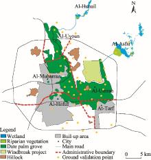
Fig. 1.
Overview of the Al-Ahsa Oasis."
Table 1
Built-up area in the Al-Ahsa Oasis during 1972-2021."
| Year | Area (km2) | Percentage of increased area (%) |
|---|---|---|
| 1972 | 7.13 | |
| 1987 | 50.46 | 707.71 |
| 2002 | 85.86 | 170.15 |
| 2021 | 232.79 | 271.13 |
Table 2
Information of acquired Landsat satellite images."
| Satellite | Sensor | Date of acquisition | Path/Row | Spatial resolution (m) | Data source |
|---|---|---|---|---|---|
| Landsat-5 | Thematic Mapper (TM) | 7 July 1987 | 164/042 | 30 | United States Geological Survey ( |
| Landsat-7 | TM | 16 July 2002 | 164/042 | 30 | |
| Landsat-8 | Operational Land Imager (OLI) | 20 July 2021 | 164/042 | 30 |
Fig. 2.
Spatial distributions of Normalized Difference Vegetation Index (NDVI) in the Al-Ahsa Oasis in 1987 (a), 2002 (b), and 2021 (c)."
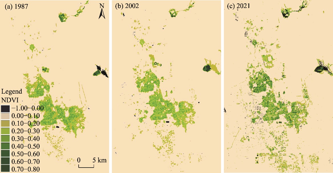
Table 3
Area and percentage of Normalized Difference Vegetation Index (NDVI) classes in the Al-Ahsa Oasis."
| NDVI class | 1987 | 2002 | 2021 | |||
|---|---|---|---|---|---|---|
| Area (km2) | Percentage (%) | Area (km2) | Percentage (%) | Area (km2) | Percentage (%) | |
| −1.00-0.00 | 5.13 | 0.19 | 8.03 | 0.30 | 1.31 | 0.05 |
| 0.00-0.10 | 2493.90 | 93.27 | 2300.99 | 86.05 | 808.68 | 30.25 |
| 0.10-0.20 | 69.79 | 2.61 | 75.16 | 2.81 | 1691.12 | 63.25 |
| 0.20-0.30 | 51.21 | 1.92 | 57.29 | 2.14 | 76.39 | 2.86 |
| 0.30-0.40 | 47.17 | 1.76 | 41.41 | 1.55 | 52.25 | 1.95 |
| 0.40-0.50 | 5.59 | 0.21 | 3.83 | 0.15 | 9.68 | 0.36 |
| 0.50-0.60 | 1.12 | 0.04 | 93.60 | 3.50 | 2.98 | 0.11 |
| 0.60-0.70 | 0.00 | 0.00 | 93.60 | 3.50 | 30.60 | 1.14 |
| 0.70-0.80 | 0.00 | 0.00 | 0.00 | 0.00 | 0.90 | 0.03 |
| Total | 2673.91 | 100.00 | 2673.91 | 100.00 | 2673.91 | 100.00 |
Fig. 3.
Spatiotemporal variation of mean NDVI in the Al-Ahsa Oasis in 1987-2002 (a) and 2002-2021 (b)."
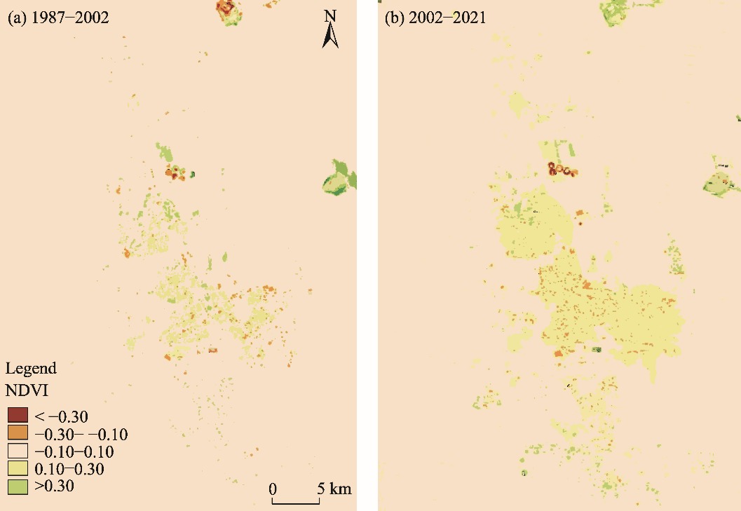
Table 4
Changes of NDVI classes in the Al-Ahsa Oasis in 1987-2002 and 2002-2021."
| NDVI class | 1987-2002 | 2002-2021 | ||
|---|---|---|---|---|
| Area (km2) | Percentage (%) | Area (km2) | Percentage (%) | |
| < -0.30 | 1.49 | 0.06 | 1.10 | 0.04 |
| -0.30- -0.10 | 18.67 | 0.70 | 17.06 | 0.64 |
| -0.10-0.10 | 2624.04 | 98.13 | 2631.78 | 98.42 |
| 0.10-0.30 | 27.45 | 1.03 | 22.93 | 0.86 |
| >0.30 | 2.26 | 0.08 | 1.04 | 0.04 |
Table 5
Vegetation cover area and percentage of increased vegetation cover area in the Al-Ahsa Oasis in 1972-2021."
| Year | Area (km2) | Percentage of increased vegetation cover area (%) |
|---|---|---|
| 1972 | 119.70 | |
| 1987 | 131.60 | 9.90 |
| 2002 | 135.10 | 2.70 |
| 2021 | 154.20 | 14.10 |
Table 6
Evaluation of the accuracy of satellite image processing in the Al-Ahsa Oasis in 1987, 2002, and 2021."
| NDVI class | Producer’s accuracy (%) | User’s accuracy (%) | ||||
|---|---|---|---|---|---|---|
| 1987 | 2002 | 2021 | 1987 | 2002 | 2021 | |
| < -0.30 | 90.10 | 91.40 | 92.50 | 88.90 | 90.10 | 92.70 |
| -0.30- -0.10 | 90.30 | 91.80 | 92.90 | 88.90 | 90.30 | 92.90 |
| -0.10-0.10 | 92.10 | 92.70 | 93.90 | 89.60 | 91.20 | 93.00 |
| 0.10-0.30 | 92.60 | 93.10 | 94.70 | 90.10 | 92.30 | 93.70 |
| [1] | Abdelatti, H., Elhadary, Y., Babiker, A.A., 2017. Nature and trend of urban growth in Saudi Arabia: The case of Al-Ahsa Province-eastern region. Resources and Environment. 7(3), 69-80. |
| [2] |
Abderrahman, W., 1988. Water management plan for the Al-Hassa irrigation and drainage project in Saudi Arabia. Agric. Water Manage. 13(2-4), 185-194.
doi: 10.1016/0378-3774(88)90153-9 |
| [3] | Abolkhair, Y., 1981. Sand encroachment by wind in Al-Hasa of Saudi Arabia. PhD Dissertation. Bloomington: Indiana University, 415. |
| [4] | Adams, J.B., Gillespie, A.R., 2006. Remote Sensing of Landscapes with Spectral Images:A Physical Modeling Approach. Cambridge: Cambridge University Press, 362. |
| [5] |
Allbed, A., Kumar, L., Sinha, P., 2017. Soil salinity and vegetation cover change detection from multi-temporal remotely sensed imagery in Al Hassa Oasis in Saudi Arabia. Geocarto Int. 33(8), 830-846.
doi: 10.1080/10106049.2017.1303090 |
| [6] | Almadini, A.M., Hassaballa, A.A., 2019. Depicting changes in land surface cover at Al-Hassa oasis of Saudi Arabia using remote sensing and GIS techniques. PLoS One. 14(11), e0221115, doi: 10.1371/journal.pone.0221115. |
| [7] | Alqurashi, A.F., Kumar, L., 2014. Land use and land cover change detection in the Saudi Arabian desert cities of Makkah and Al-Taif using Satellite Data. Advances in Remote Sensing. 3, 106-119. |
| [8] | Alqurashi, A.F., Kumar, L., Sinha, P., 2016. Urban land cover change modelling using time-series satellite images: A case study of urban growth in five cities of Saudi Arabia. Remote Sens. 8, 838, doi: 10.3390/rs8100838. |
| [9] |
Alqurashi, A.F., Kumar, L., 2019. An assessment of the impact of urbanization and land use changes in the fast-growing cities of Saudi Arabia. Geocarto Int. 34(1), 78-97.
doi: 10.1080/10106049.2017.1367423 |
| [10] |
Biro Turk, K.H., Aljughaiman, A.S., 2020. Land use/land cover assessment as related to soil and irrigation water salinity over an oasis in arid environment. Open Geosci. 12(1), 220-231.
doi: 10.1515/geo-2020-0103 |
| [11] |
Bruzzone, L., Prieto, D.F., 2000. Automatic analysis of the difference image for unsupervised change detection. IEEE Trans. Geosci. Remote Sensing. 38(3), 1171-1182.
doi: 10.1109/36.843009 |
| [12] |
Chen, J., Gong, P., He, C.Y., et al., 2003. Land-use/land-cover change detection using improved change-vector analysis. Photogramm. Eng. Remote Sens. 69(4), 369-379.
doi: 10.14358/PERS.69.4.369 |
| [13] | Chouari, W., 2021. Wetland land cover change detection using multitemporal Landsat data: A case study of the Al-Asfar wetland, Kingdom of Saudi Arabia. Arab. J. Geosci. 14(6), 523, doi: 10.1007/s12517-021-06815-y. |
| [14] | Chouari, W., 2023. Spatiotemporal analysis of land cover changes in Al-Hubail Wetland (Kingdom of Saudi Arabia). J. Indian Soc. Remote Sens. 5(1), 585-599. |
| [15] | Coppin, P., Jonckheere, I., Nackaerts, K., et al., 2004. Digital change detection methods in ecosystem monitoring: A review. Int. J. Remote Sens. 25, 1565-1596. |
| [16] |
Foody, G.M., 2003. Remote sensing of tropical forest environments: Towards the monitoring of environmental resources for sustainable development, Int. J. Remote Sens. 24(20), 4035-4046.
doi: 10.1080/0143116031000103853 |
| [17] | Foody, G.M., 2007. Editorial: Ecological applications of remote sensing and GIS. Ecol. Inform. 2, 71-72. |
| [18] | Gandhi, G.M., Parthiban, S., Thummalu, N., et al., 2015. NDVI: Vegetation change detection using remote sensing and GIS-a case study of Vellore District. Procedia Computer Science. 57, 1199-1210. |
| [19] | Girardin, P., Bockstaller, C., van der Werf, H., 2000. Assessment of potential impacts of agricultural practices on the environment: the AGRO*ECO method. Environ. Impact Assess. Rev. 20(2), 227-239. |
| [20] | Giri, C.P., 2012. Remote Sensing of Land Use and Land Cover:Principles and Applications Remote Sensing Applications Series. Boca Raton: CRC Press, 477. |
| [21] | Hayes, D.J., Sader, S.A., 2001. Comparison of change-detection techniques for monitoring tropical forest clearing and vegetation regrowth in a time series. Photogrammetric Eng. Remote Sens. 67(9), 1067-1075. |
| [22] | Hua, W.J., Chen, H.S., Zhou, L.M., et al., 2017. Observational quantification of climatic and human influences on vegetation greening in China. Remote Sens. 9(5), 425, doi: 10.3390/rs9050425. |
| [23] | Jensen, J.R., 1996. Introductory Digital Image Processing: A Remote Sensing Perspective (2nd edition). New Jersey: Prentice Hall, 526. |
| [24] | Jiang, L.G., Liu, Y., Wu, S., et al., 2021. Analyzing ecological environment change and associated driving factors in China based on NDVI time series data. Ecol. Indic. 129, 107933, doi: 10.1016/j.ecolind.2021.107933. |
| [25] | Ju, J., Roy, D.P., 2008. The availability of cloud-free Landsat ETM+ data over the conterminous United States and globally. Remote Sens. Environ. 112(3), 1196-1211. |
| [26] | Kleynhans, W., Olivier, J.C., Wessels, K.J., et al., 2011. Detecting land cover change using an extended Kalman Filter on MODIS NDVI time-series data. IEEE Geosci. Remote Sens. Lett. 8(3), 507-511. |
| [27] |
Mancino, G., Nolè, A., Ripullone, F., et al., 2014. Landsat TM imagery and NDVI differencing to detect vegetation change: Assessing natural forest expansion in Basilicata, southern Italy. iForest. 7(2), 75-84.
doi: 10.3832/ifor0909-007 |
| [28] | Martinez, B., Gilabert, M.A., 2009. Vegetation dynamics from NDVI time series analysis using the wavelet transform. Remote Sens. Environ. 113(9), 1823-1842. |
| [29] |
Mas, J.F., 1999. Monitoring land-cover changes: A comparison of change detection techniques. Int. J. Remote Sens. 20(1), 139-152.
doi: 10.1080/014311699213659 |
| [30] |
Mueller, T., Dressler, G., Tucker, C.J., et al., 2014. Human land-use practices lead to global long-term increases in photosynthetic capacity. Remote Sens. 6(6), 5717-5731.
doi: 10.3390/rs6065717 |
| [31] |
Patel, N., Kaushal, B., 2010. Improvement of user’s accuracy through classification of principal component images and stacked temporal images. Geo-Spat. Inf. Sci. 13(4), 243-248.
doi: 10.1007/s11806-010-0380-0 |
| [32] | Peters, A.J., Walter-Shea, E.A., Ji, L., et al., 2002. Drought monitoring with NDVI-based standardized vegetation index. Photogramm. Eng. Remote Sens. 68(1), 71-75. |
| [33] |
Podeh, S.S., Oladi, J., Pormajidian, M.R., et al., 2009. Forest change detection in the north of Iran using TM/ETM+ imagery. Asian Journal of Applied Sciences. 2(6), 464-474.
doi: 10.3923/ajaps.2009.464.474 |
| [34] | Pribadi, D.O., Pauleit, S., 2015. The dynamics of peri-urban agriculture during rapid urbanization of Jabodetabek Metropolitan Area. Land Use Pol. 48, 13-24. |
| [35] | Saleh, M.B., Jaya, I.N., Santi, N.A., et al., 2019. Algorithm for detecting deforestation and forest degradation using vegetation indices. Telecommunication Computing Electronics and Control. 17(5), 2335-2345. |
| [36] | Salih, A., 2018. Classification and mapping of land cover types and attributes in Al-Ahsaa Oasis, Eastern Region, Saudi Arabia Using Landsat-7 Data. Journal of Remote Sensing & GIS. 7(1), 228-234. |
| [37] | Sinha, P., Kumar, L., 2012. Binary images in seasonal land-cover change identification: A comparative study in parts of New South Wales, Australia. Int. J. Remote Sens. 34(6), 2162-2186. |
| [38] | Sun, J.Y., Wang, X.H., Chen, A.P., et al., 2011. NDVI indicated characteristics of vegetation cover change in China’s metropolises over the last three decades. Environ. Monit. Assess. 179, 1-14. |
| [39] |
Tucker, C.J., 1979. Red and photographic infrared linear combinations for monitoring vegetation. Remote Sens Environ. 8(2), 127-150.
doi: 10.1016/0034-4257(79)90013-0 |
| [40] | Viana, C.M., Girão, I., Rocha, J., 2019. Long-term satellite image time-series for land use/land cover change detection using refined open source data in a rural region. Remote Sens. 11(9), 1104, doi: 10.3390/rs11091104. |
| [41] | Wang, F.Y., Xu, Y.J., 2010. Comparison of remote sensing change detection techniques for assessing hurricane damage to forests. Environ. Monit. Assess. 162, 311-326. |
| [42] | Woodcock, C.E., Allen, E., Anderson, M., et al., 2008. Free access to Landsat imagery. Science. 320(5879), doi: 10.1126/science.320.5879.1011a. |
| [43] | Xu, X.L., 2018. Spatial Distribution Data Set of China Annual Vegetation Index (NDVI). Data Center for Resources and Environmental Sciences of Chinese Academy of Sciences. [2023-01-15]. https://doi:10.12078/2018060601. |
| [44] | Yi, L., Chen, J.S., Jin, Z.F., et al., 2018. Impacts of human activities on coastal ecological environment during the rapid urbanization process in Shenzhen, China. Ocean Coastal Manage. 154, 121-132. |
| [45] | Zhang, D.J., Jia, Q.Q., Xu, X., et al., 2018. Contribution of ecological policies to vegetation restoration: A case study from Wuqi County in Shaanxi Province, China. Land Use Pol. 73, 400-411. |
| [46] | Zhu, Z., Woodcock, C.E., Olofsson, P., 2012. Continuous monitoring of forest disturbance using all available Landsat imagery. Remote Sens. Environ. 122, 75-91. |
| [1] | SONG Boyi, ZHANG Shihang, LU Yongxing, GUO Hao, GUO Xing, WANG Mingming, ZHANG Yuanming, ZHOU Xiaobing, ZHUANG Weiwei. Characteristics and drivers of the soil multifunctionality under different land use and land cover types in the drylands of China [J]. Regional Sustainability, 2024, 5(3): 100162-. |
| [2] | ZHU Xinyi, GAO Jinlong. Characteristics and influencing mechanisms of production-living- ecological space dynamics in the Three Gorges Reservoir Area (TGRA), Chongqing, China [J]. Regional Sustainability, 2024, 5(2): 100139-. |
| [3] | Johnson Adedeji OLUSOLA, Adeyinka Oluyemi ATURAMU, Olufunke ASAOLU, Olusesan Sola OGUNLEYE. Spatial distribution and potential ecological and health risks associated with heavy metals in the Ijero-Ekiti mining site, Nigeria [J]. Regional Sustainability, 2024, 5(1): 100110-. |
| [4] | Dervis KIRIKKALELI, Emrah SOFUOĞLU, Kashif Raza ABBASI, Kwaku ADDAI. Economic complexity and environmental sustainability in eastern European economies: Evidence from novel Fourier approach [J]. Regional Sustainability, 2023, 4(4): 349-358. |
| [5] | LIU Binsheng, ZHANG Xiaohui, TIAN Junfeng, CAO Ruimin, SUN Xinzhang, XUE Bin. Rural sustainable development: A case study of the Zaozhuang Innovation Demonstration Zone in China [J]. Regional Sustainability, 2023, 4(4): 390-404. |
| [6] | Surendra Singh JATAV, Kalu NAIK. Measuring the agricultural sustainability of India: An application of Pressure-State-Response (PSR) model [J]. Regional Sustainability, 2023, 4(3): 218-234. |
| [7] | Fabiana MANSERVISI, Michele BANZI, Tomaso TONELLI, Paolo VERONESI, Susanna RICCI, Damiano DISTANTE, Stefano FARALLI, Giuseppe BORTONE. Environmental complaint insights through text mining based on the driver, pressure, state, impact, and response (DPSIR) framework: Evidence from an Italian environmental agency [J]. Regional Sustainability, 2023, 4(3): 261-281. |
| [8] | Sadat Daaki SSEKIBAALA, Twaha Ahmed KASULE. Examination of the poverty-environmental degradation nexus in Sub-Saharan Africa [J]. Regional Sustainability, 2023, 4(3): 296-308. |
| [9] | Kalamkas NURALINA, Raissa BAIZHOLOVA, Natalya ALEKSANDROVA, Viktor KONSTANTINOV, Alexander BIRYUKOV. Socio-economic development of countries based on the Composite Country Development Index (CCDI) [J]. Regional Sustainability, 2023, 4(2): 115-128. |
| [10] | Subrata HALDAR, Somnath MANDAL, Subhasis BHATTACHARYA, Suman PAUL. Dynamicity of Land Use/Land Cover (LULC): An analysis from peri-urban and rural neighbourhoods of Durgapur Municipal Corporation (DMC) in India [J]. Regional Sustainability, 2023, 4(2): 150-172. |
| [11] | Kwaku ADDAI, Berna SERENER, Dervis KIRIKKALELI. Can environmental sustainability be decoupled from economic growth? Empirical evidence from Eastern Europe using the common correlated effect mean group test [J]. Regional Sustainability, 2023, 4(1): 68-80. |
| [12] | WANG Jiguang, HU Yushang, WU Yucai. Optimal decision-making considering inter-supply-chain competition and negative-spillover from environmental effort [J]. Regional Sustainability, 2022, 3(4): 319-334. |
| [13] | Enoch YELELIERE, Thomas YEBOAH, Philip ANTWI-AGYEI, Prince PEPRAH. Traditional agroecological knowledge and practices: The drivers and opportunities for adaptation actions in the northern region of Ghana [J]. Regional Sustainability, 2022, 3(4): 294-308. |
| [14] | James NJUMWA, Ernest SAINA, Alfred SEREM. Nexus between selected macroeconomic variables and carbon emission in Kenya [J]. Regional Sustainability, 2022, 3(3): 233-243. |
| [15] | MA Chen, WANG Hongwei, XIE Ling, YI Suyan, TAN Bo. Regional characteristics and spatiotemporal differentiation of the prevalence of hand, foot, and mouth disease in Xinjiang, China [J]. Regional Sustainability, 2022, 3(3): 208-222. |
| Viewed | ||||||
|
Full text |
|
|||||
|
Abstract |
|
|||||
 REGSUS Wechat
 新公网安备 65010402001202号