
Regional Sustainability ›› 2026, Vol. 7 ›› Issue (4): 100370.doi: 10.1016/j.regsus.2026.100370
• Research article • Previous Articles Next Articles
Md Rejaul ISLAMa, Mohd RIHANa, Intejar ANSARIa, SHAHFAHAD b, Mohd Waseem NAIKOOc, Swapan TALUKDARd, Atiqur RAHMANa,*( )
)
Received:2025-01-19
Revised:2026-01-20
Accepted:2026-07-15
Published:2026-08-30
Online:2026-08-05
Contact:
*E-mail address: arahman2@jmi.ac.in (Atiqur RAHMAN).
Md Rejaul ISLAM, Mohd RIHAN, Intejar ANSARI, SHAHFAHAD , Mohd Waseem NAIKOO, Swapan TALUKDAR, Atiqur RAHMAN. Evaluating runoff retention and associated flood mitigation services of urban blue-green infrastructure in a mega urban centre[J]. Regional Sustainability, 2026, 7(4): 100370.
Table 1
Blue-green infrastructure (BGI) selected in this study."
| No. | BGI | Location | Area (km2) | Characteristics of BGI |
|---|---|---|---|---|
| 1 | Maidan | 22°33′N, 88°20′E | 1.61 | Tree-covered lands and grasslands |
| 2 | Fort William | 22°33′N, 88°19′E | 1.14 | Tree-covered lands and grasslands |
| 3 | Bidhan Park | 22°34′N, 88°23′E | 0.26 | Water body and tree-covered lands |
| 4 | Subhas Sarobar | 22°33′N, 88°24′E | 0.30 | Water body |
| 5 | Royal Calcutta Golf Club | 22°29′N, 88°21′E | 0.75 | Tree-covered lands and grasslands |
| 6 | Rabindra Sarovar | 22°30′N, 88°21′E | 0.88 | Water body and tree-covered lands |
| 7 | Tollygunge Golf Club | 22°29′N, 88°20′E | 0.52 | Tree-covered lands and grasslands |
| 8 | Nature Park | 22°31′N, 88°17′E | 0.50 | Water body and tree-covered lands |
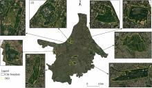
Fig. 1.
Location of the selected blue-green infrastructure (BGI) sites in Kolkata City. (1), Maidan; (2), Fort William; (3), Bidhan Park; (4), Subhas Sarobar; (5), Royal Calcutta Golf Club; (6), Rabindra Sarovar; (7), Tollygunge Golf Club; (8), Nature Park. Note that the administrative boundary was obtained from the Kolkata Municipal Corporation, the base map was sourced from Environmental Systems Research Institute, and the BGI sampling locations were mapped by the authors."

Table 2
Details of datasets, sources, and retrieved information."
| Data type | Spatial resolution | Source | Purpose |
|---|---|---|---|
| Elevation data in the form of a DEM | 30.0 m | USGS Earth Explorer portal | Elevation and watershed delineation and channel identification |
| LULC data | 10.0 m | ESRI | Identification of LULC types |
| Daily rainfall data | 0.5° | NASA POWER | Rainfall trends and DDF curve |
| Hydrologic soil group data | 250.0 m | Global Hydrologic Soil Groups (HYSOGs250m) | Soil properties including texture and organic matter |
| BGI sites | 0.5 m | Google Earth | Delineation of BGI boundaries |
| Flood extent data | 20.0 m | Sentinel-1 SAR | Validation of the UFRM model outcome |
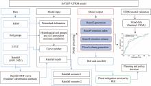
Fig. 2.
Detailed methodological framework of this study. InVEST, Integrated Valuation of Ecosystem Services and Trade-offs; UFRM, Urban Flood Risk Mitigation; DEM, digital elevation model; LULC, land use and land cover; DDF, depth-duration-frequency; SAR, Synthetic Aperture Radar; RF, Random Forest; XGBoost, eXtreme Gradient Boosting; rainfall scenario 1, the runoff during a rainfall event with an intensity of 32.93 mm over a 2-h duration for a 2-a return period; rainfall scenario 2, the runoff during a rainfall event with an intensity of 45.36 mm over a 2-h duration for a 10-a return period."
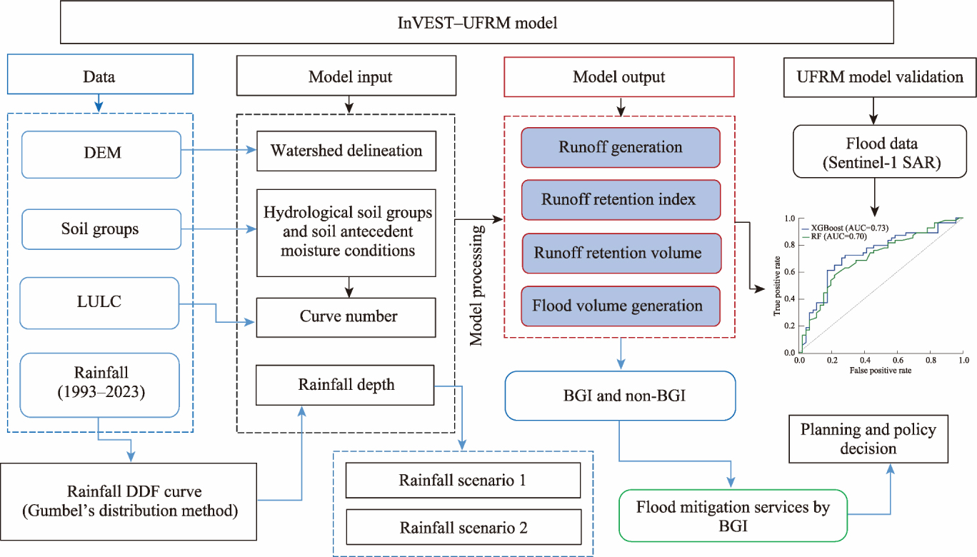
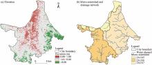
Fig. 3.
Elevation (a) and micro-watersheds and drainage network (b) in Kolkata."

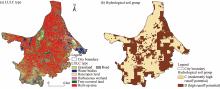
Fig. 4.
Land use and land cover (LULC) types (a) and hydrological soil groups (b) in Kolkata."

Table 3
Details of hydrological soil groups in the study area."
| Soil texture code | Hydrological soil group | Description | Area (km2) | Area percentage (%) | Resampled hydrological soil group |
|---|---|---|---|---|---|
| 3 | C | Moderately high runoff potential (<50.00% sand and 20.00%-40.00% clay) | 107.23 | 53.68 | C |
| 4 | D | High runoff potential (<50.00% sand and >40.00% clay) | 31.38 | 15.71 | D |
| 13 | C/D | Moderately high runoff potential, poorly drained (<50.00% sand and 20.00%-40.00% clay) | 48.90 | 24.48 | D |
| 14 | D/D | High runoff potential, poorly drained (<50.00% sand and >40.00% clay) | 12.25 | 6.13 | D |
Table 4
Curve number (CN) values for different LULC types."
| LULC type | CN value | |
|---|---|---|
| C | D | |
| Bare/open land | 86 | 89 |
| Built-up area | 90 | 92 |
| Grassland | 79 | 84 |
| Herbaceous wetland | 1 | 1 |
| Road | 98 | 98 |
| Tree-covered land | 64 | 67 |
| Water bodies | 0 | 0 |
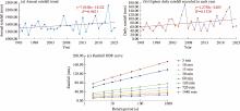
Fig. 5.
Rainfall characteristics of Kolkata based on 1993-2023 data. (a), annual rainfall trend; (b), the highest daily rainfall recorded in each year; (c), rainfall DDF curve."
Fig. 6.
Spatial distribution of runoff under rainfall scenario 1 (a) and rainfall scenario 2 (b) in Kolkata."
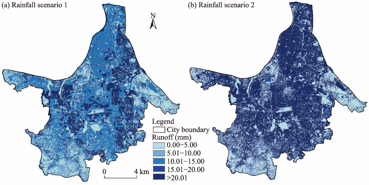
Table 5
Comparative overview of runoff potential under different rainfall scenarios."
| Runoff potential (mm) | Rainfall scenario 1 | Rainfall scenario 2 | ||
|---|---|---|---|---|
| Area (km2) | Area percentage (%) | Area (km2) | Area percentage (%) | |
| 0.00-5.00 | 68.78 | 34.45 | 59.52 | 29.82 |
| 5.01-10.00 | 0.76 | 0.38 | 0.00 | 0.00 |
| 10.01-15.00 | 108.18 | 54.19 | 9.26 | 4.64 |
| 15.01-20.00 | 0.00 | 0.00 | 0.76 | 0.38 |
| >20.01 | 21.91 | 10.98 | 130.09 | 65.16 |
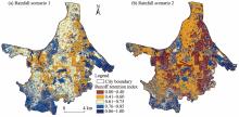
Fig. 7.
Spatial distribution of runoff retention index under rainfall scenario 1 (a) and rainfall scenario 2 (b) in Kolkata."

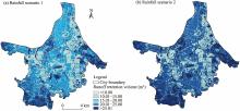
Fig. 8.
Spatial distribution of runoff retention volume under rainfall scenario 1 (a) and rainfall scenario 2 (b) in Kolkata."

Table 6
Runoff retention index values and runoff retention volume across different LULC types under two rainfall scenarios."
| LULC type | Runoff retention index | Runoff retention volume (m3) | ||
|---|---|---|---|---|
| Rainfall scenario 1 | Rainfall scenario 2 | Rainfall scenario 1 | Rainfall scenario 2 | |
| Grassland | 0.82 | 0.72 | 24.28 | 29.41 |
| Water bodies | 0.98 | 0.98 | 29.64 | 40.82 |
| Road | 0.17 | 0.13 | 4.95 | 5.11 |
| Herbaceous wetland | 0.96 | 0.96 | 29.64 | 40.82 |
| Bare/open land | 0.60 | 0.50 | 17.80 | 20.24 |
| Tree-covered land | 0.84 | 0.75 | 24.97 | 30.43 |
| Built-up area | 0.50 | 0.40 | 14.79 | 16.52 |
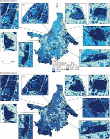
Fig. 9.
Runoff retention capacity of BGI under rainfall scenario 1 (a) and rainfall scenario 2 (b) in Kolkata."

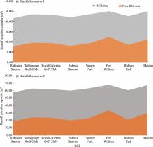
Fig. 10.
Average runoff retention capacity of BGI areas and non-BGI areas under rainfall scenario 1 (a) and rainfall scenario 2 (b) in Kolkata."
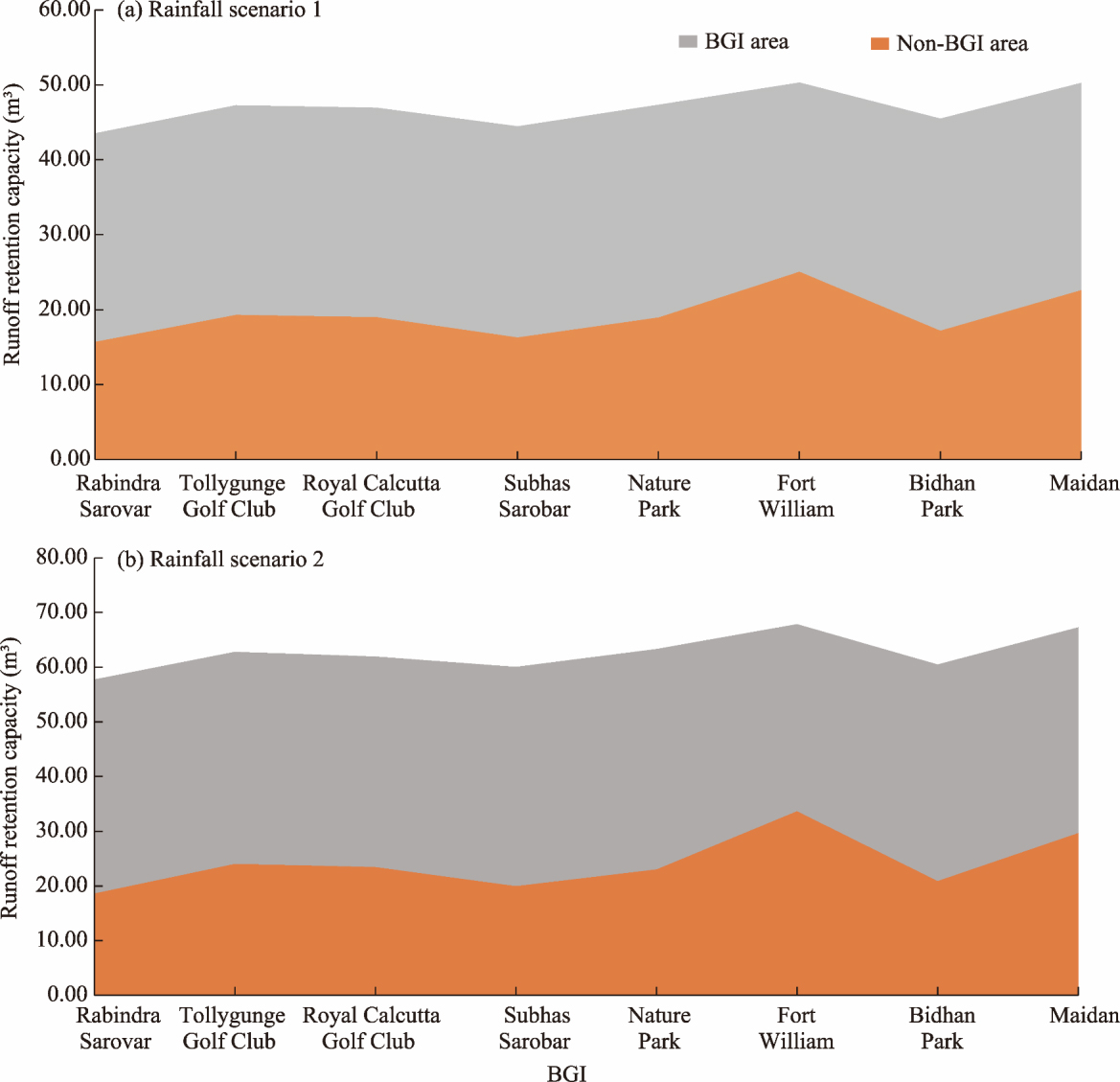
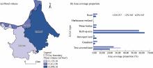
Fig. 11.
Spatial distribution of flood volume generated in the three micro-watersheds (i.e., 2A1A5, 2A1A6, and 2A1A7) under rainfall scenario 1 (a) and area coverage proportions of the corresponding LULC types across the three micro-watersheds (b) in Kolkata."
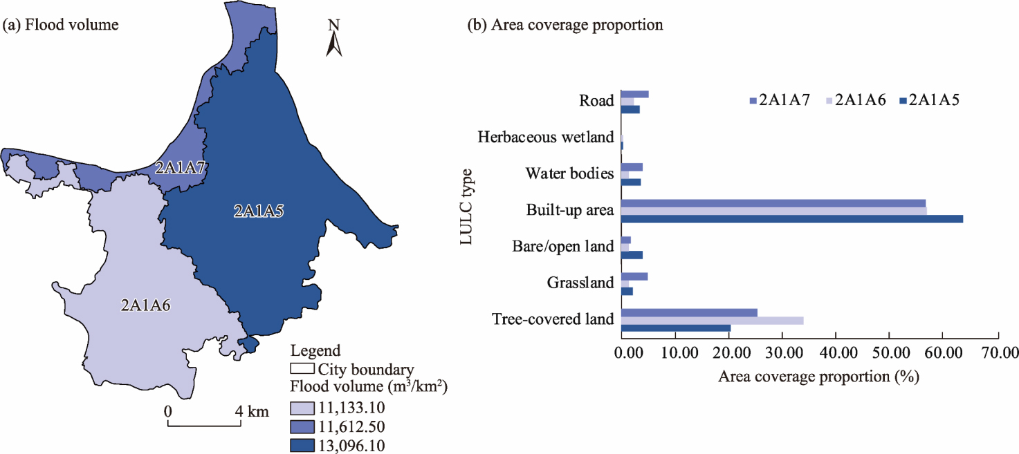
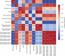
Fig. 12.
Correlation matrix illustrating the relationships among LULC types, flood volume, runoff retention index, and runoff retention volume under two rainfall scenarios across the three micro-watersheds in Kolkata."

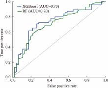
Fig. 13.
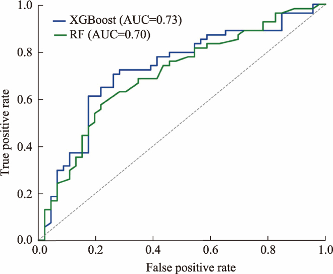
Validation of the UFRM model outputs against SAR-derived flood data using RF and XGBoost models. The grey dashed line represents the performance of a random classifier (the area under the curve (AUC)=0.50), while curves above this line indicate predictive skill better than random chance."
| [1] |
Abedi R., Costache R., Shafizadeh-Moghadam H., et al., 2022. Flash-flood susceptibility mapping based on XGBoost, random forest and boosted regression trees. Geocarto International. 37(19), 5479-5496.
doi: 10.1080/10106049.2021.1920636 |
| [2] |
Ahmed I.A., Talukdar S., Shahfahad, et al., 2022. Flood susceptibility modeling in the urban watershed of Guwahati using improved metaheuristic-based ensemble machine learning algorithms. Geocarto International. 37(26), 12238-12266.
doi: 10.1080/10106049.2022.2066200 |
| [3] | Ali H., Modi P., Mishra V., 2019. Increased flood risk in Indian sub-continent under the warming climate. Weather and Climate Extremes. 25, 100212, doi: 10.1016/j.wace.2019.100212. |
| [4] |
Almaaitah T., Appleby M., Rosenblat H., et al., 2021. The potential of Blue-Green infrastructure as a climate change adaptation strategy: A systematic literature review. Blue-Green Systems. 3(1), 223-248.
doi: 10.2166/bgs.2021.016 |
| [5] | Anand G., Marcotullio P.J., 2024. Spatial disparities in flood vulnerability in New York City. Journal of Hospital Management and Health Policy. 8(4), doi: 10.21037/jhmhp-23-92. |
| [6] |
Axelsson C., Soriani S., Culligan P., et al., 2020. Urban policy adaptation toward managing increasing pluvial flooding events under climate change. Journal of Environmental Planning and Management. 64(8), 1408-1427.
doi: 10.1080/09640568.2020.1823346 |
| [7] |
Berne A., Delrieu G., Creutin J., et al., 2004. Temporal and spatial resolution of rainfall measurements required for urban hydrology. Journal of Hydrology. 299(3-4), 166-179.
doi: 10.1016/S0022-1694(04)00363-4 |
| [8] | Bibi T.S., 2022. Modeling urban stormwater management in the town of Dodola based on landuse and climate change using SWMM 5.1. Journal of Hydrology: Regional Studies. 44, 101267, doi: 10.1016/j.ejrh.2022.101267. |
| [9] | Bose S., Mazumdar A., 2023. Urban flood risk assessment and mitigation with InVEST-UFRM model: a case study on Kolkata City, West Bengal State (India). Arabian Journal of Geosciences. 16, 320, doi: 10.1007/s12517-023-11412-2. |
| [10] | Bose S., Mazumdar A., Halder S., 2024. Groundwater sustainability in the face of urban expansion: A case study on Kolkata’s ongoing challenge. Groundwater for Sustainable Development. 25, 101162, doi: 10.1016/j.gsd.2024.101162. |
| [11] | Brears R.C., 2023. Blue-Green Infrastructure in Managing Urban Water Resources. London: Palgrave Macmillan UK. |
| [12] | Chow V.T., Maidment D.R., Mays L.W., 2019. Applied Hydrology. New York: McGraw-Hill Education. |
| [13] | Dasgupta S., Gosain A.K., Rao S., et al., 2013. A megacity in a changing climate: the case of Kolkata. Climatic Change. 116, 747-766. |
| [14] | Deepak Kumar S., Shahnawaz, Shekhar S., 2023. Evaluating urban green and blue spaces with space-based multi-sensor datasets for sustainable development. Computational Urban Science. 3(1), 12, doi: 10.1007/s43762-023-00091-0. |
| [15] | Demir S., Şahin E.K., 2022. Liquefaction prediction with robust machine learning algorithms (SVM, RF, and XGBoost) supported by genetic algorithm-based feature selection and parameter optimization from the perspective of data processing. Environmental Earth Sciences. 81(18), 459, doi: 10.1007/s12665-022-10578-4. |
| [16] | Depietri, Y., McPhearson T., 2017. Integrating the grey, green, and blue in cities:Nature-based solutions for climate change adaptation and risk reduction. In: Kabisch N., Korn, H., Stadler, J., et al., (eds.). Nature-Based Solutions to Climate Change Adaptation in Urban Areas. Cham: Springer International Publishing, 99-122. |
| [17] | Dhakal K.P., Chevalier L.R., 2016. Urban stormwater governance: The need for a paradigm shift. Environmental Management. 57, 1112-1124. |
| [18] | Dharmarathne G., Waduge A., Bogahawaththa M., et al., 2024. Adapting cities to the surge: A comprehensive review of climate-induced urban flooding. Results in Engineering. 22, 102123, doi: 10.1016/j.rineng.2024.102123. |
| [19] | Dong X.Y., Ye Y.M., Yang R.J., et al., 2023. Planning for green infrastructure based on integration of multi-driving factors: A case study in pilot site of sponge city. Sustainable Cities and Society. 93, 104549, doi: 10.1016/j.scs.2023.104549. |
| [20] | Fappiano F., Maurer M., Leitão J.P., 2025. Blue-Green Infrastructure for pluvial flood risk reduction in rapidly urbanizing peri-urban areas: Strategic planning for uncertain futures. Journal of Environmental Management. 395, 127843, doi: 10.1016/j.jenvman.2025.127843. |
| [21] | Fleck R., Westerhausen M., Killingsworth N., et al., 2022. The hydrological performance of a green roof in Sydney, Australia: A tale of two towers. Building and Environment. 221, 109274, doi: 10.1016/j.buildenv.2022.109274. |
| [22] |
Gillefalk M., Tetzlaff D., Hinkelmann R., et al., 2021. Quantifying the effects of urban green space on water partitioning and ages using an isotope-based ecohydrological model. Hydrology and Earth System Sciences. 25(6), 3635-3652.
doi: 10.5194/hess-25-3635-2021 |
| [23] | Green D., Johnson M., Slater L., et al., 2021. Green infrastructure: The future of urban flood risk management? Wiley Interdisciplinary Reviews: Water. 8(6), 1560, doi: 10.1002/wat2.1560. |
| [24] |
Gupta A., De B., 2024. A systematic review on urban blue-green infrastructure in the South Asian region: Recent advancements, applications, and challenges. Water Science and Technology. 89(2), 382-403.
doi: 10.2166/wst.2024.014 pmid: 39219137 |
| [25] | Hamaamin Y.A., 2017. Developing of rainfall intensity-duration-frequency model for Sulaimani City. Journal of Zankoy Sulaimani. 19(3), 93-102. |
| [26] | Hamel P., Guerry A.D., Polasky S., et al., 2021. Mapping the benefits of nature in cities with the InVEST software. npj Urban Sustainability. 1(1), 25, doi: 10.1038/s42949-021-00027-9. |
| [27] |
Hamel P., Tan L., 2021. Blue-green infrastructure for flood and water quality management in Southeast Asia: evidence and knowledge gaps. Environmental Management. 69(4), 699-718.
doi: 10.1007/s00267-021-01467-w pmid: 33860825 |
| [28] |
Hettiarachchi S., Wasko C., Sharma A., 2018. Increase in flood risk resulting from climate change in a developed urban watershed: The role of storm temporal patterns. Hydrology and Earth System Sciences. 22(3), 2041-2056.
doi: 10.5194/hess-22-2041-2018 |
| [29] | Hua P., Yang W.Y., Qi X.C., et al., 2019. Evaluating the effect of urban flooding reduction strategies in response to design rainfall and low impact development. Journal of Cleaner Production. 242(8), 118515, doi: 10.1016/j.jclepro.2019.118515. |
| [30] | Iliadis C., Galiatsatou P., Glenis V., et al., 2023. Urban flood modelling under extreme rainfall conditions for building-level flood exposure analysis. Hydrology. 10(8), 172, doi: 10.3390/hydrology10080172. |
| [31] | Islam M.R., Talukdar S., Rihan M., et al., 2024. Evaluating cooling effect of blue-green infrastructure on urban thermal environment in a metropolitan city: Using geospatial and machine learning techniques. Sustainable Cities and Society. 113, 105666, doi: 10.1016/j.scs.2024.105666. |
| [32] | Kadaverugu A., Nageshwar Rao C., Viswanadh G.K., 2021. Quantification of flood mitigation services by urban green spaces using InVEST model: A case study of Hyderabad City, India. Modeling Earth Systems and Environment. 7, 589-602. |
| [33] |
Karmaksh A.K., Kumar A., 2026. Urban development and water bodies in Indian cities: a systematic review of reciprocal relationships. Water Policy. 28(2), 316-332.
doi: 10.2166/wp.2026.160 |
| [34] | Kaur L., Rishi M., Sharma S., et al., 2019. Impervious surfaces an indicator of hydrological changes in urban watershed: A review. Journal of Environmental and Soil Sciences. 4(1), 469-473. |
| [35] | Kaur R., Gupta K., 2022. Blue-Green Infrastructure (BGI) network in urban areas for sustainable storm water management: A geospatial approach. City and Environment Interactions. 16, 100087, doi: 10.1016/j.cacint.2022.100087. |
| [36] | Kõiv-Vainik M., Kill K., Espenberg M., et al., 2022. Urban stormwater retention capacity of nature-based solutions at different climatic conditions. Nature-Based Solutions. 2, 100038, doi: 10.1016/j.nbsj.2022.100038. |
| [37] |
Krivtsov V., Forbes H., Birkinshaw S., et al., 2022. Ecosystem services provided by urban ponds and green spaces: A detailed study of a semi-natural site with global importance for research. Blue-Green Systems. 4(1), 1-23.
doi: 10.2166/bgs.2022.021 |
| [38] | Kumar A., Kanga S., Taloor A.K., et al., 2021. Surface runoff estimation of Sind River basin using integrated SCS-CN and GIS techniques. HydroResearch. 4, 61-74. |
| [39] | Leta B.M., Adugna D., 2024. Quantifying flood risk using InVEST-UFRM model and mitigation strategies: The case of Adama City, Ethiopia. Modeling Earth Systems and Environment. 10, 3257-3277. |
| [40] | Li B.F., Shi X., Lian L.S., et al., 2020. Quantifying the effects of climate variability, direct and indirect land use change, and human activities on runoff. Journal of Hydrology. 584, 124684, doi: 10.1016/j.jhydrol.2020.124684. |
| [41] | Liu W., Chen W.P., Peng C., 2015. Assessing the effectiveness of green infrastructures on urban flooding reduction: A community scale study. Ecological Modelling. 318, 6-14. |
| [42] | Mahdi E.S., Mohamedmeki M.Z., 2020. Analysis of rainfall intensity-duration-frequency (IDF) curves of Baghdad city. IOP Conference Series: Materials Science and Engineering. 888, 012066, doi: 10.1088/1757-899X/888/1/012066. |
| [43] | Mitra D., Banerji S., 2016. Pluvial flooding in Kolkata: A case study of the major streets in Northern, Southern and Central Kolkata. International Journal of Current Research and Academic Review. 4(5), 51-65. |
| [44] | Mohammadifar A., Gholami H., Golzari S., 2023. Novel integrated modelling based on multiplicative long short-term memory (mLSTM) deep learning model and ensemble multi-criteria decision making (MCDM) models for mapping flood risk. Journal of Environmental Management. 345, 118838, doi: 10.1016/j.jenvman.2023.118838. |
| [45] | Mukherjee A.B., Bardhan S., 2018. Studies on flood vulnerability assessment of Kolkata under a changing climate: A quantitative inferential approach. SPANDREL - International Journal of SPA. 13, 3-13. |
| [46] |
Mukherjee A.B., Bardhan S., 2021. Flood vulnerability and slum concentration mapping in the Indian city of Kolkata: A post-Amphan analysis. Water Science. 35(1), 109-126.
doi: 10.1080/23570008.2021.1957641 |
| [47] | Mukherjee S., Kar S., Bhattacharyya T., et al., 2025. Integrated catchment and coastal management for resilient urban flood mitigation under climate change. Frontiers in Water. 7, 1574309, doi: 10.3389/frwa.2025.1574309. |
| [48] |
Naresh A., Naik M.G., 2023. Urban rainfall-runoff modeling using HEC-HMS and artificial neural networks: A case study. International Journal of Mathematical, Engineering and Management Sciences. 8(3), 403-423.
doi: 10.33889/24557749 |
| [49] | NRCS Natural Resources Conservation Service, 2004. Chapter 10:Estimation of direct runoff from storm rainfall. In: NRCS, (ed.). National Engineering Handbook. Washington DC: United States Department of Agriculture. |
| [50] |
O’Donnell E., Thorne C., Ahilan S., et al., 2020. The blue-green path to urban flood resilience. Blue-Green Systems. 2(1), 28-45.
doi: 10.2166/bgs.2019.199 |
| [51] | Office of the Registrar General and Census Commissioner, 2011. Census of India 2011. [2024-12-20]. https://censusindia.gov.in. |
| [52] | Paudel S., States S.L., 2023. Urban green spaces and sustainability: Exploring the ecosystem services and disservices of grassy lawns versus floral meadows. Urban Forestry & Urban Greening. 84, 127932, doi: 10.1016/j.ufug.2023.127932. |
| [53] | Pauleit, S., Liu L., Ahern J., et al., 2011. Multifunctional green infrastructure planning to promote ecological services in the city. In:Niemelä, J., Breuste J.H., Elmqvist T., (eds.). Urban Ecology:Patterns, Processes. Oxford: Oxford University Press, 272-285. |
| [54] | Pochodyla E., Glińska-Lewczuk K., Jaszczak A., 2021. Blue-green infrastructure as a new trend and an effective tool for water management in urban areas. Landscape Online. 92, 1-20. |
| [55] | Quagliolo C., Roebeling P., Matos F., et al., 2023. Pluvial flood adaptation using nature-based solutions: An integrated biophysical-economic assessment. Science of The Total Environment. 902, 166202, doi: 10.1016/j.scitotenv.2023.166202. |
| [56] | Rahman, M.R., Rahman A., 2023. Urban green and blue spaces dynamics—A geospatial analysis using remote sensing, machine learning and landscape metrics in Rajshahi Metropolitan City, Bangladesh. In: Rahman A., Sen Roy, S., Talukdar, S., et al.,(eds.). Advancements in Urban Environmental Studies. Cham: Springer International Publishing, 233-252. |
| [57] | Rahman M.R., Kang S., Lee S., et al., 2025. A green infrastructure planning approach for enhanced flood control and resilience in urban areas. Land Use Policy. 153, 107535, doi: 10.1016/j.landusepol.2025.107535. |
| [58] |
Rainey J.L., Brody S.D., Galloway G.E., et al., 2021. Assessment of the growing threat of urban flooding: A case study of a national survey. Urban Water Journal. 18(5), 375-381.
doi: 10.1080/1573062X.2021.1893356 |
| [59] | Reyes-Riveros R., Altamirano A., De La Barrera F., et al., 2021. Linking public urban green spaces and human well-being: A systematic review. Urban Forestry & Urban Greening. 61, 127105, doi: 10.1016/j.ufug.2021.127105. |
| [60] | Ross C.W., Prihodko L., Anchang J.Y., et al., 2018. Global hydrologic soil groups (HYSOGs250m) for curve number-based runoff modeling. [2024-12-12]. https://doi.org/10.3334/ORNLDAAC/1566. |
| [61] | Roy S., Byrne J., Pickering C., 2012. A systematic quantitative review of urban tree benefits, costs, and assessment methods across cities in different climatic zones. Urban Forestry & Urban Greening. 11(4), 351-363. |
| [62] |
Rumbach A., 2017. At the roots of urban disasters: Planning and uneven geographies of risk in Kolkata, India. Journal of Urban Affairs. 39(6), 783-799.
doi: 10.1080/07352166.2017.1282771 |
| [63] | Russo A., Cirella G.T., 2021. Urban ecosystem services: Current knowledge, gaps, and future research. Land. 10(8), 811, doi: 10.3390/land10080811. |
| [64] | Seto K.C., Güneralp B., Hutyra L.R., 2012. Global forecasts of urban expansion to 2030 and direct impacts on biodiversity and carbon pools. Proceedings of the National Academy of Sciences. 109(40), 16083-16088. |
| [65] |
Shahfahad Naikoo, M. W. Das, T., et al., 2022. Prediction of land use changes at a metropolitan city using integrated cellular automata: Past and future. Geology, Ecology, and Landscapes. 8(3), 287-305.
doi: 10.1080/24749508.2022.2132010 |
| [66] | Shang X.X., Jiang X.H., Jia R.N., et al., 2019. Land use and climate change effects on surface runoff variations in the Upper Heihe River Basin. Water. 11(2), 344, doi: 10.3390/w11020344. |
| [67] | Shen C., Dong X., Wang L.Y., et al., 2024. Green infrastructure layout based on a dynamic operation feature of drainage systems. Water Science & Technology. 89(11), 2936-2950. |
| [68] |
Shuster W.D., Gehring R., Gerken J., 2014. Prospects for enhanced groundwater recharge via infltration of urban storm water runoff: A case study. Journal of Soil and Water Conservation. 62(3), 129-137.
doi: 10.1080/00224561.2007.12435939 |
| [69] | Sjöman J.D., Gill S.E., 2013. Residential runoff - The role of spatial density and surface cover, with a case study in the Höjeå River catchment, southern Sweden. Urban Forestry & Urban Greening. 13(2), 304-314. |
| [70] | Snikitha S., Kumar G.P., Dwarakish G.S., 2025. A comprehensive review of cutting-edge flood modelling approaches for urban flood resilience enhancement. Water Conservation Science and Engineering. 10(1), 2, doi: 10.1007/s41101-024-00327-y. |
| [71] | Sohn W., Kim J., Li M.H., et al., 2020. How does increasing impervious surfaces affect urban flooding in response to climate variability? Ecological Indicators. 118, 106774, doi: 10.1016/j.ecolind.2020.106774. |
| [72] | Talukdar, S., Roy S.K., Sarkar S.K., et al., 2022. Application of hybrid machine learning algorithms for flood susceptibility modeling. In: Pradhan B., Shit, P.K., Bhunia, G.S., et al., (eds.). Spatial Modelling of Flood Risk and Flood Hazards. Cham: Springer International Publishing, 233-252. |
| [73] | Talukdar S., Naikoo M.W., Rahman A., et al., 2024. Urban expansion and vegetation dynamics: The role of protected areas in preventing vegetation loss in a growing mega city. Habitat International. 150, 103129, doi: 10.1016/j.habitatint.2024.103129. |
| [74] |
Tuyls D.M., Thorndahl S., Rasmussen M.R., 2018. Return period assessment of urban pluvial floods through modelling of rainfall-flood response. Journal of Hydroinformatics. 20(4), 829-845.
doi: 10.2166/hydro.2018.133 |
| [75] |
White M.P., Elliott L.R., Grellier J., et al., 2021. Associations between green/blue spaces and mental health across 18 countries. Scientific Reports. 11(1), 8903, doi: 10.1038/s41598-021-87675-0.
pmid: 33903601 |
| [76] | Wu X., Moustakas S., Bezak N., et al., 2024. Assessing the performance of blue-green solutions through a fine-scale water balance model for an urban area. Science of The Total Environment. 948, 174750, doi: 10.1016/j.scitotenv.2024.174750. |
| [77] | Wu X., Willems P., 2025. Assessing blue-green infrastructures for urban flood and drought mitigation under changing climate scenarios. Journal of Hydrology: Regional Studies. 62, 102798, doi: 10.1016/j.ejrh.2025.102798. |
| [78] | Yao L., Chen L.D., Wei W., et al., 2014. Potential reduction in urban runoff by green spaces in Beijing: A scenario analysis. Urban Forestry & Urban Greening. 14(2), 300-308. |
| [79] | Yuanita C.N., Sagala S., 2025. Blue-green infrastructure in Jakarta’s fringe: An analysis of accessibility to blue-green spaces as a flood solution in Bekasi City. International Journal of Disaster Risk Reduction. 121, 105425, doi: 10.1016/j.ijdrr.2025.105425. |
| [80] | Zhang H., Zhang J.P., Fang H.Y., et al., 2022. Urban flooding response to rainstorm scenarios under different return period types. Sustainable Cities and Society. 87, 104184, doi: 10.1016/j.scs.2022.104184. |
| [81] | Zhou Q.Q., Leng G.Y., Su J.H., et al., 2019. Comparison of urbanization and climate change impacts on urban flood volumes: Importance of urban planning and drainage adaptation. Science of The Total Environment. 658, 24-33. |
| [82] | Zimmermann E., Bracalenti L., Piacentini R., et al., 2015. Urban flood risk reduction by increasing green areas for adaptation to climate change. Procedia Engineering. 161, 2241-2246. |
| [1] | Osman ZAKARI, Charles GYAMFI, Samuel Anim OFOSU, Ebenezer BOAKYE, Solomon Tawiah APAFO, Geophrey Kwame ANORNU, Bernard Nuoleyeng BAATUUWIE. Effects of land use and land cover changes on ecosystem services and functions in the Kulpawn River Basin of Ghana [J]. Regional Sustainability, 2025, 6(6): 100277-. |
| [2] | Jafarpour Ghalehteimouri KAMRAN, Che Ros FAIZAH, Rambat SHUIB. Application of Cellular Automata and Markov Chain model for urban green infrastructure in Kuala Lumpur, Malaysia [J]. Regional Sustainability, 2024, 5(4): 100179-. |
| [3] | SONG Boyi, ZHANG Shihang, LU Yongxing, GUO Hao, GUO Xing, WANG Mingming, ZHANG Yuanming, ZHOU Xiaobing, ZHUANG Weiwei. Characteristics and drivers of the soil multifunctionality under different land use and land cover types in the drylands of China [J]. Regional Sustainability, 2024, 5(3): 100162-. |
| [4] | Walid CHOUARI. Assessment of vegetation cover changes and the contributing factors in the Al-Ahsa Oasis using Normalized Difference Vegetation Index (NDVI) [J]. Regional Sustainability, 2024, 5(1): 100111-. |
| Viewed | ||||||
|
Full text |
|
|||||
|
Abstract |
|
|||||
 REGSUS Wechat
 新公网安备 65010402001202号