Regional Sustainability ›› 2024, Vol. 5 ›› Issue (2): 100142.doi: 10.1016/j.regsus.2024.100142
• Full Length Article • Previous Articles Next Articles
Alexandr Nikolaevich DUNETSa, Evgeniya Mikhailovna TABAKAEVAb,*( ), HAN Fangc
Received:2023-07-31
Revised:2024-01-30
Accepted:2024-06-05
Published:2024-06-30
Online:2024-07-25
Contact:
Evgeniya Mikhailovna TABAKAEVA
E-mail:tabakaevaem@mail.ru
Alexandr Nikolaevich DUNETS, Evgeniya Mikhailovna TABAKAEVA, HAN Fang. A system-integrated approach for the design of tourist areas at the local level under changing conditions: A case study in the Altay Mountains[J]. Regional Sustainability, 2024, 5(2): 100142.
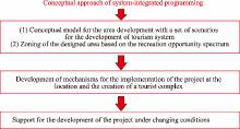
Fig. 1.
Stages in the design process based on the conceptual approach of system-integrated programming."
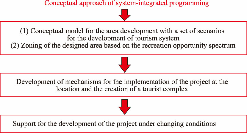
Fig. 2.
Cyclical process of analysis and decision-making for the design of tourist areas under changing conditions."
Table 1
Parameters for the design of tourist areas."
| Parameter | Description |
|---|---|
| Tourist activity | The elementary activities of tourists (tourist activities) together form the types of tourism in an area. The list of tourist activities, which includes thousands of varieties, varies among different destinations. Sociological studies make it possible to determine the types of tourists for certain tourist activities. |
| Attraction | Attractions include points of interest of various types: both the attractions themselves and sites with landscape attractiveness. In addition, there are facilities with a temporary concentration of visitor flows owing to functional needs. The assessment of the attractiveness level of sites is related to their significance for tourism development, including global, national, interregional, and regional significance. |
| Type of tourist areas | Researchers can determine the types of tourist areas according to the tourist development degree of the area (from initial development to intensive development) and the life cycle of the destination (Butler, |
| Functional zone in the area | Functional zones are determined considering the requirements of urban planning legislation, the spatial distribution of attractions, and the needs of tourists. Zoning provides scenarios at the destination level. |
| Scenario at the site level | Within the allocated functional zones, scenarios of tourist programs are formed. These scenarios consist of a combination of the types of tourist activities and their spatial distribution. For example, at the site level, summer and winter scenarios for tourist programs can be distinguished. During the process of design, identifying current and potential scenarios for tourist programs of a site is necessary. |
| Tourist facility | When analysing tourist facilities, it is necessary to consider the following issues: firstly, the quantitative and qualitative characteristics of the current tourist facilities of the site and their correspondence to activities and types of tourism; secondly, the degree of correspondence between tourist facilities and functional zones, the types of areas, the types of tourists, and the types of tourist activities; thirdly, the facilities for the conservation and development of attractions; and lastly, the life cycle stage of tourist facilities (including creation of a new object, long-term operation, and renovation). |
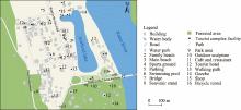
Fig. 3.
Location of the main attractions in the Biryuzovaya Katun tourist complex."
Fig. 4.
Heat map of visitor flow density in the Biryuzovaya Katun tourist complex during 09:00-12:00 (LST) based on hexagon grids with 5-m side length."
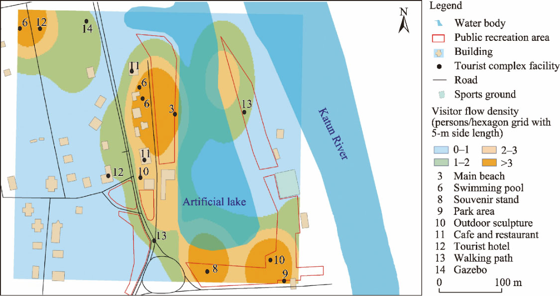
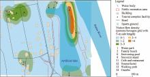
Fig. 5.
Heat map of visitor flow density in the Biryuzovaya Katun tourist complex during 13:00-14:00 (LST) based on hexagon grids with 5-m side length."
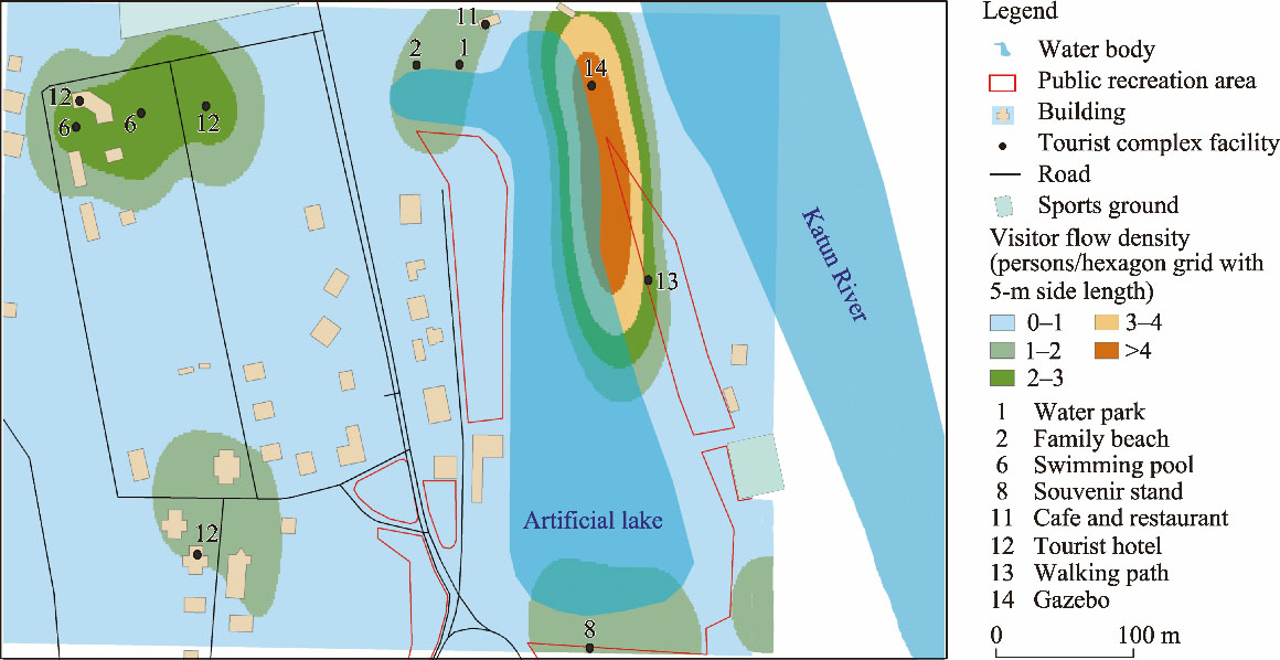
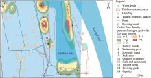
Fig. 6.
Heat map of visitor flow density in the Biryuzovaya Katun tourist complex during 14:00-15:00 (LST) based on hexagon grids with 5-m side length."
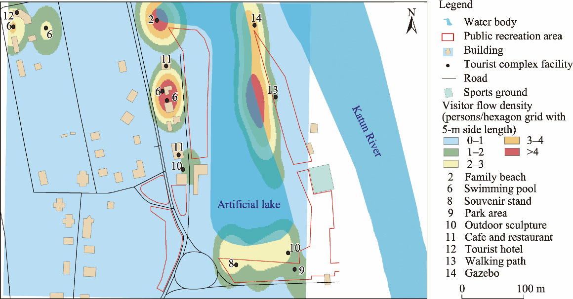
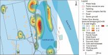
Fig. 7.
Heat map of visitor flow density in the Biryuzovaya Katun tourist complex during 16:00-18:00 (LST) based on hexagon grids with 5-m side length."
Fig. 8.
Location of the main attractions in the Belokurikha destination."
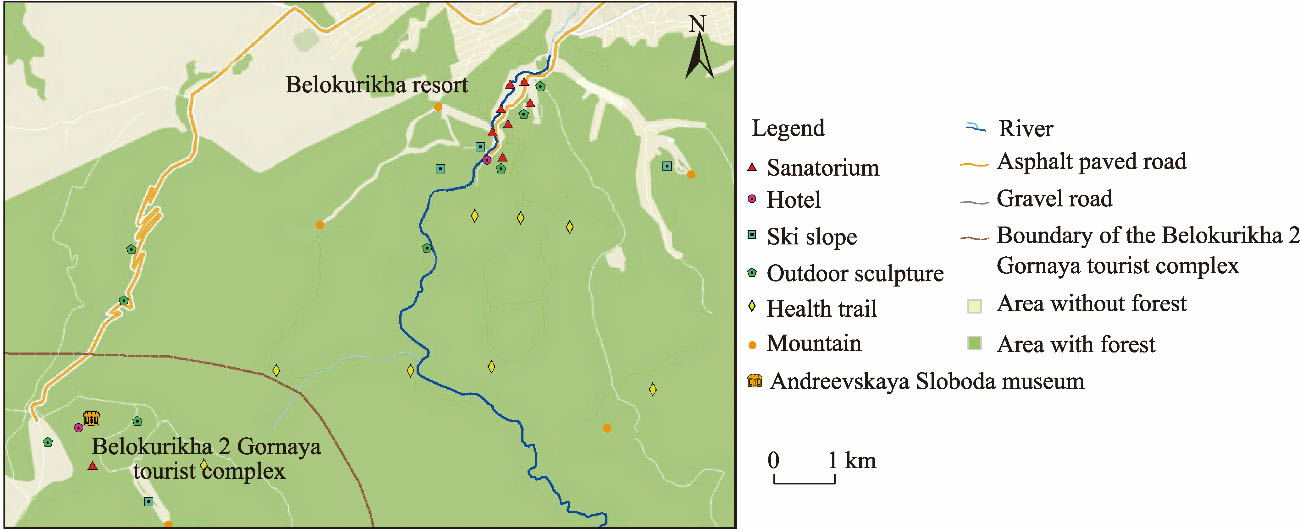
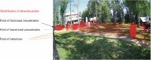
Fig. 9.
Visualization of visitor flow density based on video stream using the You Only Look Once (YOLO) v5 neural network detector in the surrounding areas of the Andreevskaya Sloboda museum in Belokurikha 2 Gornaya tourist complex."
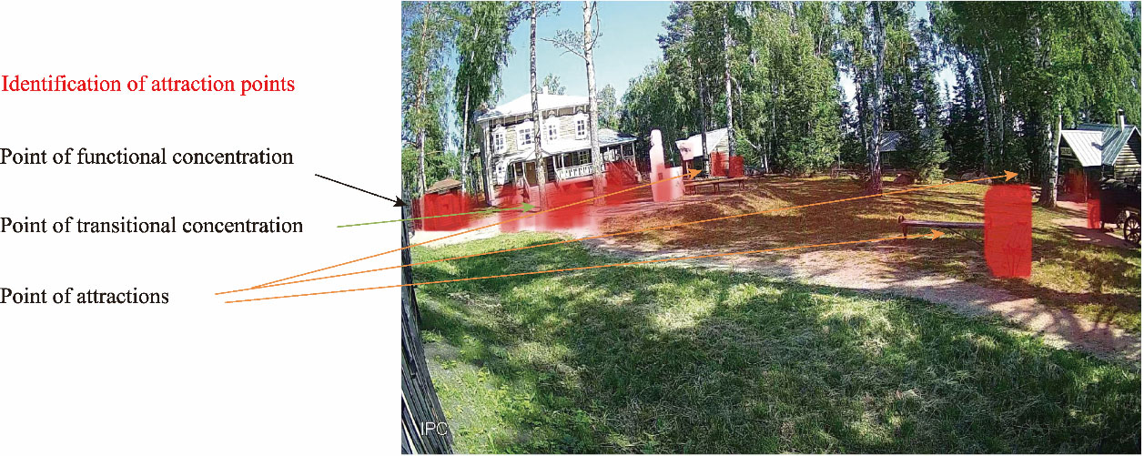
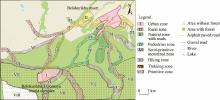
Fig. 10.
Area zoning of the Belokurikha destination."

| [1] | Afanasiev O.E., 2023. Tourist destinations: Design and development in a dynamically changing environment. Service and Tourism: Current Challenges. 17(2), 5-6 (in Russian). |
| [2] | Aladag O.F., Köseoglu M.A., King B., et al., 2020. Strategy implementation research in hospitality and tourism: Current status and future potential. Int. J. Hosp. Manag. 88, 102556, doi: 10.1016/j.ijhm.2020.102556. |
| [3] |
Arnberger A., Haider W., Brandenburg C., 2005. Evaluating visitor-monitoring techniques: A comparison of counting and video observation data. Environ. Manage. 36, 317-327.
pmid: 15995887 |
| [4] | Borkowski G., Młynarczyk A., 2019. Remote sensing using unmanned aerial vehicles for tourist recreation lake evaluation and development. Quaest. Geogr. 38(1), 5-14. |
| [5] | Burns P.M., Sancho M.M., 2003. Local perceptions of tourism planning: The case of Cuéllar, Spain. Tourism Manage. 24(3), 331-339. |
| [6] | Butler R., 1980. The concept of a tourist area cycle of evolution: Implications for management of resources. Can. Geogr. 24(1), 5-12. |
| [7] | Cevat T., Dallen J.T., 2001. Shortcomings in planning approaches to tourism development in developing countries: The case of Turkey. Int. J. Contemp. Hosp. M. 13(7), 352-359. |
| [8] | Chen B., Zhu Y., He X., et al., 2023. Analysis of high-quality tourism destinations based on spatiotemporal big data—A case study of Urumqi. Land. 12(7), 1425, doi: 10.3390/land12071425. |
| [9] | Cooper C., Gilbert D., Fletcher J., et al., 1993. Tourism: Principles and Practice. London: Longman Group. |
| [10] | Ćwiąkała P., Kocierz R., Puniach E., et al., 2018. Assessment of the possibility of using unmanned aerial vehicles (UAVs) for the documentation of hiking trails in alpine areas. Sensors. 18(1), 81, doi: 10.3390/s18010081. |
| [11] | Dunets A.N., Krupochkin E.P., 2012. Experience of using GIS-technologies for estimating the development of tourist-recreational area in the Altai-Sayan region. Izvestiya of Altai State University. 3(2), 115-119 (in Russian). |
| [12] | Dunets A.N., Krupochkin E.P., Tabakaeva E.M., et al., 2023. Unmanned aerial vehicles for analyzing the behavior of tourists on the “Biruzovaya Katun”. Regional Geosystems. 47(1), 88-100 (in Russian). |
| [13] | Dzhandzhugazova E.A., 2019. Tourist attractiveness of cultural heritage sites in specially protected tourist areas. [2024-01-20]. (in Russian). |
| [14] | Evstropyeva O.V., Bibaeva A.Y., Sanzheev E.D., 2019. Modeling tourist flows at the regional and local levels. Experience of implementation in the central ecological zone of the Baikal Natural Territory. Service and Tourism: Current Challenges. 13(1), 85-97 (in Russian). |
| [15] | Federal State Statistics Service, 2022. Results of the All-Russian Population Census-2020. [2024-01-20]. (in Russian)https://rosstat.gov.ru/vpn/2020/Tom1_Chislennost_i_razmeshchenie_naseleniya. |
| [16] | Gündüz M.Ş., Işık G., 2023. A new YOLO-based method for real-time crowd detection from video and performance analysis of YOLO models. Journal of Real-time Image Processing. 20(1), 5, doi: 10.1007/s11554-023-01276-w. |
| [17] | Gunn C.A., 2002. Tourism Planning:Basics, Concepts, Cases (4th ed.). New York: Routledge. |
| [18] | Hall C.M., 2008. Tourism Planning: Policies, Processes and Relationships (2nd ed.). Harlow: Pearson Education. |
| [19] | Hristić N.D., Stefanović N., Hristov M., 2023. Implementation instruments for developing sustainable tourism on recultivated land in the Middle Danube Flow. Sustainability. 15(9), 7724, doi: 10.3390/su15097724. |
| [20] | Indah F., Frido O., 2023. Investigating the Determining Factors of Tourist Revisit Intention in a Natural-based Tourism Destination. [2024-01-22]. https://www.e3s-conferences.org/articles/e3sconf/abs/2023/81/e3sconf_iconard2023_01014/e3sconf_iconard2023_01014.html. |
| [21] | Inskeep E., 1991. Tourism Planning:An Integrated and Sustainable Development Approach. New York: Van Nostrand Reinhold. |
| [22] | Inskeep E., 1994. National and Regional Tourism Planning: Methodologies and Case Studies. London: Routledge. |
| [23] | Jocher G., Changyu L., Hogan A., et al., 2020. Ultralytics/YOLOv5: Initial Release (v1.0). [2023-06-05]. https://zenodo.org/records/3908560. |
| [24] | Joyce K., Sutton S., 2009. A method for automatic generation of the recreation opportunity spectrum in New Zealand. Appl. Geogr. 29(3), 409-418. |
| [25] | Kachmarek Y., Stasyak A., Vlodarchik B., 2008. Tourist Product: Concept, Organization, Management. Moscow: Unity-dana (in Russian). |
| [26] | Kalinskaya A.V., Aseeva D.V., Dobrodomova T.N., 2021. The use of different methods of statistical collection and analysis of spatial-time data in tourism as a way to increase the level of economic security of the state. Economic Sciences. (3), 10-14 (in Russian). |
| [27] | Kandrot S., Hayes S., Holloway P., 2022. Applications of uncrewed aerial vehicles (UAV) technology to support integrated coastal zone management and the UN sustainable development goals at the coast. Estuar. Coast. 45(5), 1230-1249. |
| [28] | Kharlamova N.F., 2013. Climate of the Altai Region. Barnaul: Altai State University (in Russian). |
| [29] | Kharlamova N.F., Slazhneva S.S., 2021. Assessment of climatic conditions of the Altai Territory for the purposes of recreational activities. In: Shulanov, E.N., Ibraeva, A.G., Pashkov, S.V., et al., (eds.). Proceedings of the 9th International Scientific and Practical Conference:Current Problems of Natural Sciences. Petropavlovsk: Kozybayev University, 362-365 (in Russian). |
| [30] | King B., Pearlman M., 2009. Planning for tourism at local and regional levels:Principles, practices, and possibilities. In: JamalT., RobinsonM., (eds.). The SAGE Handbook of Tourism Studies. London: SAGE, 417-433. |
| [31] |
Lai K., Li Y., Feng X., 2006. Gap between tourism planning and implementation: A case of China. Tourism Manage. 27(6), 1171-1180.
doi: 10.1016/j.tourman.2005.11.009 pmid: 32287717 |
| [32] | Lupp G., Kantelberg V., Förster B., et al., 2021. Visitor counting and monitoring in forests using camera traps: A case study from Bavaria (Southern Germany). Land. 10(7), 736, doi: 10.3390/land10070736. |
| [33] | Manakov A.G., Golomidova E.S., Ivanov I.A., 2019. Estimation of the value of tourist flow within cross-border touristic-recreational regions in the north-west borderland of Russia. Proceedings of the Russian Geographical Society. 151(5), 18-31 (in Russian). |
| [34] | Manning R.E., Lime D.W., Hof M., et al., 1995. The visitor experience and resource protection (VERP) process: The application of carrying capacity to Arches National Park. The George Wright Forum. 12(3), 41-55. |
| [35] | Manning R.E., 1999. Studies in Outdoor Recreation: Search and Research for Satisfaction (2nd ed.). Corvallis: Oregon State University Press. |
| [36] | Martyshenko N.S., 2011. Estimation of spatial tourist allocation in Primorye in high season. Practical Marketing. (8), 17-25 (in Russian). |
| [37] | Mayer M., Staab J., Udas E., et al., 2021. Triggered trail camera images and machine learning based computer vision as alternative to established visitor monitoring approaches? In: Aas, Ø., Breiby, M., Selvaag, S.K., et al., (eds.). The 10th MMV Conference: Managing Outdoor Recreation Experiences in the Anthropocene - Resources, Markets, Innovations. Ås: Norwegian University of Life Sciences, 296-297. |
| [38] | McCahon S., Brinkman T., Klimstra R., 2023. Estimating encounter probabilities among recreational trail user groups. Journal of Outdoor Recreation and Tourism. 42, 100614, doi: 10.1016/j.jort.2023.100614. |
| [39] | McIntosh R.W., Goeldner C.R., Ritchie J.R.B., 1995. Tourism Principles, Practices, Philosophies. New York: Wiley. |
| [40] | Meng L., Liu Y., Wang Y., et al., 2021. A big-data approach for investigating destination image gap in Sanya City: When will the online and the offline goes parted? Regional Sustainability. 2(1), 98-108. |
| [41] | Mohsan S.A.H., Othman N.Q.H., Li Y., et al., 2023. Unmanned aerial vehicles (UAVs): Practical aspects, applications, open challenges, security issues, and future trends. Intel. Serv. Robot. 16, 109-137. |
| [42] | Muhar A., Zemann R., Lengauer M., 1995. Permanent Time-lapse Video Recording for the Quantification of Recreational Activities. [2023-06-05]. https://books.google.ru/books/about/Proceedings_Decision_Support_2001.html?id=wsgsAQAAMAAJ&redir_esc=y. |
| [43] | Mulyani A., Kurniadi D., Septiana Y., et al., 2020. Strategic planning for the implementation of tourism information systems. International Journal of Scientific & Technology Research. 9(2), 4714-4717. |
| [44] | Napierała T., Leśniewska-Napierała K., Cotella G., 2022. Contemporary Challenges of Spatial Planning in Tourism Destination. Łódź: Łódź University Press. |
| [45] | Novianti S., Fauzi C., Suhartanto D., 2020. Spatial analysis of tourist dispersal and mobility for tourism destination planning and development: A case study of great ocean road region, Australia. IOP Conf. Ser.: Mater. Sci. Eng. 830, 032081, doi: 10.1088/1757-899X/830/3/032081. |
| [46] | Qin S., Man J., Wang X., et al., 2019. Applying big data analytics to monitor tourist flow for the scenic area operation management. Discrete Dynamics in Nature and Society. 8239047, doi: 10.1155/2019/8239047. |
| [47] | Redmon J., Divvala S., Girshick R., et al., 2016. You Only Look Once:Unified, real-time object detection. In: Proceedings of the 2016 IEEE Conference on Computer Vision and Pattern Recognition (CVPR). New York, USA. |
| [48] | Rozīte M., Steina A., 2019. Tourism planning and strategy implementation: Practice in municipalities of Latvia. Research for Rural Development. 2, 161-168. |
| [49] | Russ T.H., 2002. Site Planning and Design Handbook. New York: McGraw-Hill. |
| [50] | Saarinen J., Rogerson C.M., Hall C.M., 2017. Geographies of tourism development and planning. Tourism Geogr. 19(3), 307-317. |
| [51] | Sestras P., Roşca S., Bilaşco S., et al., 2020. Feasibility assessments using unmanned aerial vehicle technology in heritage buildings: Rehabilitation-restoration, spatial analysis and tourism potential analysis. Sensors. 20(7), 2054, doi: 10.3390/s20072054. |
| [52] | Sevilla-Sevilla C., Mendieta-Aragón A., Ruiz-Gómez L.M., 2024. Drones in hospitality and tourism: A literature review and research agenda. Tourism Review. 79(2), 378-391. |
| [53] | Shahraki A.A., 2022. Tourism development techniques in the urban master plan. Cogent. Bus. Manag. 9(1), 2042977, doi: 10.1080/23311975. 2022.2042977. |
| [54] | Shepherd R., 1998. Tourism Principles and Practice. Harlow: Longman. |
| [55] | Staab J., Udas E., Mayer M., et al., 2021. Comparing established visitor monitoring approaches with triggered trail camera images and machine learning based computer vision. Journal of Outdoor Recreation and Tourism. 35, 100387, doi: 10.1016/j.jort.2021.100387. |
| [56] | Tabakaeva E.M., Dunets A.N., Akimov O.S., 2023. Low-mountain territories of Bolshaya Belokurikha: Tourism design based on the recreation opportunity spectrum. Sustainable Development of Mountain Territories. 15(1), 182-196 (in Russian). |
| [57] | Tikunov V.S., Belozerov V.S., Antipov S.O., et al., 2018. Social media as a tool for the analysis of tourist objects (case study of the Stavropol kraj). Lomonosov Geography Journal. (3), 89-95 (in Russian). |
| [58] | Tjørve E., 2022. The planning system in Norway with focus on mountain destinations. In: NapierałaT., Leśniewska-NapierałaK., CotellaG., (eds.). Contemporary Challenges of Spatial Planning in Tourism Destination. Łódź Łódź University Press, 45-60. |
| [59] | Todes A., Karam A., Klug N., et al., 2010. Beyond master planning? New approaches to spatial planning in Ekurhuleni, South Africa. Habitat Int. 34(4), 414-420. |
| [60] | Tosun C., Jenkins C.L., 1996. Regional planning approaches to tourism development: The case of Turkey. Tourism Manage. 17(7), 519-531. |
| [61] | Tumekh B., 2020. Development of a methodology for indicative planning of long-term development of the sphere of tourist services in the structure of the national economic system of developing countries. Science Review: Theory and Practice. 10(5), 898-910 (in Russian). |
| [62] | Tumová D., Pančíková L., Varmus M., et al., 2022. Prediction models in the managerial decision making on the application of UAVs in tourism. Journal of East European Research in Business and Economics. 968089, doi: 10.5171/2022.968089. |
| [63] | Veal A.J., 2002. Leisure and Tourism Policy and Planning (2nd ed.). New York: CABI Publishing. |
| [64] | Wu S., Wang L., Liu H., 2021. Study on tourism flow network patterns on May Day holiday. Sustainability. 13(2), 947, doi: 10.3390/su13020947. |
| [65] | Wyatt K.H., Arkema K.K., Wells-Moultrie S., et al., 2021. Integrated and innovative scenario approaches for sustainable development planning in the Bahamas. Ecol. Soc. 26(4), 23, doi: 10.5751/ES-12764-260423. |
| [66] | Yakovleva S.I., 2015. Bases of Territorial Design of Tourist Areas. Tver: Tver State University (in Russian). |
| [67] | Zeng W., Zhong Y., Li D., et al., 2021. Classification of recreation opportunity spectrum using night lights for evidence of humans and POI data for social setting. Sustainability. 13(14), 7782, doi: 10.3390/su13147782. |
| [68] | Zhong L., Sun S., Law R., et al., 2020. Investigate tourist behavior through mobile signal: Tourist flow pattern exploration in Tibet. Sustainability. 12(21), 9125, doi: 10.3390/su12219125. |
| No related articles found! |
| Viewed | ||||||
|
Full text |
|
|||||
|
Abstract |
|
|||||
 REGSUS Wechat
 新公网安备 65010402001202号