Regional Sustainability ›› 2021, Vol. 2 ›› Issue (2): 177-188.doi: 10.1016/j.regsus.2021.06.001
• Full Length Article • Previous Articles Next Articles
Guolin MAa,b, Jianli DINGa,b,*( ), Lijng HANa,b, Zipeng ZHANGa,b, Si RANa,b
Received:2020-12-01
Revised:2021-04-12
Accepted:2021-06-17
Online:2021-04-20
Published:2021-08-13
Contact:
Jianli DING
E-mail:watarid@xju.edu.cn
Guolin MA, Jianli DING, Lijng HAN, Zipeng ZHANG, Si RAN. Digital mapping of soil salinization based on Sentinel-1 and Sentinel-2 data combined with machine learning algorithms[J]. Regional Sustainability, 2021, 2(2): 177-188.

Fig. 1.
Locations of the sampling sites in the Ogan-Kuqa River Oasis (a) and demonstration of the landscape of the sampling sites (b and c)."

Table 1
Polarization combinations used in the study."
| Polarization combination | Reference | Polarization combination | Reference |
|---|---|---|---|
| VV | VH | ||
| VV+VH | VV2+VH2 | ||
| VV2+VH | VH2-VV | ||
| (VH2+VV2)/VH | 10 log(VH) | ||
| 10 log(VV) | 10 log(VV)+10 log(VH) |
Table 2
Calculation formulas of vegetation indices based on Sentinel-2."
| Vegetation index | Index acronym | Formula | Reference |
|---|---|---|---|
| Normalized Difference Vegetation Index | NDVI | $\frac{B8-B4}{B8+B4}$ | |
| Green Normalized Difference Vegetation Index | GNDVI | $\frac{B7-B3}{B7+B3}$ | |
| Weighted Difference Vegetation Index | WDVI | $B8-0.5\times B4$ | |
| Transformed Normalized Difference Vegetation Index | TNDVI | $\sqrt{\frac{\mathop{B}_{8}-\mathop{B}_{4}}{\mathop{B}_{8}+\mathop{B}_{4}}+0.5}$ | |
| Soil Adjusted Vegetation Index | SAVI | $\left( \frac{\mathop{B}_{8}-\mathop{B}_{4}}{\mathop{B}_{8}+\mathop{B}_{4}+0.5} \right)\times 1.5$ | |
| Infrared Percentage Vegetation Index | IPVI | $\frac{\mathop{B}_{8}}{\mathop{B}_{8}+\mathop{B}_{4}}$ | |
| Modified Chlorophyll Absorption Ratio Index | MCARI | $\left( \left( \mathop{B}_{5}-\mathop{B}_{4} \right)-0.2\left( \mathop{B}_{5}-\mathop{B}_{3} \right) \right)\times \frac{\mathop{B}_{5}}{\mathop{B}_{4}}$ | |
| Red Edge In-flection Point | REIP | $\frac{700+40\left( \left( \frac{\mathop{B}_{4}+\mathop{B}_{7}}{2} \right)-\mathop{B}_{5} \right)}{\mathop{B}_{6}-\mathop{B}_{5}}$ | |
| Modified Soil Adjusted Vegetation Index 2 | MSAVI2 | $\frac{2\mathop{B}_{8}-1-\sqrt{\mathop{\left( 2\mathop{B}_{8}+1 \right)}^{2}-8}}{2}$ | |
| Difference Vegetation Index | DVI | $\mathop{B}_{8}-\mathop{B}_{4}$ |
Table 3
Topography indices and acronym used in this study."
| Topography index | Index acronym | Reference |
|---|---|---|
| Digital Elevation Model (m) | DEM | |
| Slope | S | System for Automated Geoscientific Analyses (SAGA) GIS |
| Aspect | AS | SAGA GIS |
| Convergence Index | CI | SAGA GIS |
| Total catchment | TCA | SAGA GIS |
| Ls factor | LSF | SAGA GIS |
| Channel network base level | CNBL | SAGA GIS |
| Channel network distance | CND | SAGA GIS |
| Valley depth | VD | SAGA GIS |
| Relative slope position | RSP | SAGA GIS |
Table 4
Descriptive statistical analysis of the soil properties."
| Soil property | Maximum | Minimum | Mean | Median | SD | CV (%) |
|---|---|---|---|---|---|---|
| EC (dS/m) | 79.70 | 0.08 | 13.77 | 6.25 | 18.24 | 132.49 |
| SMC (%) | 20.28 | 0.52 | 9.60 | 9.58 | 5.17 | 53.89 |
| pH | 10.21 | 7.96 | 8.80 | 8.68 | 0.43 | - |

Fig. 2.
Correlation coefficients between measured electrical conductivity (EC) values and SAR indices (a), between measured EC values and vegetation indices (b), and between measured EC values and topography indices (c). VV, the radar backscatter coefficient of vertical polarization; VH, the radar backscatter coefficient of horizontal polarization; NDVI, Normalized Difference Vegetation Index; GNDVI, Green Normalized Difference Vegetation Index; WDVI, Weighted Difference Vegetation Index; TNDVI, Transformed Normalized Difference Vegetation Index; SAVI, Soil Adjusted Vegetation Index; IPVI, Infrared Percentage Vegetation Index; MCARI, Modified Chlorophyll Absorption Ratio Index; REIP, Red Edge In-flection Point; MSAVI2, Modified Soil Adjusted Vegetation Index 2; DVI, Difference Vegetation Index; DEM, Digital Elevation Model; S, Slope; AS, Aspect; CI, Convergence Index; TCA, Total catchment; LSF, Ls factor; CNBL, channel network base level; CND, channel network distance; VD, valley depth; RSP, relative slope position. **, significance at the 0.01 probability level; *, significance at the 0.05 probability level."

Table 5
Evaluation of the prediction effects of the different models in predicting EC."
| Model | Modeling technique | R2 | RMSE (dS/m) | RPD |
|---|---|---|---|---|
| Model A | CART | 0.52 | 12.92 | 1.44 |
| RF | 0.52 | 12.91 | 1.44 | |
| XGBoost | 0.59 | 11.99 | 1.55 | |
| Model B | CART | 0.57 | 12.20 | 1.53 |
| RF | 0.63 | 11.41 | 1.63 | |
| XGBoost | 0.68 | 10.56 | 1.77 |
Table 6
Main hyperparameters of the different models."
| Model | CART | RF | XGBoost |
|---|---|---|---|
| Model A | Criterion=‘mse’, Max_depth=4, Max_features=11, Max_leaf_nodes=11 | Criterion=‘mse’, N_estimators=7, Max_features=8 | N_estimators=15, Learning_rate=0.4, Max_depth=3 |
| Model B | Criterion=‘mse’, Max_depth=12, Max_features=10, Max_leaf_nodes=29 | Criterion=‘mse’, N_estimators=8, Max_features=15 | N_estimators=3, Learning_rate=0.3, Max_depth=5 |
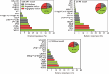
Fig. 3.
Relative importance of the predictor variables in the Model B for EC prediction using CART model (a), RF model (b), and XGBoost model (c). Model B means that the combination of vegetation indices, topography indices, and SAR indices is used as a predictor variable."


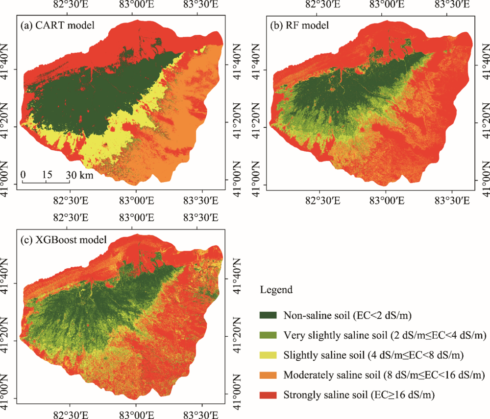
Fig. 4.
Prediction maps of soil salinization based on Model B using CART model (a), RF model (b), and XGBoost model (c)."
| [1] |
Abdel-Kader F.H., 2011. Digital soil mapping at pilot sites in the northwest coast of Egypt: A multinomial logistic regression approach. The Egyptian Journal of Remote Sensing and Space Science. 14(1), 29-40.
doi: 10.1016/j.ejrs.2011.04.001 |
| [2] |
Akramkhanov A., Martius C., Park S.J., et al., 2011. Environmental factors of spatial distribution of soil salinity on flat irrigated terrain. Geoderma. 163(1-2), 55-62.
doi: 10.1016/j.geoderma.2011.04.001 |
| [3] |
Alexakis D.D., Mexis F.D.K., Vozinaki A.E.K., et al., 2017. Soil moisture content estimation based on sentinel-1 and auxiliary earth observation products. A hydrological approach. Sensors. 17(6), 1455.
doi: 10.3390/s17061455 |
| [4] | Allbed A., Kumar L., Aldakheel Y.Y., 2014. Assessing soil salinity using soil salinity and vegetation indices derived from IKONOS high-spatial resolution imageries: Applications in a date palm dominated region. Geoderma. (230-231), 1-8. |
| [5] |
Aubert M., Baghdadi N., Zribi M., et al., 2011. Analysis of TerraSAR-X data sensitivity to bare soil moisture, roughness, composition and soil crust. Remote Sens. Environ. 115(8), 1801-1810.
doi: 10.1016/j.rse.2011.02.021 |
| [6] |
Baghdadi N., Boyer N., Todoroff P., et al., 2009. Potential of SAR sensors TerraSAR-X, ASAR/ENVISAT and PALSAR/ALOS for monitoring sugarcane crops on Reunion Island. Remote Sens. Environ. 113(8), 1724-1738.
doi: 10.1016/j.rse.2009.04.005 |
| [7] |
Bakr N., Ali R.R., 2019. Statistical relationship between land surface altitude and soil salinity in the enclosed desert depressions of arid regions. Arab. J. Geosci. 12(23), 715.
doi: 10.1007/s12517-019-4969-9 |
| [8] |
Beguin J., Fuglstad G.A., Mansuy N., et al., 2017. Predicting soil properties in the Canadian boreal forest with limited data: Comparison of spatial and non-spatial statistical approaches. Geoderma. 306, 195-205.
doi: 10.1016/j.geoderma.2017.06.016 |
| [9] | Breiman L., Friedman J., Olshen R., et al., 1984. Classification and regression tress. Encyclopedia of Ecology. 40(3), 582-588. |
| [10] |
Breiman L., 2001. Random forests. Mach. Learn. 45(1), 5-32.
doi: 10.1023/A:1010933404324 |
| [11] |
Castaldi F., Hueni A., Chabrillat S., et al., 2019. Evaluating the capability of the Sentinel-2 data for soil organic carbon prediction in croplands. ISPRS-J. Photogramm. Remote Sens. 147, 267-282.
doi: 10.1016/j.isprsjprs.2018.11.026 |
| [12] |
Chang C.W., Laird D.A., Mausbach M.J., et al., 2001. Near-infrared reflectance spectroscopy-principal components regression analyses of soil properties. Soil Sci. Soc. Am. J. 65(2), 480-490.
doi: 10.2136/sssaj2001.652480x |
| [13] | Chen S., Liang Z., Webster R., et al., 2019. A high-resolution map of soil pH in China made by hybrid modelling of sparse soil data and environmental covariates and its implications for pollution. Sci. Total Environ. 665, 273-283. |
| [14] |
Clevers J.G.P.W,1989. Application of a weighted infrared-red vegetation index for estimating leaf area index by correcting for soil moisture. Remote Sens. Environ. 29(1), 25-37.
doi: 10.1016/0034-4257(89)90076-X |
| [15] |
Clevers J.G.P.W., Gitelson A.A., 2013. Remote estimation of crop and grass chlorophyll and nitrogen content using red-edge bands on Sentinel-2 and-3. Int. J. Appl. Earth Obs. Geoinf. 23, 344-351.
doi: 10.1016/j.jag.2012.10.008 |
| [16] |
Crippen R.E., 1990. Calculating the vegetation index faster. Remote Sens. Environ. 34(1), 71-73.
doi: 10.1016/0034-4257(90)90085-Z |
| [17] |
Daughtry C.S.T., Walthall C.L., Kim M.S., et al., 2000. Estimating corn leaf chlorophyll concentration from leaf and canopy reflectance. Remote Sens. Environ. 74(2), 229-239.
doi: 10.1016/S0034-4257(00)00113-9 |
| [18] | De Bernardis C., Vicente-Guijalba F., Martinez-Marin T., et al., 2016. Contribution to real-time estimation of crop phenological states in a dynamical framework based on NDVI time series: Data fusion with SAR and temperature. IEEE J. Sel. Top. Appl. Earth Observ. Remote. 9(8), 3512-3523. |
| [19] | Ding J.L., Yu D.L., 2014. Monitoring and evaluating spatial variability of soil salinity in dry and wet seasons in the Werigan-Kuqa Oasis, China, using remote sensing and electromagnetic induction instruments. Geoderma. 235, 316-322. |
| [20] |
Dong W., Wu T.J., Luo J.C., et al., 2019. Land parcel-based digital soil mapping of soil nutrient properties in an alluvial-diluvia plain agricultural area in China. Geoderma. 340, 234-248.
doi: 10.1016/j.geoderma.2019.01.018 |
| [21] |
Drusch M., Del Bello U., Carlier S., et al., 2012. Sentinel-2: ESA’s Optical High-Resolution Mission for GMES Operational Services. Remote Sens. Environ. 120, 25-36.
doi: 10.1016/j.rse.2011.11.026 |
| [22] | El Harti A., Lhissou R., Chokmani K., et al., 2016. Spatiotemporal monitoring of soil salinization in irrigated Tadla Plain (Morocco) using satellite spectral indices. IEEE J. Sel. Top. Appl. Earth Observ. 50, 64-73. |
| [23] | ESA,2015a. ESA Introducing Sentinel-1. [2021-06-08]. http://www.esa.int/Applications/Observing_the_Earth/Copernicus/Sentinel-1/Introducing_Sentinel-1. |
| [24] | ESA,2015b. ESA Introducing Sentinel-2. [2021-06-08]. http://www.esa.int/Applications/Observing_the_Earth/Copernicus/Sentinel-2/Introducing_Sentinel-2. |
| [25] |
Farahmand N., Sadeghi V., 2020. Estimating soil salinity in the dried lake bed of urmia lake using optical Sentinel-2 images and nonlinear regression models. J. Indian Soc. Remote Sens. 48(4), 675-687.
doi: 10.1007/s12524-019-01100-8 |
| [26] |
Fathizad H., Hakimzadeh Ardakani M.A., Sodaiezadeh H., et al., 2020. Investigation of the spatial and temporal variation of soil salinity using random forests in the central desert of Iran. Geoderma. 365, 114233.
doi: 10.1016/j.geoderma.2020.114233 |
| [27] |
Friedman J.H., 2001. Greedy function approximation: A gradient boosting machine. Ann. Stat. 29(5), 1189-1232.
doi: 10.1214/aos/1013203450 |
| [28] |
Galin E., Guerin E., Peytavie A., et al., 2019. A review of digital terrain modeling. Comput. Graph. Forum. 38(2), 553-577.
doi: 10.1111/cgf.13657 |
| [29] | Gallant J.C., Dowling T.I., 2003. A multiresolution index of valley bottom flatness for mapping depositional areas. Water Resour. Res. 39(12), 291-297. |
| [30] |
Gholizadeh A., Zizala D., Saberioon M., et al., 2018. Soil organic carbon and texture retrieving and mapping using proximal, airborne and Sentinel-2 spectral imaging. Remote Sens. Environ. 218, 89-103.
doi: 10.1016/j.rse.2018.09.015 |
| [31] |
Gitelson A.A., Merzlyak M.N., 1998. Remote sensing of chlorophyll concentration in higher plant leaves. Adv. Space Res. 22(5), 689-692.
doi: 10.1016/S0273-1177(97)01133-2 |
| [32] |
Guan X.Y., Wang S.L., Gao Z.Y., et al., 2013. Dynamic prediction of soil salinization in an irrigation district based on the support vector machine. Math. Comput. Model. 58(3-4), 719-724.
doi: 10.1016/j.mcm.2011.10.026 |
| [33] | Guyot G., Frederic B., Major D., 1988. High spectral resolution: Determination of spectral shifts between the red and the near infrared. Int. Arch. Photogramm. Remote. Sens. 11, 750-760. |
| [34] |
Hengl T., Mendes de Jesus J., Heuvelink G.B.M., et al., 2017. SoilGrids250m: Global gridded soil information based on machine learning. PLoS One. 12(2), e0169748.
doi: 10.1371/journal.pone.0169748 |
| [35] |
Hoa P.V., Giang N.V., Binh N.A., et al., 2019. Soil salinity mapping using SAR Sentinel-1 data and advanced machine learning algorithms: A case study at ben tre province of the mekong river delta (Vietnam). Rem. Sens. 11(2), 128.
doi: 10.3390/rs11020128 |
| [36] |
Holah N., Baghdadi N., Zribi M., et al., 2005. Potential of ASAR/ENVISAT for the characterization of soil surface parameters over bare agricultural fields. Remote Sens. Environ. 96(1), 78-86.
doi: 10.1016/j.rse.2005.01.008 |
| [37] |
Huete A.R., 1988. A soil-adjusted vegetation index (SAVI). Remote Sens. Environ. 25(3), 295-309.
doi: 10.1016/0034-4257(88)90106-X |
| [38] |
Ivushkin K., Bartholomeus H., Bregt A.K., et al., 2019. Global mapping of soil salinity change. Remote Sens. Environ. 231, 111260.
doi: 10.1016/j.rse.2019.111260 |
| [39] |
Jordan C.F., 1969. Derivation of leaf-area index from quality of light on the forest floor. Ecology. 50(4), 663-666.
doi: 10.2307/1936256 |
| [40] |
Kalambukattu J.G., Kumar S., Arya Raj R., 2018. Digital soil mapping in a Himalayan watershed using remote sensing and terrain parameters employing artificial neural network model. Environ. Earth Sci. 77(5), 203.
doi: 10.1007/s12665-018-7367-9 |
| [41] |
Kasischke E.S., Melack J.M., Dobson M.C., 1997. The use of imaging radars for ecological applications—A review. Remote Sens. Environ. 59(2), 141-156.
doi: 10.1016/S0034-4257(96)00148-4 |
| [42] |
Lamichhane S., Kumar L., Wilson B., 2019. Digital soil mapping algorithms and covariates for soil organic carbon mapping and their implications: A review. Geoderma. 352, 395-413.
doi: 10.1016/j.geoderma.2019.05.031 |
| [43] |
Li W.J., Fang H.Y., Qin G.X., et al., 2020. Concentration estimation of dissolved oxygen in Pearl River Basin using input variable selection and machine learning techniques. Sci. Total Environ. 731, 139099.
doi: 10.1016/j.scitotenv.2020.139099 |
| [44] |
Loiseau T., Chen S., Mulder V.L., et al., 2019. Satellite data integration for soil clay content modelling at a national scale. International Journal of Applied Earth Observations and Geoinformatio. 82, 101905.
doi: 10.1016/j.jag.2019.101905 |
| [45] | Ma C., 2018. Quantitative retrieval of soil salt content based on Sentinel-1 dual polarization radar image. Transactions of the Chinese Society of Agricultural Engineering. 34(2), 153-158 (in Chinese). |
| [46] |
Malenovsky Z., Rott H., Cihlar J., et al., 2012. Sentinels for science: Potential of Sentinel-1, -2, and -3 missions for scientific observations of ocean, cryosphere, and land. Remote Sens. Environ. 120, 91-101.
doi: 10.1016/j.rse.2011.09.026 |
| [47] |
Metternicht G.I., Zinck J.A., 2003. Remote sensing of soil salinity: potentials and constraints. Remote Sens. Environ. 85(1), 1-20.
doi: 10.1016/S0034-4257(02)00188-8 |
| [48] |
Muller S.J., van Niekerk A., 2016. An evaluation of supervised classifiers for indirectly detecting salt-affected areas at irrigation scheme level. Int. J. Appl. Earth Obs. Geoinf. 49, 138-150.
doi: 10.1016/j.jag.2016.02.005 |
| [49] |
Nawar S., Buddenbaum H., Hill J., et al., 2014. Modeling and mapping of soil salinity with reflectance spectroscopy and landsat data using two quantitative methods (PLSR and MARS). Rem. Sens. 6(11), 10813-10834.
doi: 10.3390/rs61110813 |
| [50] | Page K.L., Dalal R.C., Pringle M.J., et al., 2013. Organic carbon stocks in cropping soils of Queensland, Australia, as affected by tillage management, climate, and soil characteristics. Soil Res. 51(7-8), 584-595. |
| [51] |
Peng J., Biswas A., Jiang Q., et al., 2019. Estimating soil salinity from remote sensing and terrain data in southern Xinjiang Province, China. Geoderma. 337, 1309-1319.
doi: 10.1016/j.geoderma.2018.08.006 |
| [52] |
Qi J., Chehbouni A., Huete A.R., et al., 1994. A modified soil adjusted vegetation index. Remote Sens. Environ. 48(2), 119-126.
doi: 10.1016/0034-4257(94)90134-1 |
| [53] | Ramos T.B., Castanheira N., Oliveira A.R., et al., 2020. Soil salinity assessment using vegetation indices derived from Sentinel-2 multispectral data. application to Leziria Grande, Portugal. Agric. Water Manage. 241, 106387. |
| [54] |
Roelofsen H.D., van Bodegom P.M., Kooistra L., et al., 2015. An evaluation of remote sensing derived soil pH and average spring groundwater table for ecological assessments. Int. J. Appl. Earth Obs. Geoinf. 43, 149-159.
doi: 10.1016/j.jag.2015.05.005 |
| [55] |
Rudiyanto,Minasny B., Setiawan B.I., et al., 2018. Open digital mapping as a cost-effective method for mapping peat thickness and assessing the carbon stock of tropical peatlands. Geoderma. 313, 25-40.
doi: 10.1016/j.geoderma.2017.10.018 |
| [56] | Ruecker G.R., Agyare A., Akramhanov A., et al,2009. Influence of grid cell size and flow routing algorithm on soil-landform modeling. Journal of the Korean Geographical Society. 44(2), 122-145. |
| [57] |
Schuler U., Herrmann L., Ingwersen J., et al., 2010. Comparing mapping approaches at subcatchment scale in northern Thailand with emphasis on the Maximum Likelihood approach. Catena. 81(2), 137-171.
doi: 10.1016/j.catena.2010.02.003 |
| [58] |
Shahabi M., Jafarzadeh A.A., Neyshabouri M.R., et al., 2017. Spatial modeling of soil salinity using multiple linear regression, ordinary kriging and artificial neural network methods. Arch. Agron. Soil Sci. 63(2), 151-160.
doi: 10.1080/03650340.2016.1193162 |
| [59] |
Shen Q.S., Wang Y., Wang X.R., et al., 2019. Comparing interpolation methods to predict soil total phosphorus in the mollisol area of northeast China. Catena. 174, 59-72.
doi: 10.1016/j.catena.2018.10.052 |
| [60] |
Song C.Y., Ren H.X., Huang C., 2016. Estimating soil salinity in the Yellow River delta, eastern China—an integrated approach using spectral and terrain indices with the generalized additive model. Pedosphere. 26(5), 626-635.
doi: 10.1016/S1002-0160(15)60071-6 |
| [61] |
Sugimori Y., Funakawa S., Pachikin K.M., et al., 2008. Soil salinity dynamics in irrigated fields and its effects on paddy based rotation systems in southern Kazakhstan. Land Degrad. Dev. 19(3), 305-320.
doi: 10.1002/(ISSN)1099-145X |
| [62] |
Taghadosi M.M., Hasanlou M., Eftekhari K., 2019. Soil salinity mapping using dual-polarized SAR Sentinel-1 imagery. Int. J. Remote Sens. 40(1), 237-252.
doi: 10.1080/01431161.2018.1512767 |
| [63] |
Taghizadeh-Mehrjardi R., Minasny B., Sarmadian F., et al., 2014. Digital mapping of soil salinity in Ardakan region, central Iran. Geoderma. 213, 15-28.
doi: 10.1016/j.geoderma.2013.07.020 |
| [64] |
Tucker C.J., 1979. Red and photographic infrared linear combinations for monitoring vegetation. Remote Sens. Environ. 8(2), 127-150.
doi: 10.1016/0034-4257(79)90013-0 |
| [65] |
Vaudour E., Gomez C., Fouad Y., et al., 2019. Sentinel-2 image capacities to predict common topsoil properties of temperate and Mediterranean agroecosystems. Remote Sens. Environ. 223, 21-33.
doi: 10.1016/j.rse.2019.01.006 |
| [66] |
Vega F.A., Matías J.M., Andrade M.L., et al., 2009. Classification and regression trees (CARTs) for modelling the sorption and retention of heavy metals by soil. J. Hazard. Mater. 167(1), 615-624.
doi: 10.1016/j.jhazmat.2009.01.016 |
| [67] |
Wang J.Z., Ding J.L., Yu D.L., et al., 2019. Capability of Sentinel-2 MSI data for monitoring and mapping of soil salinity in dry and wet seasons in the Ebinur Lake region, Xinjiang, China. Geoderma. 353, 172-187.
doi: 10.1016/j.geoderma.2019.06.040 |
| [68] |
Wang J.Z., Ding J.L., Yu D.L., et al., 2020. Machine learning-based detection of soil salinity in an arid desert region, Northwest China: A comparison between Landsat-8 OLI and Sentinel-2 MSI. Sci. Total Environ. 707, 136092.
doi: 10.1016/j.scitotenv.2019.136092 |
| [69] |
Wei L.F., Yuan Z.R., Yu M., et al., 2019. Estimation of arsenic content in soil based on laboratory and field reflectance rpectroscopy. Sensors. 19(18), 3904.
doi: 10.3390/s19183904 |
| [70] |
Yahiaoui I., Douaoui A., Zhang Q., et al., 2015. Soil salinity prediction in the Lower Cheliff plain (Algeria) based on remote sensing and topographic feature analysis. J. Arid Land. 7(6), 794-805.
doi: 10.1007/s40333-015-0053-9 |
| [71] |
Yang R.M., Zhang G.L., Liu F., et al., 2016. Comparison of boosted regression tree and random forest models for mapping topsoil organic carbon concentration in an alpine ecosystem. Ecol. Indic. 60, 870-878.
doi: 10.1016/j.ecolind.2015.08.036 |
| [72] |
Yang R.M., Guo W.W., 2019. Using time-series Sentinel-1 data for soil prediction on invaded coastal wetlands. Environ. Monit. Assess. 191, 462.
doi: 10.1007/s10661-019-7580-3 |
| [73] | Yao Y., Ding J.L., Zhang F., et al., 2013. Monitoring of soil salinization in Northern Tarim Basin, Xinjiang of China in dry and wet seasons based on remote sensing. Chinese Journal of Applied Ecology. 24(11), 3213-3220 (in Chinese). |
| [74] | Yi Q.X., 2019. Remote estimation of cotton LAI using Sentinel-2 multispectral data. Transactions of the Chinese Society of Agricultural Engineering. 35(16), 189-197 (in Chinese). |
| [75] |
Yin L.L., Zhang H.H., Zhou X., et al., 2020. KAML: improving genomic prediction accuracy of complex traits using machine learning determined parameters. Genome Biol. 21(1), 146.
doi: 10.1186/s13059-020-02052-w |
| [76] |
Zamani Joharestani M., Cao C.X., Ni X.L., et al., 2019. PM2.5 prediction based on random rorest, XGBoost, and deep learning using multisource remote sensing data. Atmosphere. 2019,10(7), 373.
doi: 10.3390/atmos10070373 |
| [77] |
Zhang T.T., Zeng S.L., Gao Y., et al., 2011. Using hyperspectral vegetation indices as a proxy to monitor soil salinity. Ecol. Indic. 11(6), 1552-1562.
doi: 10.1016/j.ecolind.2011.03.025 |
| [78] |
Zhang Z.P., Ding J.L., Wang J.Z., et al., 2020a.Prediction of soil organic matter in northwestern China using fractional-order derivative spectroscopy and modified normalized difference indices. Catena. 185, 104257.
doi: 10.1016/j.catena.2019.104257 |
| [79] |
Zhang Z.P., Ding J.L., Zhu C.M., et al., 2020b.Combination of efficient signal pre-processing and optimal band combination algorithm to predict soil organic matter through visible and near-infrared spectra. Spectroc. Acta Pt. A-Molec. Biomolec. Spectr. 240(15), 118553.
doi: 10.1016/j.saa.2020.118553 |
| [80] |
Zhang Z.P., Ding J.L., Zhu C.L., et al., 2021. Strategies for the efficient estimation of soil organic matter in salt-affected soils through Vis-NIR spectroscopy: Optimal band combination algorithm and spectral degradation. Geoderma. 382, 114729.
doi: 10.1016/j.geoderma.2020.114729 |
| [81] | Zhang Z.T., Du Y.Y., Lao C.C., et al., 2020. Inversion model of soil salt content in different depths based on radar remote sensing. Transactions of The Chinese Society of Agricultural Machinery. 1-15 (in Chinese). |
| [82] |
Zheng Z., Zhang F.R., Ma F.Y., et al., 2009. Spatiotemporal changes in soil salinity in a drip-irrigated field. Geoderma. 149(3-4), 243-248.
doi: 10.1016/j.geoderma.2008.12.002 |
| [83] |
Zhou T., Zhao M.F., Sun C.L., et al., 2018. Exploring the impact of seasonality on urban land-cover mapping using multi-season Sentinel-1A and GF-1 WFV images in a subtropical monsoon-climate region. Isprs International Journal of Geo-Information. 7(1), 3.
doi: 10.3390/ijgi7010003 |
| [84] |
Zhou T., Geng Y.J., Chen J., et al., 2020. High-resolution digital mapping of soil organic carbon and soil total nitrogen using DEM derivatives, Sentinel-1 and Sentinel-2 data based on machine learning algorithms. Sci. Total Environ. 729, 138244.
doi: 10.1016/j.scitotenv.2020.138244 |
| No related articles found! |
| Viewed | ||||||
|
Full text |
|
|||||
|
Abstract |
|
|||||
 REGSUS Wechat
 新公网安备 65010402001202号