

Estimates of grassland carbon storage using machine-learning models
Received date: 2025-05-14
Revised date: 2025-11-15
Accepted date: 2026-05-07
Online published: 2026-05-22
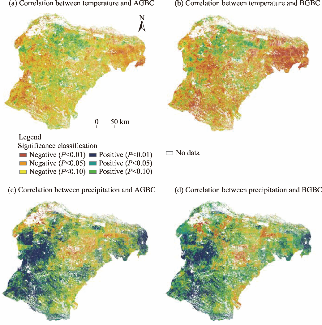
Grassland is a crucial component of the global ecosystem, essential for maintaining biodiversity, regulating climate, and stabilizing soil. The Mongolian Plateau, with its extensive grasslands, serves as a key region influencing the global carbon cycle. Therefore, accurately estimating above- and below-ground biomass carbon is critical. This study selects the Ordos Grassland on the Mongolian Plateau as a case study to evaluate the performance of five machine-learning models, including random forest (RF), support vector machine (SVM), decision tree (DT), k-nearest neighbors (KNN), and backpropagation neural network (BPNN), in predicting biomass carbon using key remote sensing variables as predictors. RF model exhibited excellent capability and stability in predicting both above-ground biomass carbon (AGBC) and below-ground biomass carbon (BGBC), outperforming SVM, DT, KNN, and BPNN models. The total AGBC and BGBC of Ordos Grassland were approximately 16.40×10⁵ and 83.88×10⁵ Mg C, respectively, with mean carbon densities of 116.94 and 575.44 g C/m2, respectively. Natural grasslands contributed 89.00% of the total carbon storage. Spatial analysis showed significant heterogeneity, with higher carbon storage values in the eastern region decreasing westward. Temporal analysis from 2019 to 2023 indicated that 36.00% of pixels showed increasing AGBC trends and 39.00% showed increasing BGBC trends. Climate correlation analysis revealed that precipitation was the primary controlling factor for AGBC through positive correlation, while temperature was the most significant factor affecting BGBC through negative correlation, with distinct spatial variations across different climatic conditions. These findings not only provide a scientific basis for the sustainable management of grassland ecosystems on the Mongolian Plateau, but also offer critical data support for regional carbon neutrality strategies and global climate change mitigation. Furthermore, the optimized machine-learning framework established in this study can be extended to large-scale grassland biomass carbon estimation in other similar ecosystems worldwide.
FAN Zhitao , DONG Fawu , LIU Dongwei , LI Bingjie , QU Zhicheng , YAO Shunyu , SU Xiashu , WANG Lixin . Estimates of grassland carbon storage using machine-learning models[J]. Regional Sustainability, 2026 , 7(3) : 100352 . DOI: 10.1016/j.regsus.2026.100352
| [1] | Altman, N.S., 1992. An introduction to Kernel and nearest-neighbor nonparametric regression. The American Statistician. 46(3), 175-185. |
| [2] | Bao, N.S., Li, W.W., Gu, X.W., et al., 2019. Biomass estimation for semiarid vegetation and mine rehabilitation using Worldview-3 and Sentinel-1 SAR imagery. Remote Sensing. 11(23), 2855, doi: 10.3390/rs11232855. |
| [3] | Braun, A., Wagner, J., Hochschild, V., 2018. Above-ground biomass estimates based on active and passive microwave sensor imagery in low-biomass savanna ecosystems. Journal of Applied Remote Sensing. 12(4), 046027, doi: 10.1117/1.JRS.12.046027. |
| [4] | Chapelle, O., Vapnik, V., Bousquet, O., et al., 2002. Choosing multiple parameters for support vector machines. Machine Learning. 46(1-3), 131-159. |
| [5] | Chou, J.S., Pham, A.D., 2017. Nature-inspired metaheuristic optimization in least squares support vector regression for obtaining bridge scour information. Information Sciences. 399, 64-80. |
| [6] | Chu, D., 2020. Aboveground biomass estimates of grassland in the North Tibet using MODIS remote sensing approaches. Applied Ecology and Environmental Research. 18(6), 7655-7672. |
| [7] | Cui, H.W., Wagg, C., Wang, X.T., et al., 2022. The loss of above- and belowground biodiversity in degraded grasslands drives the decline of ecosystem multifunctionality. Applied Soil Ecology. 172, 104370, doi: 10.1016/j.apsoil.2021.104370. |
| [8] | Dinc, M., Vatandaslar, C., Duman, A., et al., 2018. Estimating biomass and carbon storage of grasslands using very high-resolution satellite images in the Coruh River Basin (Northeastern Turkey). Fresenius Environmental Bulletin. 27(8), 5509-5519. |
| [9] | Ding, L., Li, Z.W., Shen, B.B., et al., 2022. Spatial patterns and driving factors of aboveground and belowground biomass over the eastern Eurasian steppe. Science of The Total Environment. 803(10), 149700, doi: 10.1016/j.scitotenv.2021.149700. |
| [10] | Dong, J.W., Tao, F., Zhang, G.L., 2011. Trends and variation in vegetation greenness related to geographic controls in middle and eastern Inner Mongolia, China. Environmental Earth Sciences. 62(2), 245-256. |
| [11] | Eisfelder, C., Klein, I., Bekkuliyeva, A., et al., 2017. Above-ground biomass estimation based on NPP time-series-A novel approach for biomass estimation in semi-arid Kazakhstan. Ecological Indicators. 72, 13-22. |
| [12] | Fang, J.Y., Guo, Z.D., Piao, S.L., et al., 2007. Terrestrial vegetation carbon sinks in China, 1981-2000. Science in China Series D: Earth Sciences. 50(9), 1341-1350. |
| [13] | Fang, J.Z., Xiong, K.N., Chi, Y.K., et al., 2022. Research advancement in grassland ecosystem vulnerability and ecological resilience and its inspiration for improving grassland ecosystem services in the karst desertification control. Plants. 11(10), 1290, doi: 10.3390/plants11101290. |
| [14] | Field, C.B., Campbell, J.E., Lobell, D.B., 2008. Biomass energy: the scale of the potential resource. Trends Ecology & Evolution. 23(2), 65-72. |
| [15] | Garroutte, E., Hansen, A., Lawrence, R., 2016. Using NDVI and EVI to map spatiotemporal variation in the biomass and quality of forage for migratory elk in the Greater Yellowstone Ecosystem. Remote Sensing. 8(5), 404, doi: 10.3390/rs0805404. |
| [16] | Ge, J., Hou, M.J., Liang, T.G., et al., 2022. Spatiotemporal dynamics of grassland aboveground biomass and its driving factors in North China over the past 20 years. Science of The Total Environment. 826(20), 154226, doi: 10.1016/j.scitotenv.2022.154226. |
| [17] | Geng, Y., Wang, Y.H., Yang, K., et al., 2012. Soil respiration in Tibetan alpine grasslands: belowground biomass and soil moisture, but not soil temperature, best explain the large-scale patterns. PLoS ONE. 7(4), e34968, doi: 10.1371/journal.pone.0034968. |
| [18] | Hastie, T., Tibshirani, R., Friedman, J., 2009. The Elements of Statistical Learning: Data Mining, Inference, and Prediction (2nd ed.). New York: Springer, 10-25. |
| [19] | Hernando, A., Puerto, L., Mola-Yudego, B., et al., 2019. Estimation of forest biomass components using airborne LiDAR and multispectral sensors. IForest - Biogeosciences and Forestry. 12(2), 207-213. |
| [20] | Hou, Q.Q., Ji, Z.X., Yang, H., et al., 2022. Impacts of climate change and human activities on different degraded grassland based on NDVI. Scientific Reports. 12(1), 15918, doi: 10.1038/s41598-022-19943-6. |
| [21] | Jia, W.X., Liu, M., Yang, Y.H., et al., 2016. Estimation and uncertainty analyses of grassland biomass in Northern China: Comparison of multiple remote sensing data sources and modeling approaches. Ecological Indicators. 60, 1031-1040. |
| [22] | John, R., Chen, J.Q., Kim, Y., et al., 2015. Differentiating anthropogenic modification and precipitation-driven change on vegetation productivity on the Mongolian Plateau. Landscape Ecology. 31(3), 547-566. |
| [23] | John, R., Chen, J.Q., Giannico, V., et al., 2018. Grassland canopy cover and aboveground biomass in Mongolia and Inner Mongolia: Spatiotemporal estimates and controlling factors. Remote Sensing of Environment. 213, 34-48. |
| [24] | Kang, L., Han, X.G., Zhang, Z.B., et al., 2007. Grassland ecosystems in China: review of current knowledge and research advancement. Philosophical Transactions of the Royal Society B. 362(1482), 997-1008. |
| [25] | Khan, K., Iqbal, J., Ali, A., et al., 2020. Assessment of Sentinel-2-derived vegetation indices for the estimation of above-ground biomass/carbon stock, temporal deforestation and carbon emissions estimation in the moist temperate forests of Pakistan. Applied Ecology and Environmental Research. 18(1), 783-815. |
| [26] | Koala, J., Sawadogo, L., Savadogo, P., et al., 2017. Allometric equations for below-ground biomass of four key woody species in West African savanna-woodlands. Silva Fennica. 51(3), 1631, doi: 10.14214/sf51031631. |
| [27] | Kong, D., Pang, Y., Li, B.W., 2026. Timber cruising data-driven forest biomass estimation model for airborne LiDAR point cloud. Geo-spatial Information Science. doi: 10.1080/10095020.2026.2613480. |
| [28] | Lee, W., Myung, K., 2002. Fuaay decision tree induction to obliquely partitioning a feature space. Journal of KIISE: Software and Applications. 29(4), 156-166. |
| [29] | Leonid, U., Yuriy, R., Vasiliy, U., et al., 2014. Impact of climate and grazing on biomass components of Eastern Russia typical steppe. Journal of Integrative Agriculture. 13(6), 1183-1192. |
| [30] | Li, C.H., Zhou, L.Z., Xu, W.B., 2021. Estimating aboveground biomass using Sentinel-2 MSI data and ensemble algorithms for grassland in the Shengjin Lake Wetland, China. Remote Sensing. 13(8), 1595, doi: 10.3390/rs13081595. |
| [31] | Li, F., Jiang, L., Wang, X.F., et al., 2013. Estimating grassland aboveground biomass using multitemporal MODIS data in the West Songnen Plain, China. Journal of Applied Remote Sensing. 7(1), 073546, doi: 10.1117/1.JRS.7.073546. |
| [32] | Li, F.Z., Zhong, H.P., Ouyang, K.H., et al., 2022. Estimation and mapping of actual and potential grassland root carbon storage: A case study in the Altay Region, China. Agronomy. 12(11), 2632, doi: 10.3390/agronomy12112632. |
| [33] | Li, H., Yang, B.H., Meng, Y., et al., 2023. Relationship between carbon pool changes and environmental changes in arid and semi-arid steppe-A two decades study in Inner Mongolia, China. Science of The Total Environment. 893, 164930, doi: 10.1016/j.scitotenv.2023.164930. |
| [34] | Li, H.Q., Li, F., Xiao, J.F., et al., 2024. A machine learning scheme for estimating fine-resolution grassland aboveground biomass over China with Sentinel-1/ 2 satellite images. Remote Sensing of Environment. 311, 114317, doi: 10.1016/j.rse.2024.114317. |
| [35] | Li, Q.H., Kelly, R., 2017. Correcting satellite passive microwave brightness temperatures in forested landscapes using satellite visible reflectance estimates of forest transmissivity. IEEE Journal of Selected Topics in Applied Earth Observations and Remote Sensing. 10(9), 3874-3883. |
| [36] | Liang, T.G., Yang, S.X., Feng, Q.S., et al., 2016. Multi-factor modeling of above-ground biomass in alpine grassland: A case study in the Three-River Headwaters Region, China. Remote Sensing of Environment. 186, 164-172. |
| [37] | Liu, M., Liu, G.H., Gong, L., et al., 2014. Relationships of biomass with environmental factors in the grassland area of Hulunbuir, China. PLoS ONE. 9(7), e102344, doi: 10.1371/journal.pone.0102344. |
| [38] | Lyu, X., Li, X.B., Gong, J.R., et al., 2021. Remote-sensing inversion method for aboveground biomass of typical steppe in Inner Mongolia, China. Ecological Indicators. 120, 106883, doi: 10.1016/j.ecolind.2020.106883. |
| [39] | Ma, C.Y., Liu, M.R., Liu, S.T., et al., 2023. Research review on methods of grassland health assessment. Chinese Journal of Applied Ecology. 34(12), 3427-3436 (in Chinese). |
| [40] | Ma, Q., Kuang, W.N., Liu, Z.M., et al., 2017. Spatial pattern of different component carbon in varied grasslands of northern China. Geoderma. 303, 27-36. |
| [41] | Ma, W.H., Fang, J.Y., Yang, Y.H., et al., 2010. Biomass carbon stocks and their changes in northern China’s grasslands during 1982-2006. Science China Life Sciences. 53(7), 841-850. |
| [42] | Maillard, É., McConkey, B.G., Angers, D.A., 2017. Increased uncertainty in soil carbon stock measurement with spatial scale and sampling profile depth in world grasslands: A systematic analysis. Agriculture, Ecosystems & Environment. 236, 268-276. |
| [43] | Meng, B.P., Gao, J.L., Liang, T.G., et al., 2018. Modeling of alpine grassland cover based on unmanned aerial vehicle technology and multi-factor methods: A case study in the east of Tibetan Plateau, China. Remote Sensing. 10, 320, doi: 10.3390/rs10020320. |
| [44] | Mokany, K., Raison, R.J., Prokushkin, A.S., 2006. Critical analysis of root: shoot ratios in terrestrial biomes. Global Change Biology. 12(1), 84-96. |
| [45] | Nandal, A., Yadav, S.S., Rao, A.S., et al., 2023. Advance methodological approaches for carbon stock estimation in forest ecosystems. Environmental Monitoring and Assessment. 195(2), 315, doi: 10.1007/s10661-022-10898-9. |
| [46] | Pan, T.L., Ye, H.P., Zhang, X.Y., et al., 2024. Estimating aboveground biomass of grassland in central Asia mountainous areas using unmanned aerial vehicle vegetation indices and image textures-A case study of typical grassland in Tajikistan. Environmental and Sustainability Indicators. 22, 100345, doi: 10.1016/j.indic.2024.100345. |
| [47] | Ping, X.Y., Zhou, G.S., Sun, J.S., 2010. Advances in the study of photosynthate allocation and its controls. Chinese Journal of Plant Ecology. 34(1), 100-111 (in Chinese). |
| [48] | Qian, Y., Tang, L.N., Qiu, Q.Y., et al., 2015. A comparative analysis on assessment of land carrying capacity with ecological footprint analysis and index system method. PLoS ONE. 10(6), e0130315, doi: 10.1371/journal.pone.0130315. |
| [49] | Rumelhart, D.E., Hinton, G.E., Williams, R.J., 1986. Learning representations by back-propagating errors. Nature. 323(6088), 533-536. |
| [50] | Salmeron-Gomez, R., Garcia-Garcia, C.B., Garcia-Perez, J., 2025. A redefined variance inflation factor: overcoming the limitations of the variance inflation factor. Computational Economics. 65(1), 337-363. |
| [51] | Seely, H., Coops, N.C., White, J.C., et al., 2026. Addressing the small data problem in forestry: self-supervised learning for aboveground biomass estimation. Forestry: An International Journal of Forest Research. 99(2), cpag004, doi: 10.1093/forestry/cpag004. |
| [52] | Song, J.W., 2015. Bias corrections for Random Forest in regression using residual rotation. Journal of the Korean Statistical Society. 44(2), 321-326. |
| [53] | Sun, J., Niu, S.L., Wang, J.N., 2018. Divergent biomass partitioning to aboveground and belowground across forests in China. Journal of Plant Ecology. 11(3), 484-492. |
| [54] | Tiscornia, G., Jaurena, M., Baethgen, W., 2019. Drivers, process, and consequences of native grassland degradation: Insights from a literature review and a survey in Río de la Plata Grasslands. Agronomy. 9(5), 239, doi: 10.3390/agronomy9050239. |
| [55] | Vapnik, V.N., 1995. The Nature of Statistical Learning Theory (1st ed.). New York: Springer, 1-18. |
| [56] | Viana, H., Aranha, J., Lopes, D., et al., 2012. Estimation of crown biomass of Pinus pinaster stands and shrubland above-ground biomass using forest inventory data, remotely sensed imagery and spatial prediction models. Ecological Modelling. 226, 22-35. |
| [57] | Wang, E., Huang, T.B., Liu, Z., et al., 2024. Improving forest above-ground biomass estimation accuracy using multi-source remote sensing and optimized least absolute shrinkage and selection operator variable selection method. Remote Sensing. 16(23), 4497, doi: 10.3390/rs16234497. |
| [58] | Wang, G.H., Li, H., An, M., et al., 2011. A regional-scale consideration of the effects of species richness on above-ground biomass in temperate natural grasslands of China. Journal of Vegetation Science. 22(3), 414-424. |
| [59] | Wang, K.B., Li, J.P., Shang, G.Z.P., 2012. Biomass components and environmental controls in Ningxia Grasslands. Journal of Integrative Agriculture. 11(12), 2079-2087. |
| [60] | Wang, R.C., Dong, J.J., Jin, L.S., et al., 2024. Improving the accuracy of vegetation index retrieval for biomass by combining Ground-UAV hyperspectral data-A new method for Inner Mongolia typical grasslands. Phyton-International Journal of Experimental Botany. 93(2), 387-411. |
| [61] | Wang, V., Gao, J., Schwendenmann, L., 2020. Assessing changes of urban vegetation cover and aboveground carbon stocks using LiDAR and Landsat imagery data in Auckland, New Zealand. International Journal of Remote Sensing. 41(6), 2140-2158. |
| [62] | Wang, Z.Y., Yi, L.B., Xu, W.Q., et al., 2023. Integration of UAV and GF-2 optical data for estimating aboveground biomass in spruce plantations in Qinghai, China. Sustainability. 15(12), 9700, doi: 10.3390/su15129700. |
| [63] | Wu, H.Q., An, S., Meng, B., et al., 2024. Retrieval of grassland aboveground biomass across three ecoregions in China during the past two decades using satellite remote sensing technology and machine learning algorithms. International Journal of Applied Earth Observation and Geoinformation. 130, 103925, doi: 10.1016/j.jag.2024.103925. |
| [64] | Wu, M.Q., Huang, W.J., Niu, Z., et al., 2017. Fine crop mapping by combining high spectral and high spatial resolution remote sensing data in complex heterogeneous areas. Computers and Electronics in Agriculture. 139, 1-9. |
| [65] | Wu, S.L., Wuda, E., Liu, Q.H., et al., 2023. The above- and below-ground biomass of alpine meadow on eastern margin of the Tibetan Plateau and their relationships with abiotic and biotic factors. Global Ecology and Conservation. 48, e02701, doi: 10.1016/j.gecco.2023.e02701. |
| [66] | Wu, Y., Li, F., Zhang, J., et al., 2024. Spatial and temporal patterns of above- and below- ground biomass over the Tibet Plateau grasslands and their sensitivity to climate change. Science of The Total Environment. 919, 170900, doi: 10.1016/j.scitotenv.2024.170900. |
| [67] | Xi, C., Cun, Z.L., Mao, W.L., et al., 2014. Seasonal dynamics of belowground biomass and productivity and potential of carbon sequestration in meadow steppe and typical steppe, in Inner Mongolia, China. Acta Ecologica Sinica. 34(19), 5530-5540 (in Chinese). |
| [68] | Xiao, C., Ji, Q.Y., Chen, J.Q., et al., 2023. Prediction of soil salinity parameters using machine learning models in an arid region of northwest China. Computers and Electronics in Agriculture. 204, 107512, doi: 10.1016/j.compag.2022.107512. |
| [69] | Xing, H.Q., Zhang, Y.Q., Zhu, L.Y., et al., 2024. MSAVI-enhanced CASA model for estimating the carbon sink in coastal wetland area: a case study of Shandong Province. IEEE Journal of Selected Topics in Applied Earth Observations and Remote Sensing. 17, 19698-19712. |
| [70] | Yang, S.X., Feng, Q.S., Liang, T.G., et al., 2018. Modeling grassland above-ground biomass based on artificial neural network and remote sensing in the Three-River Headwaters Region. Remote Sensing of Environment. 204, 448-455. |
| [71] | Yang, Y., Dou, Y.X., An, S.S., 2017. Environmental driving factors affecting plant biomass in natural grassland in the Loess Plateau, China. Ecological Indicators. 82, 250-259. |
| [72] | Yu, R.Y., Yao, Y.J., Wang, Q., et al., 2021. Satellite-derived estimation of grassland aboveground biomass in the Three-River Headwaters Region of China during 1982-2018. Remote Sensing. 13(15), 2993, doi: 10.3390/rs13152993. |
| [73] | Yuan, H.H., Yang, G.J., Li, C.C., et al., 2017. Retrieving soybean leaf area index from unmanned aerial vehicle hyperspectral remote sensing: Analysis of RF, ANN, and SVM regression models. Remote Sensing. 9(4), 309, doi: 10.3390/rs9040309. |
| [74] | Yuan, X.L., Li, L.H., Tian, X., et al., 2016. Estimation of above-ground biomass using MODIS satellite imagery of multiple land-cover types in China. Remote Sensing Letters. 7(12), 1141-1149. |
| [75] | Zhang, B.H., Zhang, L., Xie, D., et al., 2015. Application of synthetic NDVI time series blended from Landsat and MODIS data for grassland biomass estimation. Remote Sensing. 8(1), 10, doi: 10.3390/rs8010010. |
| [76] | Zhang, C., Lu, D.S., Chen, X., et al., 2016. The spatiotemporal patterns of vegetation coverage and biomass of the temperate deserts in Central Asia and their relationships with climate controls. Remote Sensing of Environment. 175, 271-281. |
| [77] | Zhang, H.P., Wang, M.H., 2009. Search for the smallest random forest. Statistics and Its Interface. 2(3), 381-388. |
| [78] | Zhang, J.R., Xiao, J.F., Tong, X.J., et al., 2024. Comparing the performance of phenocam GCC, MODIS GCC, and MODIS EVI for retrieving vegetation phenology and estimating gross primary production. Ecological Indicators. 166, 112251, doi: 10.1016/j.ecolind.2024.112251. |
| [79] | Zhang, M., Wu, B.F., Zeng, H.W., et al., 2021. GCI30: a global dataset of 30 m cropping intensity using multisource remote sensing imagery. Earth System Science Data. 13(10), 4799-4817. |
| [80] | Zhang, R.P., Zhou, J.H., Guo, J., et al., 2023a. Inversion models of aboveground grassland biomass in Xinjiang based on multisource data. Frontiers in Plant Science. 14, 1152432, doi: 10.3389/fpls.2023.1152432. |
| [81] | Zhang, R.Q., Feng, Q.S., Zhang, Y.H., et al., 2025. Estimation and trend analysis of grassland aboveground biomass on the Qinghai-Xizang Plateau based on machine learning. Ecological Indicators. 177, 113715, doi: 10.1016/j.ecolind.2025.113715. |
| [82] | Zhang, Y.J., Zhou, T., Liu, X., et al., 2023b. Crucial roles of the optimal time-scale of water condition on grassland biomass estimation on Qinghai-Tibet Plateau. Science of The Total Environment. 905, 167210, doi: 10.1016/j.scitotenv.2023.167210. |
| [83] | Zhao, F., Xu, B., Yang, X.C., et al., 2014. Remote sensing estimates of grassland aboveground biomass based on MODIS Net Primary Productivity (NPP): A case study in the Xilingol Grassland of northern China. Remote Sensing. 6(6), 5368-5386. |
| [84] | Zheng, L., Zhao, G.S., Dong, J.W., et al., 2019. Spatial, temporal, and spectral variations in albedo due to vegetation changes in China’s grasslands. ISPRS Journal of Photogrammetry and Remote Sensing. 152, 1-12. |
| [85] | Zhong, G.R., Chen, J.J., Huang, R.J., et al., 2023. High spatial resolution fractional vegetation coverage inversion based on UAV and Sentinel-2 data: A case study of Alpine Grassland. Remote Sensing. 15(17), 4266, doi: 10.3390/rs15174266. |
/
| 〈 |
|
〉 |
 REGSUS Wechat
 新公网安备 65010402001202号