

Understanding the spatiotemporal patterns of nighttime urban vibrancy in central Shanghai inferred from mobile phone data
Received date: 2021-04-16
Revised date: 2021-09-22
Accepted date: 2021-11-10
Online published: 2022-03-18
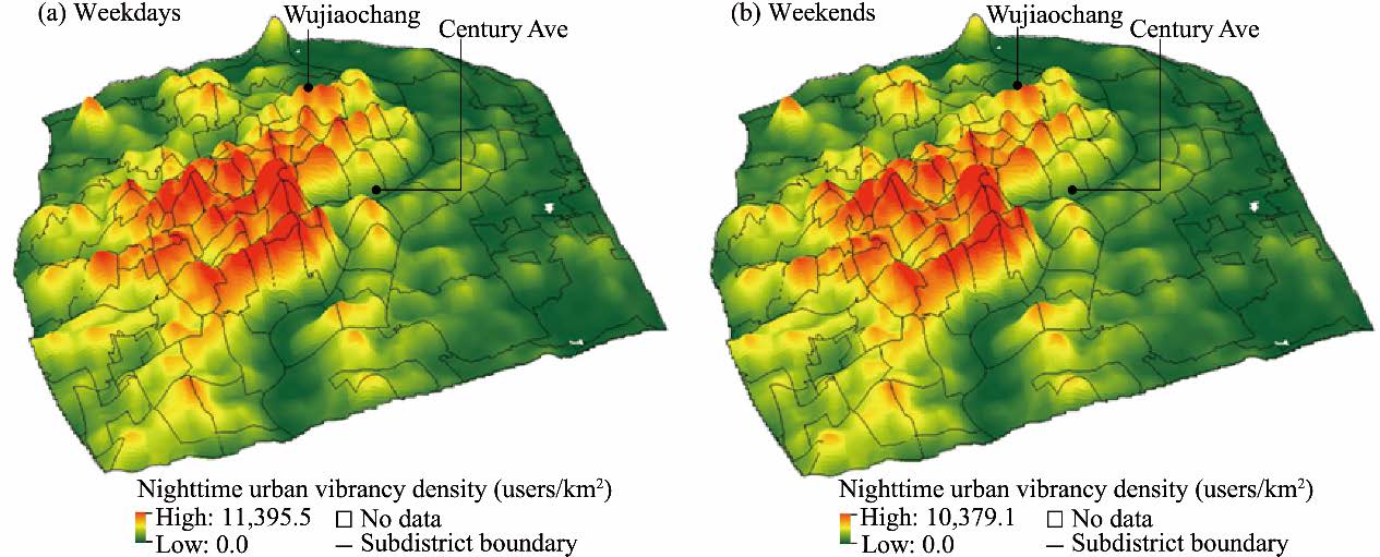
In recent years, major cities around the world such as New York in USA, Melbourne in Australia, and Shanghai in China, have planned to boost their nighttime urban vibrancy levels to spur the economy and achieve cultural diversity. The study of nighttime urban vibrancy from the perspective of spatiotemporal characteristics is increasingly being recognized as part of the essential work in the field of urban planning and geography. This research used mobile phone signaling records to measure urban vibrancy in central Shanghai and revealed its spatiotemporal patterns during nighttime. Specifically, this research explored the changes of urban vibrancy within a day, studied the distribution of urban vibrancy during the nighttime, and visually presented the spatiotemporal changes of nighttime urban vibrancy in central Shanghai. Moreover, on the basis of the behavior pattern of each mobile user, we classified nighttime urban vibrancy into three different types: nighttime working vibrancy, nighttime leisure vibrancy, and nighttime floating vibrancy. We then tried to determine how land use affected nighttime leisure vibrancy. The results showed that urban vibrancy in central Shanghai exhibits a periodic pattern over one-day period. A high-level nighttime urban vibrancy belt is present within central Shanghai. Business offices, hotels, entertainment and recreational districts, wholesale markets, and express services contribute most to the vibrancy at nighttime. In addition, the correlation analysis shows that public and commercial facilities generate high levels of nighttime leisure vibrancy than residential facilities. The mixed land use of public and commercial facilities and residential facilities within 500 m is more critical than the mixed use of a single land lot. The research can be a basis for supporting land use planning and providing evidence for policy-making to improve the level of nighttime urban vibrancy in cities.
ZHANG Yangfan , ZHONG Weijing , WANG De , LIN Feng-Tyan . Understanding the spatiotemporal patterns of nighttime urban vibrancy in central Shanghai inferred from mobile phone data[J]. Regional Sustainability, 2021 , 2(4) : 297 -307 . DOI: 10.1016/j.regsus.2021.11.006
| [1] | Chion, M., 2009. Producing urban vitality: the case of dance in San Francisco. Urban Geogr. 30(4), 416-439. |
| [2] | Diplomacy, S., Seijas, A., 2021. A Guide to Managing Your Night Time Economy. [2021-12-18]. https://www.sounddiplomacy.com/night-time-economy-guide. |
| [3] | Greater London, Authority, 2019. Cultural Infrastructure Plan: A Call to Action. London: Greater London Authority, City Hall, The Queen’s Walk, More London, and London SE1 2AA. [2021-05-06]. https://www.london.gov.uk/sites/default/files/cultural_infrastructure_plan_online.pdf. |
| [4] | Jacobs, J., 1961. The Death and Life of Great American Cities. New York: Random House. |
| [5] | Jang, W.J., 2010. Travel time and transfer analysis using transit smart card data. Transp. Res. Record. 2144(1), 142-149. |
| [6] | Jiang, S., Ferreira, J.Jr., Gonzalez, M.C., 2017. Activity-based human mobility patterns inferred from mobile phone data: a case study of Singapore. IEEE Trans. Big Data. 3(2), 208-219. |
| [7] | Lunecke, M.G.H., Mora, R., 2018. The layered city: pedestrian networks in downtown Santiago and their impact on urban vitality. J.Urban Des. 23(3), 336-353. |
| [8] | Luo, S.Z.X., Zhen, F., 2019. How to evaluate public space vitality based on mobile phone data: an empirical analysis of Nanjing’s parks. Geographical Research. 38(7), 1594-1608 (in Chinese). |
| [9] | Maas, P.R., 1984. Towards a Theory of Urban Vitality. Vancouver: University of British Columbia. [2021-05-06]. https://open.library.ubc.ca/soa/cIRcle/collections/ubctheses/831/items/1. 0096212. |
| [10] | National Bureau of Statistics of the People’s Republic of China, 2010. Sixth National Population Census of the People’s Republic of China. [2021-03-08]. https://infogalactic.com/info/Sixth_National_Population_Census_of_the_People%27s_Republic_of_China. |
| [11] | Ning, X.P., 2016. The impact analysis of land use structure and urban vibrancy. Msc Thesis. Shenzhen: Shenzhen University (in Chinese). |
| [12] | Niu, X.Y., Ding, L., Song, X.D., 2015. Understanding urban spatial structure of Shanghai central city based on mobile phone data. China City Planning Review. 24(3), 15-23 (in Chinese). |
| [13] | Population Division of Department of Economic and Social Affairs of the United Nations, 2018. 2018 Revision of World Urbanization Prospects. [2021-05-12]. https://population.un.org/wup/. |
| [14] | Rahimi, S., Mottahedi, S., Liu, X., 2018. The geography of taste: using yelp to study urban culture. ISPRS Int. Geo-Inf. 7(9), 376, doi: 10.3390/ijgi7090376. |
| [15] | Ratti, C., Frenchman, D., Pulselli, R.M., et al., 2006. Mobile landscapes: using location data from cell phones for urban analysis. Environment and Planning B: Urban Analytics and City Science. 33(5), 727-748. |
| [16] | Sedaghati, A., Farsi, J., 2016. Vitality spectrography in urban textures and neighborhoods by integrating sustainable development, smart growth and new urbanism approaches and use of electre model (Case study: Marvdasht’s neighborhoods). Geography and Development. 14(44), 229-253. |
| [17] | Still, B., Simmonds, D., 2000. Parking restraint policy and urban vitality. Transp. Rev. 20(3), 291-316. |
| [18] | Xie, D.C., Wang, D., Zhong, W.J., et al., 2018. Assessment and analysis on built environment of shanghai: an exploration based on mobile phone signaling data. City Planning Review, 42(10), 97-108, 120 (in Chinese). |
| [19] | Yan, L.X., Wang, D., Zhang, S.W., et al., 2019. Evaluating the multi-scale patterns of jobs-residence balance and commuting time-cost using cellular signaling data: a case study in Shanghai. Transportation. 46, 777-792. |
| [20] | Zhen, F., Cao, Y., Qin, X., et al., 2017. Delineation of an urban agglomeration boundary based on Sina Weibo microblog ‘check-in’ data: A case study of the Yangtze River Delta. Cities. 60, 180-191. |
| [21] | Zhou, J.B., Pei, H.B., Wu, H.S., 2018. Early warning of human crowds based on query data from Baidu maps: analysis based on Shanghai stampede. In: Shen, Z.J., Li, M.Y., (eds.). Big Data Support of Urban Planning and Management. Cham:Springer, 19-41. |
/
| 〈 |
|
〉 |
 REGSUS Wechat
 新公网安备 65010402001202号