Regional Sustainability ›› 2021, Vol. 2 ›› Issue (3): 264-279.doi: 10.1016/j.regsus.2021.11.005cstr: 32279.14.j.regsus.2021.11.005
• Full Length Article • Previous Articles Next Articles
WANG Jiea, LIU Dongweia,b,c,*( ), TIAN Songnia, HU Yuehonga, MA Jialia, WANG Lixina,b,c
Received:2021-07-24
Revised:2021-10-16
Accepted:2021-11-10
Published:2021-07-30
Online:2021-12-24
Contact:
LIU Dongwei
E-mail:liudw@imu.edu.cn
WANG Jie, LIU Dongwei, TIAN Songni, HU Yuehong, MA Jiali, WANG Lixin. Coupling analysis of short-term weather and runoff in an arid lake basin of China[J]. Regional Sustainability, 2021, 2(3): 264-279.
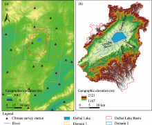
Fig. 1.
Overview of the study area (a) and geographic elevation and river distribution in the Daihai Lake Basin (b)."

Table 1
Basic settings for Weather Research and Forecasting model (WRF) and Weather Research and Forecasting model mode-Hydrological module (WRF-HYDRO)."
| Parameter | Setting | |
|---|---|---|
| Domain 1 | Domain 2 | |
| Domain horizontal resolution (km) | 3 | 1 |
| Domain center | 40°30′34.3′′N, 112°38′45.5′′E | 40°30′34.3′′N, 112°38′45.5′′E |
| Number of horizontal grids in the domain | 40×60 | 64×82 |
| Scale | 3:1 | 3:1 |
| Vertical layers | 38 | 38 |
| Pressure of top layer (kPa) | 5 | 5 |
| Integration time step (s) | 30 | 30 |
| Output time step (h) | 6 | 6 |
Table 2
Physical parameters used in WRF."
| Parameter | Scheme selection | Basic significance |
|---|---|---|
| Microphysics scheme (mp_physics) | 2, Purdue Lin scheme ( | Suitable for high resolution simulation of real data |
| Longwave radiation (ra_lw_physics) | 1, Rapid Radiative Transfer Mode (RRTM) scheme (Eli et al., 1997) | Fast radiative transfer model with accurate solution using lookup tables to improve efficiency |
| Shortwave radiation (ra_sw_physics) | 1, Dudhia scheme ( | Simple downward integration can effectively absorb and scatter clouds and clear skies |
| Land surface scheme (sf_surface_physics) | 2, Noah ( | Four layers of soil temperature and moisture, partial snow, and frozen soil physical properties |
| Lake physics (sf_lake_physics) | 1, Common Land Model 4.5 (CLM4.5) lake model | The lake scheme comes from CLM4.5 |
| Planetary boundary layer (bl_pbl_physics) | 1, Yonsei University scheme ( | An explicit inclusion layer and a parabolic K-shape nonlocal K-scheme are presented in the unstable mixing layer |
| Cumulus parameterization (cu_physics) | 1, Kain-Fritsch scheme | Shallow and deep convective sub-grid scheme using mass flux method |
Table 3
Basic setup for the online coupling WRF-HYDRO."
| Parameter | Setting |
|---|---|
| Hydro output interval (h) | 6 |
| Surface model | Noah |
| Re-interpolation factor | 10:1 |
| Depth of soil column (m) | 2 |
| Thickness of soil layer (cm) | 10, 30, 60, and 100 |
| Built in resolution (m) | 100 |
| Model time step (s) | 10 |
| Subsurface routing (SUBRTSWCRT) | 1, Yes |
| Overland flow routing (OVRTSWCRT) | 1, Yes |
| Channel routing (CHANRTSWCRT, channel_option) | 1, Yes; 3, with diffusive wave |
| Baseflow bucket model (GWBASESWCRT) | 0, No |
Table 4
Calibration parameters and their setting values in WRF-HYDRO."
| Parameter classification | Parameter | Setting value |
|---|---|---|
| Global parameters | REFKDT | 1.0, 2.0, 2.5, 3.0, 3.5, and 4.0 |
| MannN | 1.0, 1.2, 1.5, 1.8, and 2.0 | |
| Local parameters | RETDEPRTFAC | 0.1, 1.0, and 1.5 |
| OVROUGHRTFAC | 0.1, 1.0, and 1.5 |
Table 5
Details of the selected two rainstorm events in the history of the Daihai Lake Basin."
| Event | Weather station | Start time (UTC) | End time (UTC) |
|---|---|---|---|
| Storm I | Liangcheng County in Inner Mongolia Autonomous Region | At 00:00 on 1 August 2015 | At 19:00 on 1 August 2015 |
| Storm II | Liangcheng County in Inner Mongolia Autonomous Region | At 03:00 on 25 July 2020 | At 19:00 on 25 July 2020 |
Table 6
Simulation settings of the selected two rainstorm events in the Daihai Lake Basin."
| Event | Storm I | Storm II |
|---|---|---|
| Simulation start time (UTC) | At 18:00 on 31 July 2015 | At 18:00 on 24 July 2020 |
| Simulation end time (UTC) | At 00:00 on 2 August 2015 | At 00:00 on 27 July 2020 |
| Output time step (h) | 1 | 1 |
| Static database using land use | MOD12Q1 2015 | MOD12Q1 2020 |
| Static database using leaf area index | MOD15A1 201507 | MOD15A1 202007 |
Table 7
Classification criteria of soil types in Soil Conservation Service Curve Number (SCS-CN) model."
| Soil type | Minimum infiltration rate (%) | Soil texture |
|---|---|---|
| A | >7.26 | Sandy soil, loamy sandy soil, and sandy loam |
| B | 3.81-7.26 | Loam and silt loam |
| C | 1.27-3.81 | Sandy clay loam |
| D | <1.27 | Clay loam, silty clay loam, sandy clay, silty clay, and clay |
Table 8
Classification criteria of soil moisture degree in SCS-CN model."
| Soil moisture classification | Rainfall in the five days before the rainfall event (mm) | |
|---|---|---|
| Crop growth stage | Non crop growth stage | |
| Dry (AMC I) | <30.0 | <15.0 |
| Average (AMC II) | 30.0-50.0 | 15.0-30.0 |
| Wet (AMC III) | >50.0 | >30.0 |

Fig. 2.
Surface runoff curves with different parameter values: surface runoff curves with different values of runoff infiltration parameter (REFKDT) in 2018 (a); surface runoff curves with different values of surface retention depth scaling parameter (RETDEPRTFAC) in 2018 (b); surface runoff curves with different values of overland flow roughness scaling parameter (OVROUGHRTFAC) in 2018 (c); and surface runoff curves with different values of channel Manning roughness parameter (MannN) in 2018 (d). SCS-CN, Soil Conservation Service Curve Number."
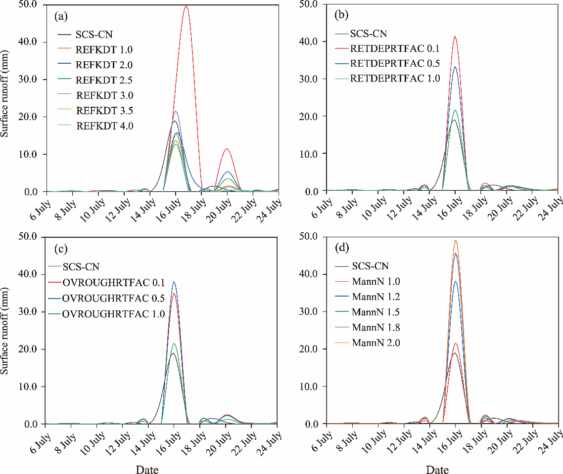
Table 9
Evaluation results of different physics parameters."
| Parameter | Value | RMSE | PBIAS (%) | NSE | R |
|---|---|---|---|---|---|
| REFKDT | 1.0 | 11.15 | 198.92 | -5.54 | 0.49 |
| 2.0 | 2.34 | -4.79 | 0.71 | 0.84 | |
| 2.5 | 1.95 | -28.42 | 0.80 | 0.91 | |
| 3.0 | 1.79 | -18.56 | 0.83 | 0.93 | |
| 3.5 | 2.09 | -46.78 | 0.77 | 0.92 | |
| 4.0 | 2.20 | -54.02 | 0.74 | 0.93 | |
| RETDEPRTFAC | 0.1 | 5.43 | 58.51 | -0.55 | 0.93 |
| 0.5 | 3.70 | 13.85 | 0.28 | 0.93 | |
| 1.0 | 1.79 | -18.56 | 0.83 | 0.93 | |
| OVROUGHRTFAC | 0.1 | 4.10 | 37.13 | 0.12 | 0.93 |
| 0.5 | 4.73 | 31.56 | -0.18 | 0.93 | |
| 1.0 | 1.79 | -18.56 | 0.83 | 0.93 | |
| MannN | 1.0 | 1.40 | -0.18 | 0.83 | 0.93 |
| 1.2 | 3.71 | 0.38 | -0.18 | 0.93 | |
| 1.5 | 4.95 | 0.64 | -1.10 | 0.93 | |
| 1.8 | 5.03 | 0.68 | -1.17 | 0.93 | |
| 2.0 | 5.62 | 0.81 | -1.71 | 0.93 |
Table 10
Initial conditions of the river channel."
| River grade | BW (m) | Hlink (m) | ChSSlp (m/m) | MannN |
|---|---|---|---|---|
| 1 | 1.5 | 0.02 | 3.00 | 0.55 |
| 2 | 3.0 | 0.02 | 1.00 | 0.35 |
| 3 | 5.0 | 0.02 | 0.50 | 0.15 |
| 4 | 10.0 | 0.03 | 0.18 | 0.10 |
| 5 | 20.0 | 0.03 | 0.05 | 0.07 |
| 6 | 40.0 | 0.03 | 0.05 | 0.05 |
| 7 | 60.0 | 0.03 | 0.05 | 0.04 |
| 8 | 70.0 | 0.10 | 0.05 | 0.03 |
| 9 | 80.0 | 0.30 | 0.05 | 0.02 |
| 10 | 100.0 | 0.30 | 0.05 | 0.01 |
Fig. 3.
Comparison of simulated and observed rainfall and surface runoff for Storm I in 2015 (a) and Storm II in 2020 (b). Rainfall R, correlation coefficient between simulated rainfall and observed rainfall; Runoff R, correlation coefficient between simulated runoff and observed runoff."
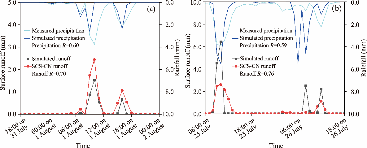
Table 11
Evaluation indices of runoff simulation accuracy in the selected two rainstorm events."
| Event | R | PBIAS (%) | RMSE | NSE |
|---|---|---|---|---|
| Storm I | 0.70 | -50.15 | 0.28 | 0.38 |
| Storm II | 0.76 | 34.04 | 0.77 | 0.52 |
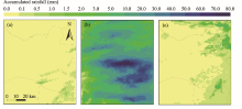
Fig. 4.
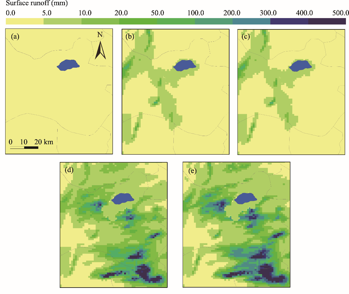
Spatial distribution of rainfall simulation in Storm I. (a), accumulated rainfall from 18:00 on 31 July 2015 to 00:00 on 1 August 2015; (b), accumulated rainfall from 00:00 on 1 August 2015 to 12:00 on 1 August 2015; (c), accumulated rainfall from 12:00 on 1 August 2015 to 00:00 on 2 August 2015."


Fig. 5.
Spatial distribution of simulated surface runoff (mm/6 h) in Storm I. (a), surface runoff from 18:00 on 31 July 2015 to 00:00 on 1 August 2015; (b), surface runoff from 00:00 on 1 August 2015 to 12:00 on 1 August 2015; (c), surface runoff from 12:00 on 1 August 2015 to 00:00 on 2 August 2015."
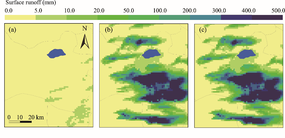

Fig. 6.
Spatial distribution of accumulated rainfall for Storm II. (a), accumulated rainfall from 00:00 on 25 July 2020 to 12:00 on 25 July 2020; (b), accumulated rainfall from 12:00 on 25 July 2020 to 00:00 on 26 July 2020; (c), accumulated rainfall from 00:00 on 26 July 2020 to 12:00 on 26 July 2020; (d), accumulated rainfall from 12:00 on 26 July 2020 to 00:00 on 27 July 2020; (e), accumulated rainfall from 00:00 on 27 July 2020 to 12:00 on 27 July 2020."
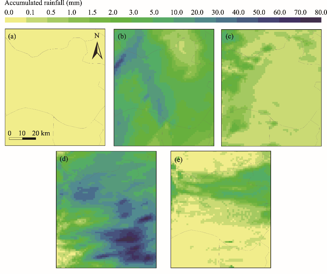

Fig. 7.
Spatial distribution of simulated surface runoff (mm/6 h) for Storm II. (a), surface runoff from 00:00 on 25 July 2020 to 12:00 on 25 July 2020; (b), surface runoff from 12:00 on 25 July 2020 to 00:00 on 26 July 2020; (c), surface runoff from 00:00 on 26 July 2020 to 12:00 on 26 July 2020; (d), surface runoff from 12:00 on 26 July 2020 to 00:00 on 27 July 2020; (e), surface runoff from 00:00 on 27 July 2020 to 12:00 on 27 July 2020."
| [1] | Abula, A., Wang, Y., Ling, H., et al., 2019. Analysis of water resources change trend and water use efficiency in Tarim River Basin. Journal of Shihezi University (Natural Science). 37(1), 112-120 (in Chinese). |
| [2] |
Al-Ghobari, H., Dewidar, A., 2021. Integrating GIS-based MCDA techniques and the SCS-CN method for identifying potential zones for rainwater harvesting in a semi-arid area. Water. 13(5), 704.
doi: 10.3390/w13050704 |
| [3] |
Chao, L.J., Zhang, K., Yang, Z.L., et al., 2021. Improving flood simulation capability of the WRF-Hydro-RAPID model using a multi-source precipitation merging method. J. Hydrol. 592, 125814.
doi: 10.1016/j.jhydrol.2020.125814 |
| [4] |
Chen, J.Q., Lv, J., Li, N., et al., 2019. External groundwater alleviates the degradation of closed lakes in semi-arid regions of China. Remote. Sens. 12(1), 1-20.
doi: 10.3390/rs12010001 |
| [5] | Chen, J.S., Ji, B.C., Liu, Z., et al., 2013. Isotopic and hydro-chemical evidence on the origin of groundwater through deep-circulation ways in Lake Daihai region, Inner Mongolia plateau. J. Lake Sci. 25(4), 521-530. |
| [6] | Darji, K., Prakash, I., Pham, B., 2020. Runoff estimation of machhu and watrak rivers basins of gujarat India using SCS-CN method and GIS. Indian J. Ecol. 47(3), 726-732. |
| [7] |
Dudhia, J., 1989. Numerical study of convection observed during the winter monsoon experiment using a mesoscale two-dimensional model. J. Atmos. Sci. 46(20), 3077-3107.
doi: 10.1175/1520-0469(1989)046<3077:NSOCOD>2.0.CO;2 |
| [8] | Gochis, D., Yu, W., Yates, D., 2013. The NCAR WRF-Hydro Technical Description and User’s Guide (Version 1.0). Boulder: NCAR. |
| [9] | Hao, W., Qin, D.Y., Wang, J.H., et al., 2004. Study on water resources carrying capacity in northwest inland arid area in China. J. Nat. Resour. 19(2), 151-159. |
| [10] |
Hong, S.Y., Noh, Y., Dudhia, J., 2006. A new vertical diffusion package with an explicit treatment of entrainment processes. Mon. Weather Rev. 134(9), 2318.
doi: 10.1175/MWR3199.1 |
| [11] | Hu, L., Lu, W., 2014. Analysis on water environment status and necessity of water supplement in Daihai basin of Liangcheng County. Inner Mongolia Water Resources. 1, 109-110 (in Chinese). |
| [12] |
Lahmers, T.M., Gupta, H., Castro, C.L., et al., 2019. Enhancing the structure of the WRF-hydro hydrologic model for semiarid environments. J. Hydrometeorol. 20(4), 691-714.
doi: 10.1175/JHM-D-18-0064.1 |
| [13] |
Lin, Y.L., Farley, R.D., Orville, H.D., 1983. Bulk parameterization of the snow field in a cloud model. J. Climate Appl. Meteor. 22(6), 1065-1092.
doi: 10.1175/1520-0450(1983)022<1065:BPOTSF>2.0.CO;2 |
| [14] |
Liu, J., Bray, M., Han, D.W., 2013. Exploring the effect of data assimilation by WRF-3DVar for numerical rainfall prediction with different types of storm events. Hydrol. Process. 27(25), 3627-3640.
doi: 10.1002/hyp.v27.25 |
| [15] | Liu, Y.C., Liu, J., Li, C.Z., et al., 2019. Advances of WRF-hydro and its application in hydrological simulation and forecasting. Water Resources and Power. 37(11), 1-5 (in Chinese). |
| [16] |
Liu, Y.C., Liu, J., Li, C.Z., et al., 2021. Parameter sensitivity analysis of the WRF-hydro modeling system for streamflow simulation: a case study in semi-humid and semi-arid catchments of Northern China. Asia Pac. J. Atmos. Sci. 57(3), 451-466.
doi: 10.1007/s13143-020-00205-2 |
| [17] |
Liu, Z.H., Xu, J.H., Chen, Z.S., et al., 2014. Multifractal and long memory of humidity process in the Tarim River Basin. Stoch. Environ. Res. Risk Assess. 28(6), 1383-1400.
doi: 10.1007/s00477-013-0832-9 |
| [18] |
Mahmood, K., Qaiser, A., Farooq, S., et al., 2020. RS- and GIS-based modeling for optimum site selection in rain water harvesting system: an SCS-CN approach. Acta Geophys. 68(4), 1175-1185.
doi: 10.1007/s11600-020-00460-x |
| [19] | Meng, X.Y., Meng, B.C., Wang, Y.J., et al., 2015. Influence of climate change and human activities on water resources in ebinur lake in recent 60 years. J. China Hydrol. 35(2), 90-96. |
| [20] |
Mlawer, E.J., Taubman, S.J., Brown, P.D., et al., 1997. Radiative transfer for inhomogeneous atmospheres: RRTM, a validated correlated-k model for the longwave. J. Geophys. Res. Atmos. 102(D14), 16663-16682.
doi: 10.1029/97JD00237 |
| [21] | Naabil, E., Lamptey, B.L., Arnault, J., et al., 2017. Water resources management using the WRF-Hydro modelling system: case-study of the Tono Dam in West Africa. J. Hydrol. Reg. Stud. 12, 196-209. |
| [22] | Qiao, P., Qin, Y., Liu, Z.H., 2011. A spatially distributed snowmelt model based on energy balance. J. China Hydrol. 31(3), 22-26. |
| [23] |
Reda, K.W., Liu, X.C., Tang, Q.H., et al., 2021. Evaluation of global gridded precipitation and temperature datasets against gauged observations over the upper tekeze river basin, Ethiopia. J. Meteorol. Res. 35(4), 673-689.
doi: 10.1007/s13351-021-0199-7 |
| [24] |
Rummler, T., Arnault, J., Gochis, D., et al., 2019. Role of lateral terrestrial water flow on the regional water cycle in a complex terrain region: investigation with a fully coupled model system. J. Geophys. Res. Atmos. 124(2), 507-529.
doi: 10.1029/2018JD029004 |
| [25] |
Silver, M., Karnieli, A., Ginat, H., et al., 2017. An innovative method for determining hydrological calibration parameters for the WRF-Hydro model in arid regions. Environ. Model. Softw. 91, 47-69.
doi: 10.1016/j.envsoft.2017.01.010 |
| [26] | Sun, M.K., Li, Z.J., Liu, Z.Y., et al., 2020a. Application of WRF-Hydro modeling system in Chenhe Basin and comparison with Xin’anjiang model. J. Lake Sci. 32(3), 850-864. |
| [27] |
Sun, M.K., Li, Z.J., Yao, C., et al., 2020b. Evaluation of flood prediction capability of the WRF-hydro model based on multiple forcing scenarios. Water. 12(3), 874.
doi: 10.3390/w12030874 |
| [28] |
Tian, J.Y., Liu, J., Yan, D.H., et al., 2019. Ensemble flood forecasting based on a coupled atmospheric-hydrological modeling system with data assimilation. Atmos. Res. 224, 127-137.
doi: 10.1016/j.atmosres.2019.03.029 |
| [29] | Wang, M., He, X., Guo, H., 2020. Influence of land use data resolution on SCS model in runoff simulation. Pearl River. 41(10), 30-35 (in Chinese). |
| [30] | Wang, S.H., Bai, M.X., Chen, J.Y., et al., 2019. Research on the ecological protection and restoration of mountain-river-forest-farmland-lake-grassland system in typical farming-pastoral ecotone: taking Daihai Lake Basin in Inner Mongolia as an example. Journal of Environmental Engineering Technology. 9(5), 515-519 (in Chinese). |
| [31] | Wang, Y.J., Qin, D.H., 2017. Influence of climate change and human activity on water resources in arid region of Northwest China: an overview. Adv. Clim. Change Res. 8(4), 268-278. |
| [32] |
Wehbe, Y., Temimi, M., Weston, M., et al., 2019. Analysis of an extreme weather event in a hyper-arid region using WRF-Hydro coupling, station, and satellite data. Nat. Hazards Earth Syst. Sci. 19(6), 1129-1149.
doi: 10.5194/nhess-19-1129-2019 |
| [33] |
Xiao, B., Wang, Q.H., Fan, J., et al., 2011. Application of the SCS-CN model to runoff estimation in a small watershed with high spatial heterogeneity. Pedosphere. 21(6), 738-749.
doi: 10.1016/S1002-0160(11)60177-X |
| [34] |
Yang, M., Sun, X.H., 2011. Research on SCS-CN in Lanhe Basin distributed rainfall runoff event. Appl. Mech. Mater. 105-107, 1476-1479.
doi: 10.4028/www.scientific.net/AMM.105-107 |
| [35] |
Yucel, I., Onen, A., Yilmaz, K.K., et al., 2015. Calibration and evaluation of a flood forecasting system: utility of numerical weather prediction model, data assimilation and satellite-based rainfall. J. Hydrol. 523, 49-66.
doi: 10.1016/j.jhydrol.2015.01.042 |
| [36] | Yun, M., Yan, S., Gong, J., 2019. Analysis of inflow runoff in Daihai. Inner Mongolia Water Resources. (5), 21-22 (in Chinese). |
| [37] |
Zhang, Z.Y., Arnault, J., Wagner, S., et al., 2019. Impact of lateral terrestrial water flow on land-atmosphere interactions in the Heihe River basin in China: fully coupled modeling and precipitation recycling analysis. J. Geophys. Res. Atmos. 124(15), 8401-8423.
doi: 10.1029/2018JD030174 |
| [38] | Zhou, X., Wang, Q., Zhang, D., et al., 2021. Runoff estimation of ridge-furrow rainwater harvesting with maize straw biochar application based on soil conservation service curve number (SCS-CN) model in semiarid regions of China. Arid Land Geography. 44(1), 99-108 (in Chinese). |
| No related articles found! |
| Viewed | ||||||
|
Full text |
|
|||||
|
Abstract |
|
|||||
 REGSUS Wechat
 新公网安备 65010402001202号