Regional Sustainability ›› 2025, Vol. 6 ›› Issue (1): 100197.doi: 10.1016/j.regsus.2025.100197cstr: 32279.14.REGSUS.2025005
• Full Length Article • Previous Articles Next Articles
Wassie Abuhay ASCHENEFEa,*( ), Temesgen Gashaw TAREKEGNb,c, Betelhem Fetene ADMASa, Solomon Mulu TAFEREd
Received:2024-04-24
Accepted:2025-02-21
Published:2025-02-28
Online:2025-03-13
Contact:
* E-mail address: Wassie Abuhay ASCHENEFE, Temesgen Gashaw TAREKEGN, Betelhem Fetene ADMAS, Solomon Mulu TAFERE. Quantifying the impacts of land use/land cover changes on ecosystem service values in the upper Gilgel Abbay watershed, Ethiopia[J]. Regional Sustainability, 2025, 6(1): 100197.
Table 1
Description of land use/land cover (LULC) types."
| LULC type | Description |
|---|---|
| Cultivated land | Areas used for annual crops and irrigated areas as well as the scatter rural settlements |
| Grassland | Areas covered by grasses, usually, used for grazing and those remaining for some months in a year |
| Shrubland | Land covered with herbaceous plants, shrubs, and scattered trees, usually, less-denser than forest |
| Forest | Areas covered with both plantation and natural forests |
| Water body | Land covered with any significant accumulation of water, including wetlands |
Table 2
Corresponding biomes for LULC types and ecosystem service value (ESV) coefficients based on the adjusted estimations."
| LULC type | Area (hm2) | Equivalent biome | ESV coefficient (USD/(hm2•a)) | ||
|---|---|---|---|---|---|
| 1986 | 2003 | 2021 | |||
| Cultivated land | 104,600 | 116,800 | 99,900 | Cropland | 225.56 |
| Forest | 15,400 | 9400 | 24,100 | Tropical forest | 986.69 |
| Shrubland | 30,600 | 25,200 | 28,600 | Tropical forest | 986.69 |
| Grassland | 12,400 | 11,700 | 10,800 | Rangeland | 293.25 |
| Water body | 200 | 60 | 30 | River and lake | 8103.50 |
Table 3
Adjusted ESV coefficients for each biome."
| ES function | Adjusted ESV coefficient (USD/(hm2•a)) | |||
|---|---|---|---|---|
| Cropland | Tropical forest | Rangeland | River and lake | |
| Water supply | 8.00 | 117.45 | 2117.00 | |
| Food production | 187.56 | 32.00 | 41.00 | |
| Raw materials | 51.24 | |||
| Genetic resources | 41.00 | 3.00 | ||
| Water regulation | 6.00 | |||
| Climate regulation | 223.00 | 5445.00 | ||
| Disturbance regulation | 5.00 | 7.00 | 431.50 | |
| Gas regulation | 13.68 | 23.00 | ||
| Biological control | 24.00 | 29.00 | ||
| Erosion control | 245.00 | 87.00 | ||
| Waste treatment | 136.00 | |||
| Nutrient cycling | 184.40 | 25.00 | ||
| Pollination | 24.00 | 7.27 | 1.00 | |
| Soil formation | 10.00 | |||
| Habitat/refuge | 17.30 | 0.80 | ||
| Recreation | 4.80 | 69.00 | ||
| Cultural | 2.00 | |||
| Total | 235.56 | 986.69 | 293.25 | 8103.50 |
Table 4
Accuracy assessment results of the classified images."
| LULC type | 1986 | 2003 | 2021 | |||
|---|---|---|---|---|---|---|
| User accuracy (%) | Producer accuracy (%) | User accuracy (%) | Producer accuracy (%) | User accuracy (%) | Producer accuracy (%) | |
| Water body | 87.00 | 96.00 | 90.00 | 100.00 | 100.00 | 83.00 |
| Shrubland | 79.00 | 86.00 | 80.00 | 84.00 | 86.00 | 91.00 |
| Grassland | 90.00 | 87.00 | 97.00 | 90.00 | 96.00 | 98.00 |
| Cultivated land | 89.00 | 89.00 | 89.00 | 79.00 | 95.00 | 83.00 |
| Forest | 81.00 | 81.00 | 82.00 | 96.00 | 83.00 | 96.00 |
| Overall accuracy (%) | 85.00 | 88.00 | 91.00 | |||
| Kappa coefficient | 0.81 | 0.84 | 0.88 | |||
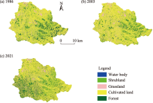
Fig. 1.
Land use/land cover (LULC) maps for the study area in 1986 (a), 2003 (b), and 2021 (c)."

Table 5
Total estimated ESV for each LULC type in 1986, 2003, and 2021."
| LULC type | 1986 | 2003 | 2021 | Percentage change in ESVs (%) | ||||
|---|---|---|---|---|---|---|---|---|
| ESVs (×107 USD) | Percentage of ESVs (%) | ESVs (×107 USD) | Percentage of ESVs (%) | ESVs (×107 USD) | Percentage of ESVs (%) | 1986-2003 | 2003-2021 | |
| Cultivated land | 2.36 | 31.80 | 2.63 | 40.90 | 2.25 | 29.00 | 2.75 | -3.81 |
| Forest | 1.52 | 20.50 | 0.93 | 14.40 | 2.38 | 30.60 | -5.92 | 14.50 |
| Shrubland | 3.02 | 40.70 | 2.49 | 38.60 | 2.79 | 36.00 | -5.33 | 3.06 |
| Grassland | 0.36 | 4.80 | 0.34 | 5.30 | 0.32 | 4.10 | -0.21 | -0.26 |
| Water body | 0.16 | 2.20 | 0.05 | 0.80 | 0.02 | 0.30 | -1.13 | -0.24 |
| Total | 7.42 | 100.00 | 6.44 | 100.00 | 7.76 | 100.00 | -9.84 | 13.24 |
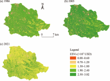
Fig. 2.
Spatial distribution of ecosystem service values (ESVs) in the upper Gilgel Abbay watershed in 1986 (a), 2003 (b), and 2021 (c)."

Table 6
Results of the estimated ecosystem service value function (ESVf)."
| ES | ES function | ESVf in 1986 (×106 USD) | ESVf in 2003 (×106 USD) | ESVf in 2021 (×106 USD) | Changes of ESVf between 1986 and 2003 (×106 USD) | Changes of ESVf between 2003 and 2021 (×106 USD) | |
|---|---|---|---|---|---|---|---|
| Provisioning service | Water supply | 0.79 | 0.40 | 0.48 | -0.39 | 0.08 | |
| Food production | 22.56 | 24.39 | 21.68 | 1.84 | -2.71 | ||
| Raw materials | 2.36 | 1.77 | 2.68 | -0.58 | 0.91 | ||
| Genetic resources | 1.89 | 1.42 | 2.15 | -0.47 | 0.73 | ||
| Total | 27.59 | 27.99 | 27.00 | 0.40 | -0.99 | ||
| Regulating service | Water regulation | 1.40 | 0.57 | 0.51 | -0.83 | -0.06 | |
| Climate regulation | 10.34 | 7.72 | 11.69 | -2.63 | 3.97 | ||
| Disturbance regulation | 0.23 | 0.17 | 0.26 | -0.06 | 0.09 | ||
| Gas regulation | 0.72 | 0.56 | 0.79 | -0.16 | 0.24 | ||
| Biological control | 2.80 | 3.07 | 2.65 | 0.28 | -0.43 | ||
| Erosion control | 11.63 | 8.82 | 13.15 | -2.81 | 4.33 | ||
| Waste treatment | 7.33 | 5.75 | 8.08 | -1.59 | 2.33 | ||
| Total | 34.45 | 26.65 | 37.13 | -7.80 | 10.47 | ||
| Supporting service | Nutrient cycling | 8.48 | 6.38 | 9.66 | -2.10 | 3.28 | |
| Pollination | 2.11 | 2.18 | 2.05 | 0.07 | -0.13 | ||
| Soil formation | 0.47 | 0.36 | 0.53 | -0.11 | 0.18 | ||
| Habitat/refuge | 0.80 | 0.60 | 0.91 | -0.20 | 0.31 | ||
| Total | 11.86 | 9.52 | 13.15 | -2.34 | 3.64 | ||
| Cultural service | Recreation | 0.24 | 0.18 | 0.26 | -0.06 | 0.08 | |
| Cultural heritage | 0.09 | 0.07 | 0.10 | -0.02 | 0.04 | ||
| Total | 0.34 | 0.25 | 0.37 | -0.09 | 0.12 | ||
| [1] | Abuhay W., Gashaw T., Tsegaye L., 2023. Assessing impacts of land use/land cover changes on the hydrology of Upper Gilgel Abbay watershed using the SWAT model. J. Agric. Food Res. 12, 100535, doi: 10.1016/j.jafr.2023.100535. |
| [2] | Afework A., Minale A.S., Teketay D., et al., 2023. Spatio-temporal dynamics of Acacia decurrens plantations in Awi Zone Highlands, Northwest Ethiopia. Papers in Applied Geography. 9(4), 442-463. |
| [3] | Alemu W.G., Melesse A.M., 2019. Impacts of long-term conservation measures on ecosystem services in Northwest Ethiopia. Int. Soil Water Conserv. Res. 8(1), 47-55. |
| [4] | Amare T., Amede T., Abewa A., et al., 2022. Remediation of acid soils and soil property amelioration via Acacia decurrens-based agroforestry system. Agrofor. Syst. 96(2), 329-342. |
| [5] | Anaya-Romero M., Muñoz-Rojas M., Ibáñez B., et al., 2016. Evaluation of forest ecosystem services in Mediterranean areas. A regional case study in South Spain. Ecosyst. Serv. 20, 82-90. |
| [6] | Anley M.A., Minale A.S., Haregeweyn N., et al., 2022. Assessing the impacts of land use/cover changes on ecosystem service values in Rib watershed, Upper Blue Nile Basin, Ethiopia. Trees For. People. 7, 100212, doi: 10.1016/j.tfp.2022.100212. |
| [7] | Arowolo A.O., Deng X.Z., Olatunji O.A., et al., 2018. Assessing changes in the value of ecosystem services in response to land-use/land-cover dynamics in Nigeria. Sci. Total Environ. 636, 597-609. |
| [8] | Belay T., Mengistu D.A., 2019. Land use and land cover dynamics and drivers in the Muga watershed, Upper Blue Nile basin, Ethiopia. Remote Sens. Appl.-Soc. Environ. 15, 100249, doi: 10.1016/j.rsase.2019.100249. |
| [9] | Berihun M.L., Tsunekawa A., Haregeweyn N., et al., 2021. Changes in ecosystem service values strongly influenced by human activities in contrasting agro-ecological environments. Ecol. Process. 10(1), 52, doi: 10.1186/s13717-021-00325-1. |
| [10] | Bogale T., Damene S., Seyoum A., et al., 2024. Land use land cover change intensity analysis for sustainable natural resources management: The case of northwestern highlands of Ethiopia. Remote Sens. Appl.-Soc. Environ. 34, 101170, doi: 10.1016/j.rsase.2024.101170. |
| [11] | Cademus R., Escobedo F.J., McLaughlin D., et al., 2014. Analyzing trade-offs, synergies, and drivers among timber production, carbon sequestration, and water yield in Pinus elliotii forests in southeastern USA. Forests. 5(6), 1409-1431. |
| [12] | Castro-Díez P., Alonso Á., Saldaña-López A., et al., 2021. Effects of widespread non-native trees on regulating ecosystem services. Sci. Total. Environ. 778, 146141, doi: 10.1016/j.scitotenv.2021.146141. |
| [13] | Congalton R.G., Green K., 2008. Assessing the Accuracy of Remotely Sensed Data (2nd ed.). Boca Raton: CRC Press. |
| [14] | Costanza R., De Groot R., Sutton P., et al., 2014. Changes in the global value of ecosystem services. Glob. Environ. Change-Human Policy Dimens. 26, 152-158. |
| [15] | D’Annunzio, R., Sandker, M., Finegold, Y., et al., 2015. Projecting global forest area towards 2030. For. Ecol. Manage. 352, 124-133. |
| [16] | De Groot R.S., Wilson M.A., Boumans R.M.J., 2002. A typology for the classification, description and valuation of ecosystem functions, goods and services. Ecol. Econ. 41(3), 393-408. |
| [17] | Debie E., Anteneh M., 2022. Changes in ecosystem service values in response to the planting of Eucalyptus and Acacia species in the Gilgel Abay Watershed, Northwest Ethiopia. Trop. Conserv. Sci. 15, doi: 10.1177/19400829221108928. |
| [18] | Deeksha N., Shukla A.K., 2022. Ecosystem services: A systematic literature review and future dimension in freshwater ecosystems. Appl. Sci.-Basel. 12(17), 8518, doi: 10.3390/app12178518. |
| [19] | Duguma L.A., Hager H., 2011. Farmers’ assessment of the social and ecological values of land uses in Central Highland Ethiopia. Environ. Manage. 47(5), 969-982. |
| [20] | Fagerholm N., Torralba M., Burgess P.J., et al., 2016. A systematic map of ecosystem services assessments around European agroforestry. Ecol. Indic. 62, 47-65. |
| [21] | Fu B.J., Zhang L.W., Xu Z.Z., et al., 2015. Ecosystem services in changing land use. J. Soils Sediments. 15(4), 833-843. |
| [22] | García-Llamas P., Geijzendorffer I.R., García-Nieto A.P., et al., 2019. Impact of land cover change on ecosystem service supply in mountain systems: A case study in the Cantabrian Mountains (NW of Spain). Reg. Envir. Chang. 19(2), 529-542. |
| [23] | Gashaw T., Tulu T., Argaw M., et al., 2018. Estimating the impacts of land use/land cover changes on ecosystem service values: The case of the Andassa watershed in the Upper Blue Nile basin of Ethiopia. Ecosyst. Serv. 31, 219-228. |
| [24] | Gashaw T., Worqlul A.W., Dile Y.T., et al., 2020. Evaluating potential impacts of land management practices on soil erosion in the Gilgel Abay watershed, upper Blue Nile basin. Heliyon. 6(8), e04777, doi: 10.1016/j.heliyon.2020.e04777. |
| [25] | Gu C.J., Zhang Y.L., Liu L.S., et al., 2021. Qualifying land use and land cover dynamics and their impacts on ecosystem service in Central Himalaya Transboundary landscape based on Google Earth Engine. Land. 10(5), 506, doi: 10.3390/land10020173. |
| [26] | Haile A.T., Rientjes T., 2015. Evaluation of regional climate model simulations of rainfall over the Upper Blue Nile basin. Atmos. Res. 161, 57-64. |
| [27] | Hundu W.T., Anule P.T., Kwanga G.M., et al., 2021. Assessment of land use and land cover change using GIS and remote sensing techniques in Katsina-Ala Local Government Area of Benue State, Nigeria. Journal of Research in Forestry, Wildlife and Environment. 13(4), 195-204. |
| [28] | Jiang W., Fu B.J., Lü Y.H., 2020. Assessing impacts of land use/land cover conversion on changes in ecosystem services value on the Loess Plateau, China. Sustainability. 12(17), 7128, doi: 10.3390/su12177128. |
| [29] | Ketema H., Wei W., Legesse A., et al., 2021. Ecosystem service variation and its importance to the wellbeing of smallholder farmers in contrasting agro-ecological zones of East African Rift. Food Energy Secur. 10(4), e310, doi: 10.1002/fes3.310. |
| [30] | Kindu M., Schneider T., Teketay D., et al., 2016. Changes of ecosystem service values in response to land use/land cover dynamics in Munessa-Shashemene landscape of the Ethiopian highlands. Sci. Total Environ. 547, 137-147. |
| [31] | Kusi K.K., Khattabi A., Mhammdi N., et al., 2020. Prospective evaluation of the impact of land use change on ecosystem services in the Ourika watershed, Morocco. Land Use Pol. 97, 104796, doi: 10.1016/j.landusepol.2020.104796. |
| [32] | Li S.C., Zhang H., Zhou X.W., et al., 2020. Enhancing protected areas for biodiversity and ecosystem services in the Qinghai-Tibet Plateau. Ecosyst. Serv. 43, 101090, doi: 10.1016/j.ecoser.2020.101090. |
| [33] | Markos M.G., Mihret D.U., Teklu E.J., et al., 2018. Influence of land use and land cover changes on ecosystem services in the Bilate Alaba Sub-watershed, Southern Ethiopia. Journal of Ecology and the Natural Environment. 10(9), 228-238. |
| [34] | Maxwell S., Fuller R.A., Brooks T.M., et al., 2016. Biodiversity: The ravages of guns, nets and bulldozers. Nature. 536(7615), 143-145. |
| [35] | MEA Millennium Ecosystem Assessment, 2005. Ecosystems and Human Well-Being:Synthesis. Washington D.C.: Island Press. |
| [36] | Mengist W., Soromessa T., Feyisa G.L., 2022. Estimating the total ecosystem services value of Eastern Afromontane Biodiversity Hotspots in response to landscape dynamics. Environ. Sustain. Indic. 14, 100178, doi: 10.1016/j.indic.2022.100178. |
| [37] |
Mhiret D.A., Dagnew D.C., Assefa T.T., et al., 2019. Erosion hotspot identification in the sub-humid Ethiopian highlands. Ecohydrol. Hydrobiol. 19(1), 146-154.
doi: 10.1016/j.ecohyd.2018.08.004 |
| [38] | Muleta T.T., Kidane M., Bezie A., 2020. The effect of land use/land cover change on ecosystem services values of Jibat forest landscape, Ethiopia. GeoJournal. 86(5), 2209-2225. |
| [39] | Nayak D., Shukla A.K., Devi N.R., 2024. Decadal changes in land use and land cover: impacts and their influence on urban ecosystem services. AQUA. 73(1), 57-72. |
| [40] | Nigussie Z., Tsunekawa A., Haregeweyn N., et al., 2020. The impacts of Acacia decurrens plantations on livelihoods in rural Ethiopia. Land Use Pol. 100, 104928, doi: 10.1016/j.landusepol.2020.104928. |
| [41] | NMSA (Ethiopia’s National Meteorological Services Agency), 2021. Climate Data Ethiopia’s National Meteorological Services Agency, Addis Ababa, Ethiopia. [2024-04-01]. https://www.ethiomet.gov.et. |
| [42] | Park S.J., Park S.Y., Park Y.B., 2018. An architecture framework for orchestrating context-aware IT ecosystems: A case study for quantitative evaluation. Sensors. 18(2), 562, doi: 10.3390/s18020562. |
| [43] | Randin C.F., Ashcroft M.B., Bolliger J., et al., 2020. Monitoring biodiversity in the Anthropocene using remote sensing in species distribution models. Remote Sens. Environ. 239, 111626, doi: 10.1016/j.rse.2019.111626. |
| [44] | Rientjes T.H.M., Haile A.T., Kebede E., et al., 2011. Changes in land cover, rainfall and stream flow in Upper Gilgel Abbay catchment, Blue Nile basin - Ethiopia. Hydrol. Earth Syst. Sci. 15(6), 1979-1989. |
| [45] | Rincón-Ruiz A., Arias-Arévalo P., Hernández J.M.N., et al., 2019. Applying integrated valuation of ecosystem services in Latin America: Insights from 21 case studies. Ecosyst. Serv. 36, 100901, doi: 10.1016/j.ecoser.2019.100901. |
| [46] | Rotich B., Kindu M., Kipkulei H., et al., 2022. Impact of land use/land cover changes on ecosystem service values in the Cherangany Hills Water Tower, Kenya. SSRN. Environmental Challenges. 8, 100576, doi: 10.2139/ssrn.4079129. |
| [47] | Sannigrahi S., Chakraborti S., Joshi P.K., et al., 2019. Ecosystem service value assessment of a natural reserve region for strengthening protection and conservation. J. Environ. Manage. 244, 208-227. |
| [48] | Sharma R., Rimal B., Baral H., et al., 2019. Impact of land cover change on ecosystem services in a tropical forested landscape. Resources-Basel. 8(1), 18, doi: 10.3390/resources8010018. |
| [49] | Shiferaw H., Alamirew T., Kassawmar T., et al., 2021. Evaluating ecosystems services values due to land use transformation in the Gojeb watershed, Southwest Ethiopia. Environmental Systems Research. 10(1), 22, doi: 10.1186/s40068-021-00227-3. |
| [50] | Styers D.M., Chappelka A.H., Marzen L.J., et al., 2010. Developing a land-cover classification to select indicators of forest ecosystem health in a rapidly urbanizing landscape. Landsc. Urban Plan. 94(3-4), 158-165. |
| [51] | Sutton P.C., Anderson S.J., Costanza R., et al., 2016. The ecological economics of land degradation: Impacts on ecosystem service values. Ecol. Econ. 129, 182-192. |
| [52] | Teixeira Z., Teixeira H., Marques J.C., 2014. Systematic processes of land use/land cover change to identify relevant driving forces: Implications on water quality. Sci. Total. Environ. 470, 1320-1335. |
| [53] | Tolessa T., Senbeta F., Abebe T., 2017. Land use/land cover analysis and ecosystem services valuation in the central highlands of Ethiopia. Forests Trees and Livelihoods. 26(2), 111-123. |
| [54] | Tolessa T., Gessese H., Tolera M., et al., 2018. Changes in ecosystem service values in response to changes in landscape composition in the central highlands of Ethiopia. Environ. Process. 5(3), 483-501. |
| [55] | Tolessa T., Kidane M., Bezie A., 2021. Assessment of the linkages between ecosystem service provision and land use/land cover change in Fincha watershed, North-Western Ethiopia. Heliyon. 7(7), e0767, doi: 10.1016/j.heliyon.2021.e07673. |
| [56] | Vo Q.T., Kuenzer C., Vo Q.M., et al., 2012. Review of valuation methods for mangrove ecosystem services. Ecol. Indic. 23, 431-446. |
| [57] | Wang Z.Y., Cao J.S., Zhu C.Y., et al., 2020. The impact of land use change on ecosystem service value in the upstream of Xiong’an New area. Sustainability. 12(14), 5707, doi: 10.3390/su12145707. |
| [58] | Wangai P.W., Burkhard B., Müller F., 2018. Quantifying and mapping land use changes and regulating ecosystem service potentials in a data-scarce peri-urban region in Kenya. Ecosyst. People. 15(1), 11-32. |
| [59] | Waters C.N., Zalasiewicz J., Summerhayes C., et al., 2016. The Anthropocene is functionally and stratigraphically distinct from the Holocene. Science. 351(6269), doi: 10.1126/science.aad2622. |
| [60] | Woldeyohannes A., Cotter M., Biru W.D., et al., 2020. Assessing changes in ecosystem service values over 1985-2050 in response to land use and land cover dynamics in Abaya-Chamo Basin, Southern Ethiopia. Land. 9(2), 37, doi: 10.3390/land9020037. |
| [61] | Zhang Y.S., Zhao L., Liu J.Y., et al., 2015. The impact of land cover change on ecosystem service values in urban agglomerations along the coast of the Bohai Rim, China. Sustainability. 7(8), 10365-10387. |
| [1] | Subrata HALDAR, Somnath MANDAL, Subhasis BHATTACHARYA, Suman PAUL. Dynamicity of Land Use/Land Cover (LULC): An analysis from peri-urban and rural neighbourhoods of Durgapur Municipal Corporation (DMC) in India [J]. Regional Sustainability, 2023, 4(2): 150-172. |
| Viewed | ||||||
|
Full text |
|
|||||
|
Abstract |
|
|||||
 REGSUS Wechat
 新公网安备 65010402001202号